
MyTopo
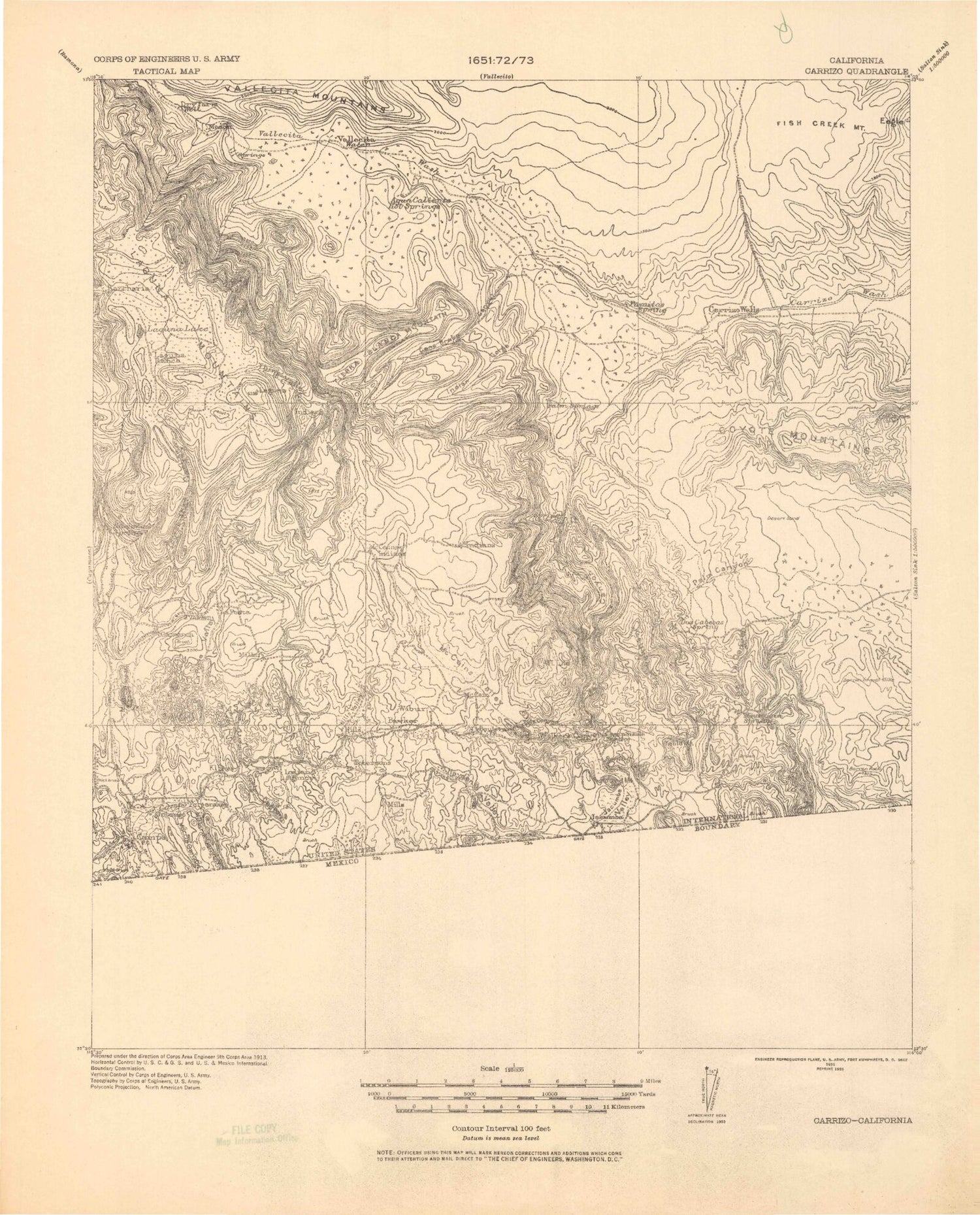
Historic 1931 Carrizo California 30'x30' Topo Map
Couldn't load pickup availability
Historical USGS topographic map of Carrizo in the state of California. Scale: 1:125000. Print size: 18" x 24"
This map was published in 1931 and is in the following counties: Imperial, San Diego.
The map contains contour lines, roads, rivers, towns, streams, and lakes. Printed on high-quality waterproof paper with UV fade-resistant inks.
Contains the following named places: Old Overland Stage Route, Agua Caliente County Park, Arroyo Hueso, Arroyo Seco Del Diablo, Arroyo Tapiado, Bankhead Springs, Barrett Canyon, Bisnaga Alta Wash, Boulder Creek, Boulder Park, Boulevard, Boundary Peak, Bow Willow Canyon, Bow Willow Creek, Bow Willow Palms, Bow Willow Ranger Station, Camels Head Wash, Campo Lake, Canebrake Canyon, Canebrake Wash, Carrizo Badlands, Carrizo Gorge, Carrizo Mountain, Carrizo Valley, Castle Rock Ranch, Coyote Mountains, Crawford Ranch, Ewiiaapaayp Reservation, Deguynos Canyon, Devils Canyon, Diabold Canyon, Dos Cabezas Mine, Easy Pickins Mine, Egg Mountain, Elliot Mine, Fossil Canyon, Gert Wash, Goat Canyon, Gray Mountain, Hill Valley, Imperial Highway Monument, In-Ko-Pah County Park, In-Ko-Pah Gorge, Indian Gorge, Indian Valley, Inner Pasture, Jacumba Hot Springs, Jacumba Mountains, Jacumba Peak, Jacumba Valley, Jewell Valley, June Wash, Lake Domingo, Lark Canyon, Lava Flow Wash, Little Devil Wash, Little Randsburg Mine, Little Valley, Loop Wash, Lost Valley, Lycium Wash, Manzanita, Manzanita Reservation, Marys Grove, McCain Ranch, McCain Valley, Mica Gem Mine, Mollusk Wash, Moonlight Canyon, Mortero Canyon, Mountain Palm Springs Area, Myer Creek, Myer Valley, North Fork Fish Creek Wash, North Fork Indian Valley, North Grove, North Wash, Old Carrizo Stage Station, Olla Wash, Oyster Shell Wash, Palm Bowl Grove, Pepperwood Trail, Piedras Grandes, Pygmy Grove, Red Rock Canyon, Red Top, Redondo Flat, Rockhouse Canyon, Round Mountain, Sandstone Canyon, Sawtooth Mountains, Smoke Tree Forest, Smuggler Canyon, Sombrero Peak, Sombrero Peak Palm Grove, South Fork Indian Valley, Southwest Grove, Squaw Canyon, Stage Station Historical Marker, Sugarloaf Mountain, Surprise Canyon Grove, Sweeney Pass, Table Mountain, Tecate Divide, Tierra Blanca Mountains, Torote Canyon, Tule Canyon, Tule Creek, Tule Lake, Mount Tule, Vallecito Stage Station County Park, View of Badland, Volcanic Hills, Walker Creek, Jojoba Wash, Dubber Spur, Blue Angels Peak, Canyon Nombre, Carrizo Canyon, Carrizo Creek, Carrizo Gorge, In-Ko-Pah Mountains, Mountain Spring, Tunnel Fifteen Spur, Vallecito Creek, La Posta Indian Reservation, Agua Dulce Creek, Al Bahr Shrine Camp, Ames Valley, Antone Canyon, Big Laguna Lake, Boiling Spring Ravine, Bonita Ravine, Burnt Rancheria Campground, Cameron Corners, Cameron Guard Station, Cameron Valley, Camp Ole Station, Campbell Grade, Campbell Ranch, Campo Forest Fire Station, Campo Indian Reservation, Campo Valley, Channing Meadow, Chico Ravine, Chula Vista Reservoir, Cibbets Flat, Clover Flat, Clover Flat Pit, Coogan Ranch, Cottonwood Canyon, Crouch Ranch, Crouch Valley, Cuyapaipe Reservoir, El Centro Ravine, El Prado Meadow, Escondido Ravine, Filaree Flat, Flathead Flats, Flinn Ranch, Fred Canyon, Garnet Mountain, Horse Canyon, Horse Heaven Group Camp, Horse Meadow, Indian Potrero, Joy Meadow, Kitchen Creek, Kitchen Valley, La Posta Creek, La Posta Indian Reservation, La Posta Ranch, La Posta Service, La Posta Valley, Laguna Campground, Laguna Meadow, Laguna Mountains, Laguna Ranch, Laguna Recreation Area, Little Laguna Lake, Long Canyon, Los Gatos Ravine, Los Huecos Reservoir, Los Rasalies Ravine, Lucas Creek, Madero Ravine, Mason Valley, Miller Creek, Miller Ranch, Miller Valley, Monument Peak, Morris Ranch, Noble Mine, Ole Reservoir, Paloma Ravine, Rodeo Grounds, Salt Creek, Sawtooth Range, Sheephead Mountain, Sierra Club Guymon Lodge, Simmons Canyon, Smith Canyon, Storm Canyon, Sundown Mine, Sweeney Canyon, The Narrows, The Potrero, Thing Ranch, Thing Valley, Thunder Valley, Troutman Mountain, Troy Canyon, Troy Flat, Un Gallo Flat, Vallecito Valley, Vallecito Wash, Verde Ravine, Wooded Hill, Desert View Interpretive Trail, Laguna Mountain Volunteer Association, Meadows Information Center, Indian Hill Nature Trail, Pioneer Mail, Garnet Information Center, Garnet Peak Trail, Witches Broom Trail, EL Prado Group Camp, Star Party Trail, Aqua Dulce, Boiling Spring Pump, Barrett, Boulder Oaks, Calexico Lodge, Campo, Clover Flat, Dos Cabezas


