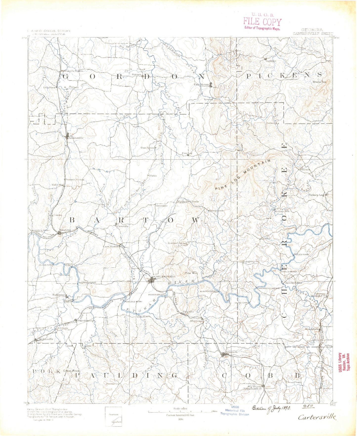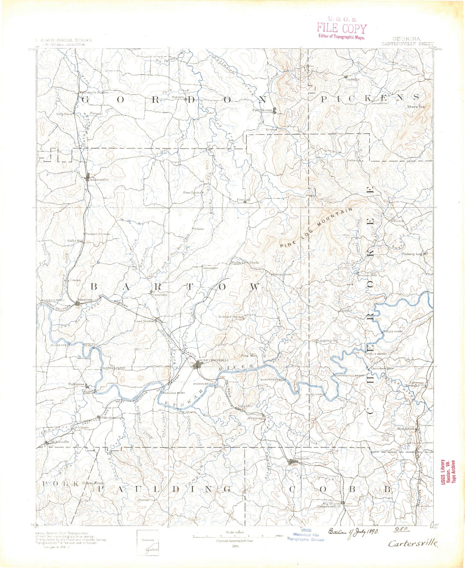
MyTopo
Historic 1890 Cartersville Georgia 30'x30' Topo Map
Couldn't load pickup availability
Historical USGS topographic map of Cartersville in the state of Georgia. Scale: 1:125000. Print size: 18" x 24"
This map was published in 1890 and is in the following counties: Bartow, Cherokee, Cobb, Gordon, Paulding, Pickens, Polk.
The map contains contour lines, roads, rivers, towns, streams, and lakes. Printed on high-quality waterproof paper with UV fade-resistant inks.
Contains the following named places: Abernethy Lake, Lake Acworth, Adairsville, Alexander Hollow, Allatoona Creek, Allatoona Lake, Lake Arrowhead, Ashpole Creek, Aubrey Lake, Ballard Creek, Barnsley Gardens, Beaman Branch, Bear Mountain, Big Branch, Big Branch, Blackwood Creek, Blankets Creek, Boston Creek, Bowen Branch, Bryant Creek, Burnt Hickory Ridge, Butler Creek, Byrd Creek, Cagle Mountain, Calico Valley, Campbell Hill, Carnes Lake, Carter Creek, Caseys Lakes, Cassville, Cedar Creek, Cement, Chastains Lakes, Clark Creek, Clear Creek, Clear Creek, Clear Lake, Connesena Creek, Cooper Branch, Corley Lake, Cross Trails, Davis Branch, Dews Lake, Downing Creek, Drum Creek, Drummond Swamp, Dry Branch, Floyd Creek, Dry Creek, Dunaway Branch, Ellison Lake, Euharlee, Euharlee Creek, Forked Branch, Fuller Branch, Gillespie Hollow, Goodwin Branch, Gorman Branch, Gourd Branch, Grassy Hollow, Green Pond, Hanging Mountain, Hawks Branch, Hodge Lake, Hodge Mountain, Holly Spring Branch, Holly Springs, Hurricane Hollow, Illinois Creek, Iron Hill Campground, Island Mill Bend, Jackson Branch, Jackson Creek, John Gunn Mountain, Jones Branch, Jug Creek, Kellogg Creek, Kennesaw, Kitchens Mountain, Knox Creek, Lake Myrtle, Laura Lake, Laurel Branch, Lebanon, Left Prong Pegamore Creek, Lick Creek, Limekiln Branch, Lipscomb Branch, Little Allatoona Creek, Little Creek, Little Creek, Little Log Creek, Little Noonday Creek, Little Pumpkinvine Creek, Little River, Little Shoal Creek, Lost Town Creek, Macedonia Slough, Mackey Branch, Manning Creek, Manning Lake, Marable Creek, Lake Margarete, Marlowe Branch, Maxwell Branch, McCanless Creek, McCory Creek, McEvers Branch, Middle Prong Pegamore Creek, Mill Creek, Mineral Spring Branch, Moore Branch, Moore Creek, Mud Creek, Murphy Bottom, Murry Creek, Nancy Creek, Noonday Creek, Oakey Mountain, Owl Creek, Peeples Valley, Pegamore Creek, Pegamore Lake, Penn Hollow, Picketts Mill Creek, Pine Mountain, Pinhook Creek, Pittman Lake, Pole Bridge Branch, Popham Branch, Posey Branch, Possum Creek, Proctor Creek, Puckett Creek, Pumpkinvine Creek, Raccoon Creek, Raper Creek, Red Mountain, Richland Creek, Right Prong Pegamore Creek, Rock House Creek, Rocky Bottom Branch, Rose Creek, Rowland Spring Creek, Rubes Creek, Ryle Creek, Salacoa Valley, Sardis Creek, Satterfield Branch, Schoolhouse Creek, Scott Branch, Scott Branch, Self Lake, Shanty Branch, Sharp Mountain, Shoal Creek, Shope Lake, Shut-in Creek, Signal Mountain, Sipsey Creek, Sonoraville, Spring Creek, Sproull Mountain, Stiles Creek, Sugar Hill Creek, Sugar Hill Pond, Sweetwater Creek, Tanyard Creek, Tate Creek, Taylors Lake, Taylors Swamp, Taylorsville, The Basin, Toonigh Creek, Univeter, Upper Aubrey Lake, Vineyard Mountain, Ward Creek, Webster Overlook, West Fork Pumpkinvine Creek, Westbrook Creek, Whispering Pines Camp, Wildcat Branch, Wildcat Ridge, Wildcat Ridge, Wiley Creek, Winkley Branch, Wolf Hollow, Wolfpen Branch, Wolfpen Gap, Wooten Lake, Halls, Bartow, Corbin, Five Forks, Five Forks, Jerusalem, Payne, Simpson Crossroads, Sutallee, Talmadge, Wolf Cave Mountain, Allatoona, Atco, Aubrey, Beasley Gap, Bee Mountain, Benson Lake, Bobo, Bolivar, Boyd Mountain, Bufford Mountain, Byrd Mountain, Carter Mountain, Cash, Cassville Mountain, Center, Cherokee, Collins Mountain, Colston Mountain, Connesena Mountain, Cooper Branch Landing, Cross Roads, Dobbins Mountain, Dry Pond Mountain, Emerson, Farmville, Fields Landing, Folsom, Fuller Mountain, Garland Mountain, Gee Mountain, Grassdale, Greely, Henderson Mountain, Henderson Mountain