MyTopo
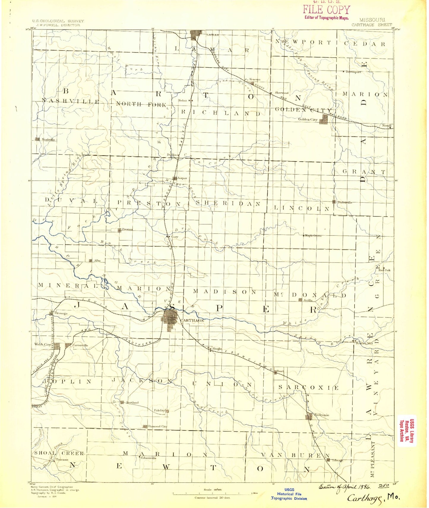
Historic 1886 Carthage Missouri 30'x30' Topo Map
Couldn't load pickup availability
Historical USGS topographic map of Carthage in the state of Missouri. Scale: 1:125000. Print size: 17" x 24"
This map was published in 1886 and is in the following counties: Barton, Dade, Jasper, Lawrence, Newton.
The map contains contour lines, roads, rivers, towns, streams, and lakes. Printed on high-quality waterproof paper with UV fade-resistant inks.
Contains the following named places: Alba, Atlas, Avilla, Blue Community Hall, Buck Branch, Camp Putnam, Carterville, Carthage, Cave Spring Branch, Coon Creek, Coon Creek, Cossville, Cripple Creek, Cyokamo Camp, Deer Creek, Dicks Fork, Dorris Creek, Dry Fork, Dry Valley Branch, Duenweg, Duquesne, Duval Creek, Fidelity Branch, Forest Mills, Fox Branch, Gateway Drive, Golden City, Grove Creek, Hatten Park, Jenkins Creek, Jones Creek, Kellogg Lake Park, Kendricktown, Kenoma, Kyle Creek, La Russell, Lakeside, Lamar, Lamar Heights, Lamar Lake, Leawood, Leonard Park, Little Coon Creek, Maple Grove, Maxville, Morgan Heights, Moss Springs Picnic Area, Motley Branch, Murphy Boulevard Park, Nashville, Oakland Park, Opossum Creek, Parshley, Pepsin, Pettis Creek, Pleasant Valley, Pleasant Valley, Preston, Prosperity, Purcell, Red Oak, Reeds, Rickman Creek, Royal Heights Park, Sagmount Bible Camp, Scotland, Silver Creek, Slater Branch, Stony Branch, Sunnyvale, Sunset Park, Thurman Creek, Tuckers Corner, Webb City, Webbs Lake, Boston, Brooklyn Heights, Dudenville, Fidelity, Freedom Community Center, Jasper, Liberty Community Hall, Neck City, Oakton, Oronogo, Pleasant View Community Center, Saginaw, Sarcoxie, Smith Community Center, Victory Community Center, West Fork River, White Oak Creek, Sams Branch, Bens Branch, East Joplin, Golden Grove, Clarkson, Rex City, Bushnell, Talmage City, Edwin, Knells Park, Browns, Esrom, Malty, Duval, Fair Banks, Mansur, Bowers Mill, Carytown, Dry Valley, Knights, Layneville, Motley, Plew, North Park Mall, Elms Shopping Center, East Gate Center, Bel-aire Shopping Center, Around Town Center, Melugin, Midway, Johnston, Joe Becker Memorial Stadium, Lamar Country Club, Davenport, Jasper County, Lamar Lake Dam, Lamar City Lake, Kellogg Lake Dam, Kellogg Lake, Shelton Lake Dam, Shelton Lake, Harlan Stump Dam, Scroggs Lake Dam, Scroggs Lake, Townley Lake Dam, Townley Lake, Schilling Lake Dam, Schilling Lake, Habeyle Dam, Habeyle Lake, Poirot Lake Dam Shallow Dam, Number 71 Lake, Bean Lake Dam, Beans Lake, Poirot Farms Incorporated Dam, Poirot Farms Lake, Sagehorn Lake Dam, Old Schreiner Lake, Marti Lake Dam, Marti Lake, Pepper Lake Dam, Bleuins Lake, Maple Lane Farms Lake Dam, Maple Lane Farms Lake, Pyle Lake Dam, Tidballs Dam, Tidballs Lake, Number 699 Dam, Lawless Lake, Number 700 Dam, Bentlages Lake, Berryhill Lake Dam, Number 703 Dam, Number 704 Dam, Diggs Lake Dam, Barker Lake Dam, Barker Lake, Garfield Lake Dam, Davis Lake Dam, Richards Lake Dam, Suiters Dam, Suiters Lake, Township of City, Township of Golden City, Township of Nashville, Township of Northfork, Township of Richland, Township of Grant, Township of Marion, Township of Duval, Township of Jackson, Township of Joplin, Township of Lincoln, Township of McDonald, Township of Madison, Township of Marion, Township of Mineral, Township of Preston, Township of Sarcoxie, Township of Sheridan, Township of Union, Township of Red Oak, Township of Marion, Shoal Creek Estates, City of Carterville, City of Carthage, City of Carytown, City of Alba, City of Duenweg, City of Golden City, City of Neck City, City of Jasper, City of La Russell, City of Lamar, City of Lamar Heights, City of Oronogo, City of Purcell, City of Sarcoxie, Town of Avilla, Town of Brooklyn Heights, Town of Reeds, Town of Fidelity, City of Webb City, Village of Shoal Creek Estates, Village of Duquesne, Village of Saginaw, Village of Silver Creek, Barco Drive-In, Powder Creek