MyTopo
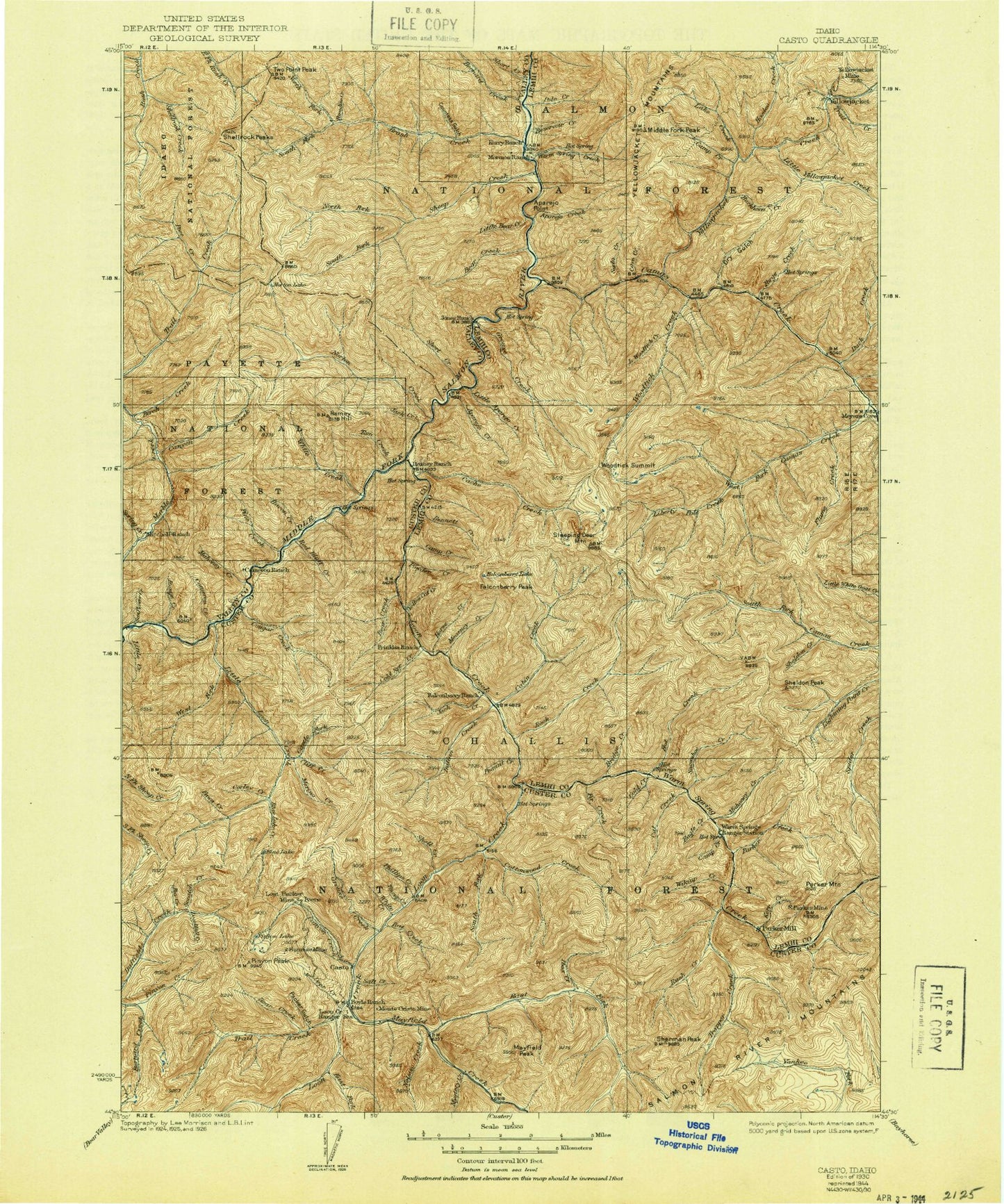
Historic 1930 Casto Idaho 30'x30' Topo Map
Couldn't load pickup availability
Historical USGS topographic map of Casto in the state of Idaho. Scale: 1:125000. Print size: 17" x 24"
This map was published in 1930 and is in the following counties: Custer, Lemhi, Valley.
The map contains contour lines, roads, rivers, towns, streams, and lakes. Printed on high-quality waterproof paper with UV fade-resistant inks.
Contains the following named places: Countess Gulch, Loon Creek Point, Pinyon Lake, Anvil Creek, Aparejo Creek, Aparejo Point, Bacon Creek, Bear Creek, Bear Creek Point, Bennett Creek, Bernard Creek, Bernard Creek Guard Station, Big Lead Mine, Birch Creek, Blue Lake, Blue Lake Creek, Boyle Ranch, Bridge Creek, Bridge Creek, Brush Creek, Brush Creek Summit, Buck Creek, Buckhorn Creek, Burn Creek, Burn Creek, Cabin Creek, Cache Creek, Cache Creek Cabin, Cache Creek Lakes, Camas Creek, Cameron Creek, Camp Creek, Camp Creek, Camp Creek, Canyon Creek, Canyon Creek, Castle Fork, Cat Creek, Cave Creek, China Creek, Cinch Creek, Cliff Creek, Cold Creek, Cold Spring Creek, Cold Spring Creek, Columbia Mine, Corduroy Creek, Corley Creek, Corner Creek, Cottonwood Creek, Cougar Creek, Cougar Creek Ranch, Cougar Lookout, Cove Creek, Cow Creek, Cub Creek, Culver Creek, Deadfall Creek, Deer Creek, Doe Creek, Doe Creek, Dry Gulch, Duck Creek, Eagle Creek, East Fork Mayfield Creek, Falconberry Guard Station, Falconberry Lake, Falconberry Peak, Falconberry Ranch, Fawn Creek, Feltham Creek Point, Fir Creek, Flume Creek, Fluorspar Gulch, Fly Creek Point, Ford Creek, Forge Creek, Foundation Creek, Fox Creek, Grouse Creek, Grouse Creek, Grouse Creek Peak, Grouse Lake, Hammer Creek, Heifer Creek, Hood Creek, Hoodoo Creek, Horn Creek, Horse Creek, Hospital Bar, Hospital Point, Hot Creek, Ibex Creek, Indian Creek, Indian Spring Guard Station, Jack Creek, Jack Creek, Jackass Creek, Jackass Flat, Jackass Gulch, Jenny Creek, Kelly Creek, Kerr Creek, Kidney Lake, Lake Creek, Liberty Creek, Liberty Lakes, Little Aparejo Creek, Little Bear Creek, Little Creek, Little Creek Guard Station, Little Dry Gulch, Little Loon Creek, Little Woodtick Creek, Loon Creek Guard Station, Loon Creek Lookout, Lost Packer Mine, Macarte Creek, Mahoney Creek, Mahoney Creek, Martindale Creek, Mayfield Creek, Mayfield Peak, McKee Creek, Mearney Creek, Melville Creek, Merino Creek, Meyers Cove, Mid Cottonwood Point, Middle Fork Peak, Middle Fork Peak Campground, Middle Fork Salmon Wild and Scenic River, Mormon Ranch, Mystery Creek, Ned Creek, Nelson Creek, No Name Creek, North Fork Brush Creek, Norton Creek, Norton Lake, Norton Ridge, Norton Ridge Lookout, Owen Cabin, Packer Gulch, Paradise Creek, Parker Creek, Parker Mill, Parker Mine, Parker Mountain, Peanut Creek, Phillips Creek, Pierson Creek, Pine Creek, Pinyon Creek, Pinyon Peak, Placer Creek, Poee Creek, Pole Creek, Pole Lake, Powder Creek, Prospect Creek, Rat Creek, Red Bluff Creek, Red Jacket Mine, Red Spar Mine, Reservoir Creek, Rock Creek, Rock Creek Campground, Rock Lakes, Salt Creek, Scratch Creek, Sheep Creek, Sheldon Creek, Sheldon Peak, Shell Creek, Shellrock Creek, Shellrock Peak, Shellrock Ridge Trail, Shep Creek, Sherman Peak, Short Creek, Silver Creek, Simplot Campground, Slaughterhouse Gulch, Sleeping Deer Mountain, Slide Creek, Sliderock Ridge, Snowshoe Creek, South Fork Brush Creek, South Fork Campground, South Fork Cottonwood Creek, South Fork Norton Creek, South Fork Sheep Creek, Spring Creek, Sunflower Creek, Tappan Gulch, Tappan Ranch, Telephone Creek, Tin Cup Mine, Tincup Campground, Tincup Creek, Tom Creek, Trail Creek, Trail Creek, Transfer Campground, Trapper Creek, Warm Spring Ranger Cabin, West Fork Camas Creek, West Fork Lakes, West Fork Little Loon Creek, West Fork Mayfield Creek, White Creek, White Creek, Wickiup Creek, Woodtick Creek, Woodtick Lake, Woodtick Summit, Yellow Cat Creek, Yellowjacket Creek, Yellowjacket Mine, Yellowjacket Ranch, Horse Heaven Meadows, Haystack Rapids, South Fork Warm Spring Creek, Phillips Creek Transfer Campground, Mayfield Creek Recreation Site, Mystery Creek Recreation Site, Rat Creek Recreation Site, Monte Cristo Recreation Site, China Creek Recreation Site, Cow Basin, Pine Creek Flat Campsite, Mahoney Campsite, Cameron Campsite, Little Creek Campsite, Upper Jackass Flat Campground