
MyTopo
Historic 1900 Chappell Nebraska 30'x30' Topo Map
Couldn't load pickup availability
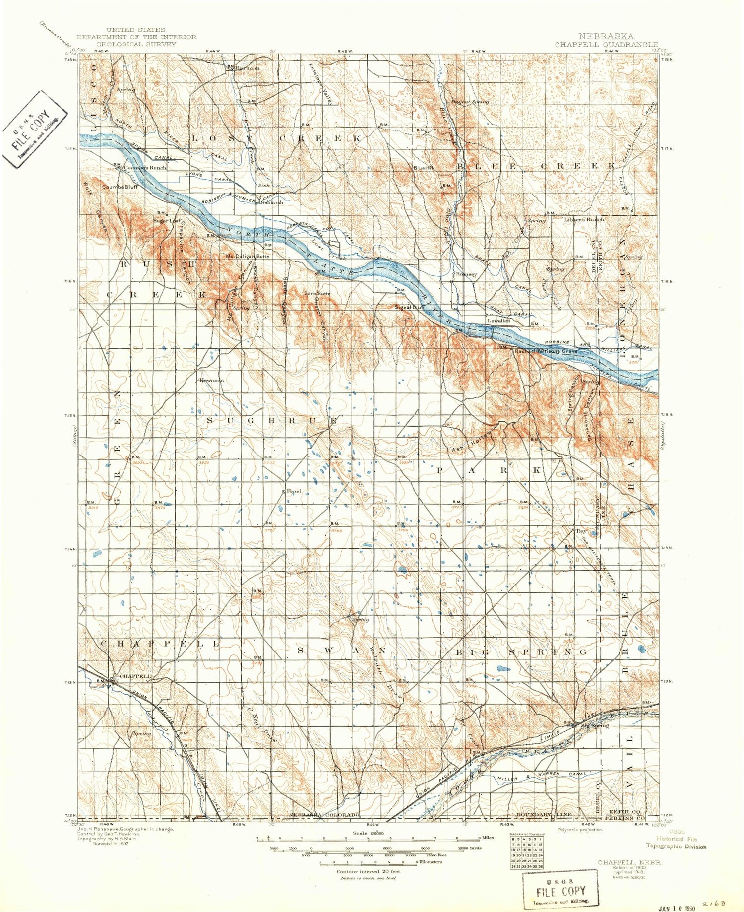
Historical USGS topographic map of Chappellin the states of Nebraska, Colorado, Wyoming. Scale: 1:125000. Print size: 17" x 24"
This map was published in 1900 and is in the following counties: Deuel, Garden, Keith, Perkins, Sedgwick.
The map contains contour lines, roads, rivers, towns, streams, and lakes. Printed on high-quality waterproof paper with UV fade-resistant inks.
Contains the following named places: State Line Ditch, Antelope Valley, Ash Creek, Ash Hollow, Ash Hollow State Historical Park, Barn Butte, Big Springs, Blue Creek, Blue Creek Canal, Bluewater Battlefield Overlook Site, Brush Canyon, Chappell, Clay Peak, Clear Creek, Clear Creek State Waterfowl Management Area, Coumbe Bluff, Dankworth Canyon, Delatour Ranch, Devils Washbasin, Dry Creek, Eagles Cliff, Emigrant Trail, Graf Canal, Grapevine Canyon, Hartley Draw, Hooper Canal, Lewellen, Lost Creek, Lyons Canal, McCuligan Butte, McCuligan Canyon, Midland Overland Canal, Midland Overland Canal, Mutton Creek, North River Canal, O Neil Draw, Old Baldy, Olson Ranch, Onstot Canyon, Oregon Trail, Oshkosh, Oshkosh Canal, Oshkosh Canal, Paisley Canal, Peterson Ditch, Plum Creek, Signal Bluff, Spohn Canal, Spring Canyon, State Line Ditch, Sugar Loaf, Swede Canyon, Trailer House Gulch, Twin Buttes, Union Canal, Walrath Draw, Walrath Draw, Western Canal, Wild Horse Canyon, Windlass Hill, Wolf Canyon, Barton, Ruthton, Deuel County, Oshkosh Country Club, Lobner Group Dam, Lobner Group Reservoir, Beasley Dam 25-01, Beasley Reservoir, Lobner Dam, Lobner Reservoir, Jackson-Paisley-Robinson Dam, Jackson-Paisley-Robinson Reservoir, Dorman Dam, Dorman Reservoir, Oshkosh Grain Incorporated Elevator, Oshkosh, Battle of Blue Water Historical Marker, Penn, New Oshkosh, Farmers Elevator, Garden County Fairgrounds, Retes Camper Park, Dougs Texaco Campground, John Hollman Grave Historical Marker, Js Otter Creek Resort, Wallesen Grain Company Incorporated Elevator, Ash Hollow Historical Marker, Ash Hollow Geology Historical Marker, Windlass Hill Pioneer Homestead Historical Marker, Ash Hollow Trail, Lewellen, Stahr Trailer Court, Mobile Manor Trailer Park, Farmers Elevator Company Elevator, Chappell, Big Springs, El Rancho Campground, Deuel County Fairground, Farmers Cooperative Elevator Association Elevator, Bittersweet State Wildlife Management Area, Goldeneye State Wildlife Management Area, Goldeneye Lake, McGreer Camper Park, Chappell Golf Course, Creekside RV Park and Campground, Chappell Lake, Phelps Hotel Historical Marker, Sam Bass and the Big Springs Robbery Historical Marker, Pony Express Nine Mile Station Marker, B-24J Bomber Crash Historical Marker, Pony Express Park, Eiker Park, Waterman Sod House Historical Marker, Big Springs Junction, Great Platte River Road Historical Marker, Julesburg and Fort Sedgwick Historical Marker, Big Springs Historical Marker, Big Springs Rest Area, Chappell Rest Area - Westbound, Big Springs Election Precinct, Oshkosh Number 1 Election Precinct, Swan Election Precinct, City of Chappell, City of Oshkosh, Village of Big Springs, Village of Lewellen, State Line Ditch, State Line Ditch, Emigrant Trail


