MyTopo
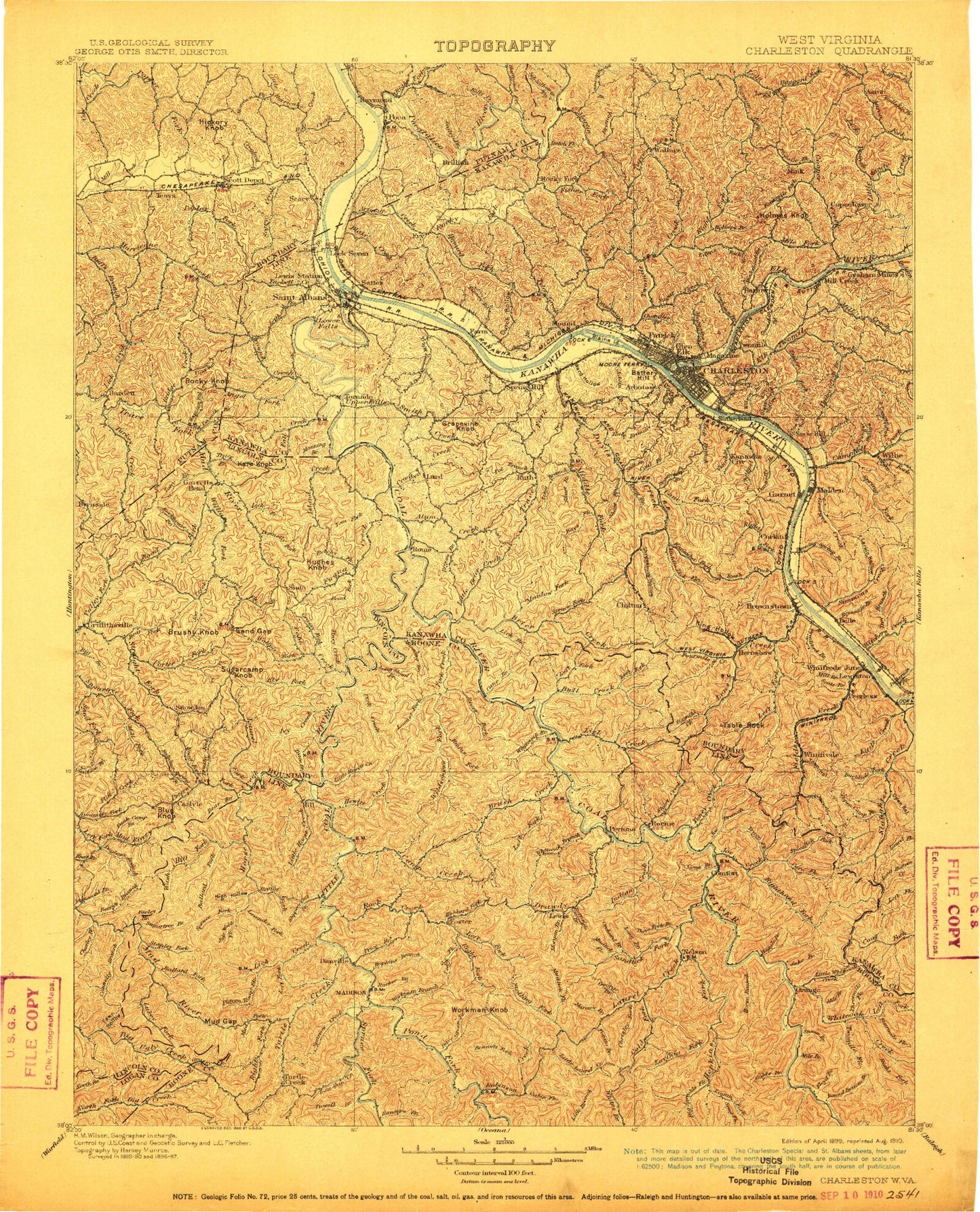
Historic 1899 Charleston West Virginia 30'x30' Topo Map
Couldn't load pickup availability
Historical USGS topographic map of Charleston in the state of West Virginia. Scale: 1:125000. Print size: 17" x 24"
This map was published in 1899 and is in the following counties: Boone, Kanawha, Lincoln, Logan, Putnam.
The map contains contour lines, roads, rivers, towns, streams, and lakes. Printed on high-quality waterproof paper with UV fade-resistant inks.
Contains the following named places: Aarons Creek, Adkins Fork, Adkins Fork, Airport Village, Alex Fork, Alkol, Alum Creek, Amandaville, Andrew, Angel Branch, Angel Fork, Armour Creek, Bailey Branch, Baisden Fork, Baker Fork, Ball Fork, Ballard Branch, Ballard Fork, Barkcamp Branch, Barn Hollow, Bat Branch, Bays Fork, Bear Branch, Bear Fork, Bearcamp Branch, Bee Mountain, Beech Branch, Bennett Fork, Bens Fork, Berry Branch, Big Branch, Big Branch, Big Coal River, Big Deadening Creek, Big Hollow, Big Horse Creek, Big Jarrells Creek, Big Pinnacle Branch, Big Spring Fork, Bills Creek, Black Betsey, Black Hog Hollow, Blackhawk Hollow, Blacksnake Hollow, Blaine Island, Blakes Creek, Bloomingrose, Blue Knob, Blue Tom Tunnel, Boardtree Hollow, Boardtree Run, Bonham Branch, Boone Block Hollow, Bowman Fork, Bradford Hollow, Bradley Fork, Bragg Fork, Brawleys Hollow, Bridge Creek, Brier Branch, Brier Creek, Brooks Hollow, Brown Branch, Browns Branch, Browns Creek, Brush Creek, Brushy Branch, Brushy Fork, Bryan Branch, Buck Branch, Buck Fork, Buckeye Fork, Buffs Branch, Bull Creek, Bullskin Branch, Burgess Hollow, Burning Spring Branch, Burnside Branch, Cabin Fork, Cain Branch, Cameo, Camp Creek, Camp Virgil Tate, Campbells Branch, Campbells Creek, Campbells Hollow, Cane Branch, Cane Fork, Cantley Branch, Carroll Branch, Carrow Fork, Cat Gut Hollow, Chapman Branch, Chappell Hollow, Chapps Branch, Charley Hollow, Lake Chaweva, Cherry Tree Hollow, Cherry Tree Hollow, Chrisley Fork, Clay Bank Branch, Claylick Branch, Clover Hollow, Coal Fork, Coal Fork, Coal Hollow, Coal Hollow, Coal Mountain, Coal River, Cobb Creek, Cold Fork, Comfort, Connelly Branch, Cooks Hollow, Cool Lake, Coolspring Branch, Coon Branch, Coon Fork, Coon Hollow, Coonskin Branch, Coonskin Park, Coopers Creek, Coopers Hollow, Copen Branch, Cow Creek, Cox Fork, Craig Branch, Creed, Crooked Creek, Crooked Creek, Crouch Hollow, Curtis Branch, Danville, Dave Fork, Davis Creek, Davis Creek Camping Area, Davis Creek Picnic Area, Diamond, Dickinson Lake, Dicks Creek, Dodson Fork, Dodson Junction, Dogbone Branch, Dolans Fork, Donley Fork, Dotson Fork, Drawdy Creek, Drawdy Falls Roadside Park, Dry Branch, Dry Branch, Dry Branch, Dry Branch, Dry Branch, Dry Branch, Dry Branch, Dry Branch, Dry Ridge, Dryden Hollow, Dunbar, Dunlop Hollow, Dupont City, Dutch Fork, Dutch Hollow, Easly, Easter Fork, Edens Fork, Elk Forest, Elk Hills, Elk Lick, Elk Twomile Creek, Ellis Fork, Ely Fork, Emmons, Ezekiel Branch, Falling Rock Fork, Falls Branch, Falls Creek, Farley Creek, Fawn Hollow, Ferneys Branch, Ferry Branch, Fields Brook, Fields Creek, Finney Branch, Fisher Branch, Fivemile Fork, Flat Creek, Flat Hollow, Flint Hollow, Flood Hollow, Fork Creek, Foster Hollow, Fosterville, Fourmile Branch, Fourmile Fork, Fourmile Fork, Fowler Fork, Frey Hollow, Frozen Hollow, Fudge Branch, Fuquay Creek, Gallatin Branch, Garretts Bend, George Branch, Georges Creek, Gidd Branch, Gill Hollow, Glovers Pond, Grassy Fork, Grassy Fork, Green Bottom, Grider Fork, Griffith Branch, Griffithsville, Grindstone Hollow, Gritter Hollow, Grobes Branch, Gum Hollow, Guthrie, Hager Hollow, Haggle Branch, Halls Fork, Hammack Hollow, Hanson Branch, Harmon Branch, Harmond Creek, Harris Hollow, Hawes Hollow, Hayzlett Fork, Heizer Creek, Hernshaw, Hewitt Creek, High Hollow, Hill Branch, Hill Fork, Hill Fork