MyTopo
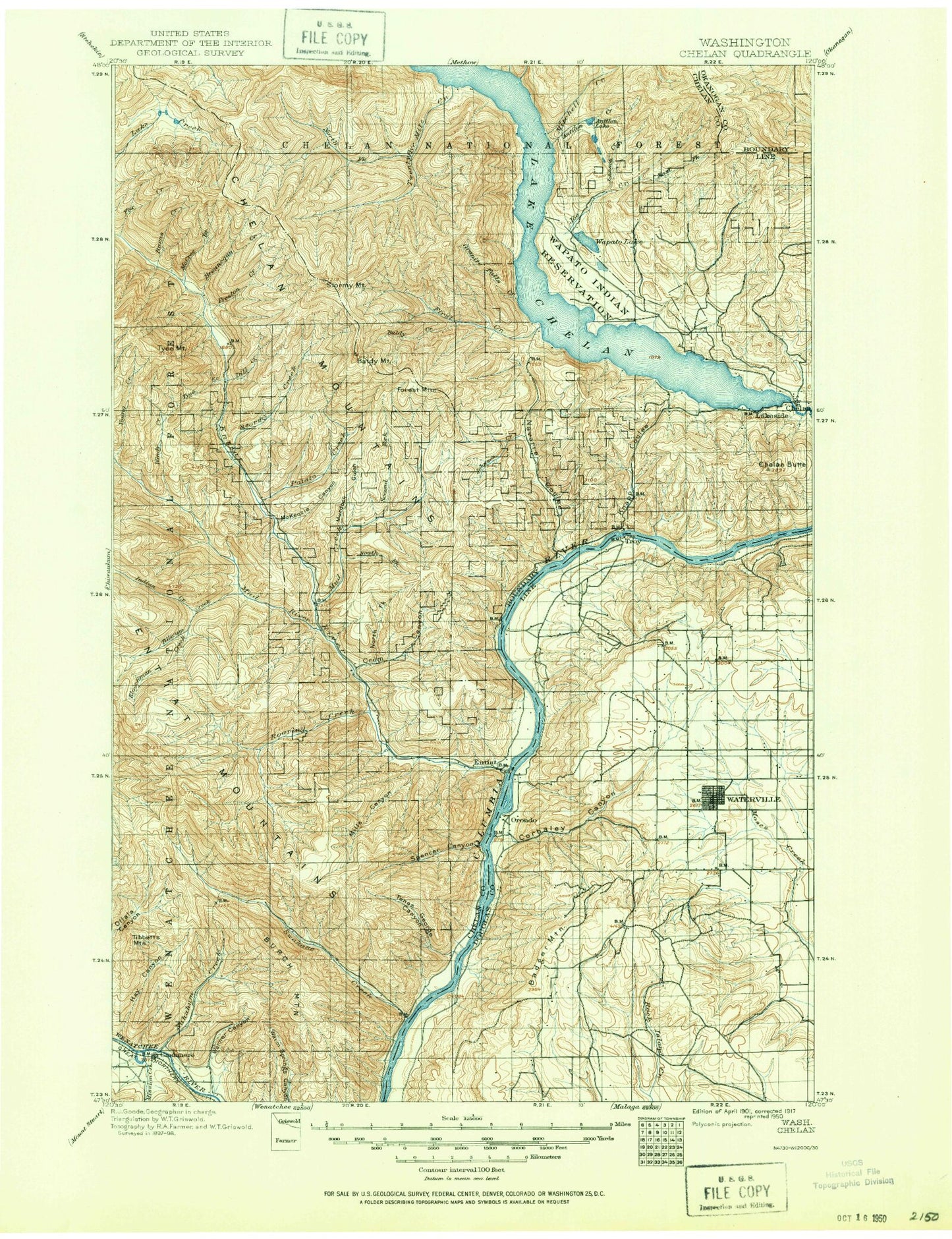
Historic 1901 Chelan Washington 30'x30' Topo Map
Couldn't load pickup availability
Historical USGS topographic map of Chelan in the state of Washington. Scale: 1:125000. Print size: 17" x 24"
This map was published in 1901 and is in the following counties: Chelan, Douglas, Okanogan.
The map contains contour lines, roads, rivers, towns, streams, and lakes. Printed on high-quality waterproof paper with UV fade-resistant inks.
Contains the following named places: Dinkelman Ridge, Angle Peak, Antilon Creek, Antilon Lake, Ardenvoir, Asher Canyon, Baldy Creek, Baldy Mountain, Barrett Creek, Bear Creek, Bear Gulch, Bear Lake, Bear Mountain, Bergman Gulch, Billy Ridge, Bisping Canyon, Brender Creek, Brennegan Creek, Brief, Browns Canyon, Buck Ridge, Burch Mountain, Burns Creek, Byers Canyon, Byrd Canyon, Cagle Gulch, Camp Nine, Canyon Ranch, Cashmere, Chelan Butte, Chelan Mountains, Chesapeake Saddle, Chumstick Mountain, Cooper Gulch, Corbaley Canyon, Corral Canyon, Crescent Hill, Crum Canyon, Darby Draw, Davis Canyon, Decker Canyon, Devils Backbone, Dick Mesa, Dill Creek, Dinkelman Canyon, Dissmore Canyon, Douglas, Douglas Draw, Dover Flat, Dry Lake, Eagle Rock, Earthquake Point, East Fork Joe Creek, East Point, Entiat, Entiat Ditch, Entiat River, Entiat Valley, Entiat Valley Ski Area, Lake Entiat, First Creek, Forest Mountain, Fourmile Ridge, Fourth of July Mountain, Gene Creek, Goff Peak, Gold Creek, Goman Peak, Goosetail Rock, Grandma Creek, Granite Falls Creek, Granite Slide, Gray Canyon, Greens Canyon, Greens Landing, Grouse Mountain, Grouse Mountain Campground, Hanan Canyon, Harris Creek, Hay Canyon, Hazel Camp, Hollywood Beach, Homestead Canyon, Hornet Creek, Icicle Canal, Indian Creek, Joe Creek, Johnson Creek, Johnson Creek, Junior Point, Keystone Canyon, Keystone Point, Kloochman Creek, Knapp Coulee, Kummer Draw, Lake Chelan State Park, Lake Creek Basin, Lakeshore Park, Lakeside, Lincoln Rock, Lone Peak, Lower Pawn Lake, Mad River, Manson, Maple Canyon, Maple Creek, McArthur Canyon, McCrea Creek, McGinnis Canyon, McKenzie Canyon, McKenzie Ridge, McKenzie Saddle, McKinstry Canyon, McLeish Canyon, Medicine Creek, Medsker Canyon, Mills Canyon, Minneapolis Beach, Mission Creek, Missouri Harbor, Mitchell Creek, Moe Canyon, Moe Ridge, Moody Canyon, Morical Canyon, Mosquito Ridge, Mott Creek, Mud Creek, Murdock Gulch, Nahahum Canyon, Navarre Coulee, North Fork Crum Canyon, North Fork Gray Canyon, North Fork Mud Creek, North Fork Paine Creek, North Fork Potato Creek, North Fork Thirtyfive Mile Creek, Oklahoma Gulch, Orondo, Osburn Canyon, Paine Creek, Palmich Canyon, Pine Canyon, Pine Flat Campground, Pot Peak, Potato Creek, Prairie Spring Campground, Preston Creek, Preston Falls, Purtteman Gulch, Ramona Park Campground, Ribbon Cliff, Ribbon Mesa, Ringstead Canyon, Roaring Creek, Roaring Ridge, Rocky Reach Dam, Roses Lake, Rothrock Ridge, Roundy Creek, Ruud Canyon, Saunders Canyon, Shady Pass, Shamel Creek, Shrine Beach, Silicosaska Park, Slide Peak, Slide Ridge, Sourdough Creek, South Fork Mud Creek, South Fork Grays Canyon, South Fork Paine Creek, South Fork Preston Creek, Spaders Bay, Spencer Canyon, Spencer Lake, Spring Canyon, Standpipe Hill, Stanley Canyon, Stayman, Steliko Canyon, Stink Creek, Stormy Creek, Stormy Mountain, Sunnybank, Sunshine Canyon, Swakane Creek, Swanson Gulch, Switchback Canyon, Tamarack Creek, Tenas George Canyon, Tibbetts Mountain, Tillicum Creek, Tiny Canyon, Turtle Rock, Twentyfive Mile Creek Guard Station, Twentyfive Mile Creek, Tyee Creek, Tyee Mountain, Upper Pawn Lake, Wagnersburg, Wapato Lake, Wapato Point, Warner Canyon, Washington Butte, Waterville, Waterville Plateau, Wilkinson Canyon, Will Risk Memorial Park, Willow Point, Windy Creek, Winesap, Young Creek, Young Creek Shelter, Entiat State Wildlife Area, Twenty-Five Mile Creek State Park, Ficher Canyon, Peters Point, Lake Chelan Dam, Entiat National Fish Hatchery, Steliko, Entiat Ranger Station, Chelan Ranger Station, Devils Backbone Trailbike Loop Trail, Old Mill Park, Lakeside City Park, Lady of the Lake Commercial Dock, Chelan River Boat Launch, Chelan Riverwalk Park, Darnells, Chelan County Park, South Shore, Echo Valley Ski Area, Fields Point, Wenatchee Boat Club, Watsons Harverene