
MyTopo
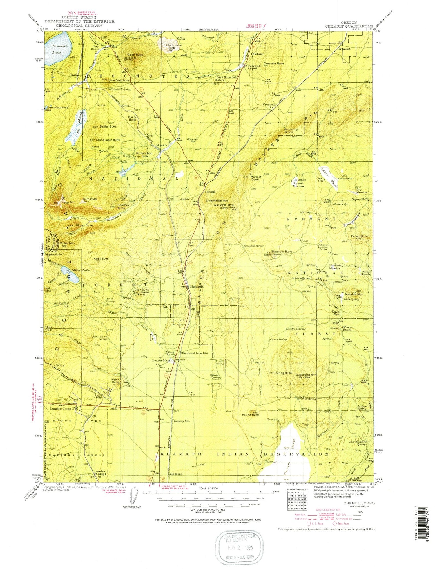
Historic 1935 Chemult Oregon 30'x30' Topo Map
Couldn't load pickup availability
Historical USGS topographic map of Chemult in the state of Oregon. Scale: 1:125000. Print size: 17" x 24"
This map was published in 1935 and is in the following counties: Douglas, Klamath.
The map contains contour lines, roads, rivers, towns, streams, and lakes. Printed on high-quality waterproof paper with UV fade-resistant inks.
Contains the following named places: Adell Butte, Basin Creek, Beales Butte, Bear Creek, Beaver Marsh, Bedpan Burn, Big Marsh, Big Marsh Creek, Black Rock Butte, Buckeye Butte, Bunny Butte, Burn Butte, Burn Creek, Camp Makualla, Cappy Mountain, Chinquapin Butte, Clover Butte, Clover Creek, Cole Creek, Cottonwood Creek, Cow Camp, Crescent, Crescent Siding, Crescent Butte, Crescent Creek Recreation Site, Crescent Reservoir, Crooked Meadow, Davis Flat, Deer Butte, Deer Creek, Desert Creek, Diamond Lake Junction, Digit Point Recreation Site, Dry Meadow, Dublin Creek, Evening Creek, Fly Creek, Gideon Creek, Gilchrist, Gilchrist Junction, Gilchrist Reservoir, God Butte, God Creek, Halfway House, Hemlock Butte, Hemlock Creek, Hidden Meadow, Howlock Creek, Jack Creek Corral, Jackies Thicket, Jamison Meadow, Jamison Ranch, Johnson Meadow, Johnson Meadow Guard Station, Junction Burn, Lane Creek, Lane Ranch, Lily Camp, Little Odell Butte, Little Odell Creek, Little Round Meadow, Little Walker Mountain, Lost Creek, Lower Davis Flat, Marmot Butte, Marmot Pass, McCarty Meadow, Miller Creek, Miller Lake, Miller Mountain, Mosquito Creek, Mosquito Flat, Mowich, Muttonchop Butte, O'Conner Meadow, Odell Butte, Odell Pasture, Oldenburg Lake, Otter Creek, Paddys Meadow, Parker Butte, Pumice Flat, Rabbit Creek, Rainbow Creek, Rainbow Point, Rakes Meadow, Red Cone, Refrigerator Creek, Riders Camp, Round Butte, Round Meadow, Sellers Creek, Sellers Marsh, Shoestring Creek, Silent Creek, Simax Bay, Sink Creek, Skookum Butte, Sproats Meadow, Spruce Creek, Stimson Meadow, String Butte, Sugarpine Burn, Sugarpine Mountain, Swamp Creek, Tea Table Mountain, The Rhubarb Patch, Three Creek, Three Creek Guard Station, Three Creek Ridge, Tiny Creek, Tipsoo Creek, Umli, Walker Mountain, Walker Rim, Welch Butte, Willow Campground, Zims Point, Basin Cove, Hoey Point, Rock Point, Beaver Marsh Guard Station, Mazama Junction, Beaver Marsh, JC Collins Ranch, Pacific Telephone and Telegraph Substation, Boundary Springs Recreation Site, Diamond Crater, Digit Point Trailhead, Sugarpine Mountain Lookout, Mazama Sheep Corral, Lower Walker Quarry, Crescent Lake, Sagebrush Point, Simax Group Campground, Maidu Lake Recreation Site, Gilchrist Log Pond, Squirrel Camp, Beaver Marsh Safety Rest Area, Bingham Park, Rainbow Cove, Chemult, Diamond Lake, Mazama, Yamsay, Walker Mountain Lookout station, Simax Beach Recreation Site, Corral Springs Recreation Site, Walt Haring Sno-Park, Crescent Lake Division, Gilchrist Sewer Company, Interfor Pacific Gilchrist Biomass Facility, Digit Point Campground Boat Ramp, Crescent Creek Wild and Scenic River, Big Marsh Creek Wild and Scenic River, Little Deschutes Wild and Scenic River


