MyTopo
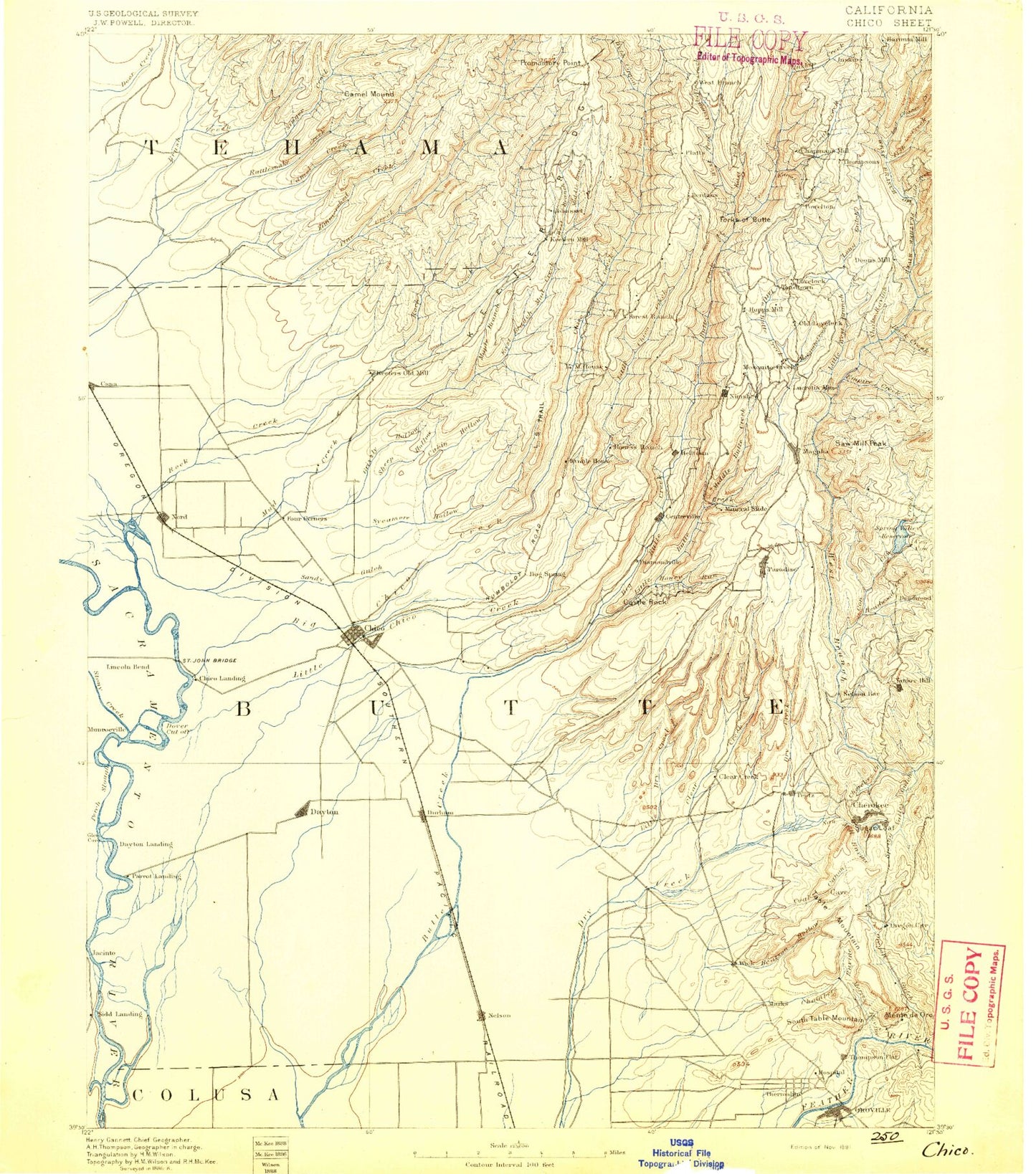
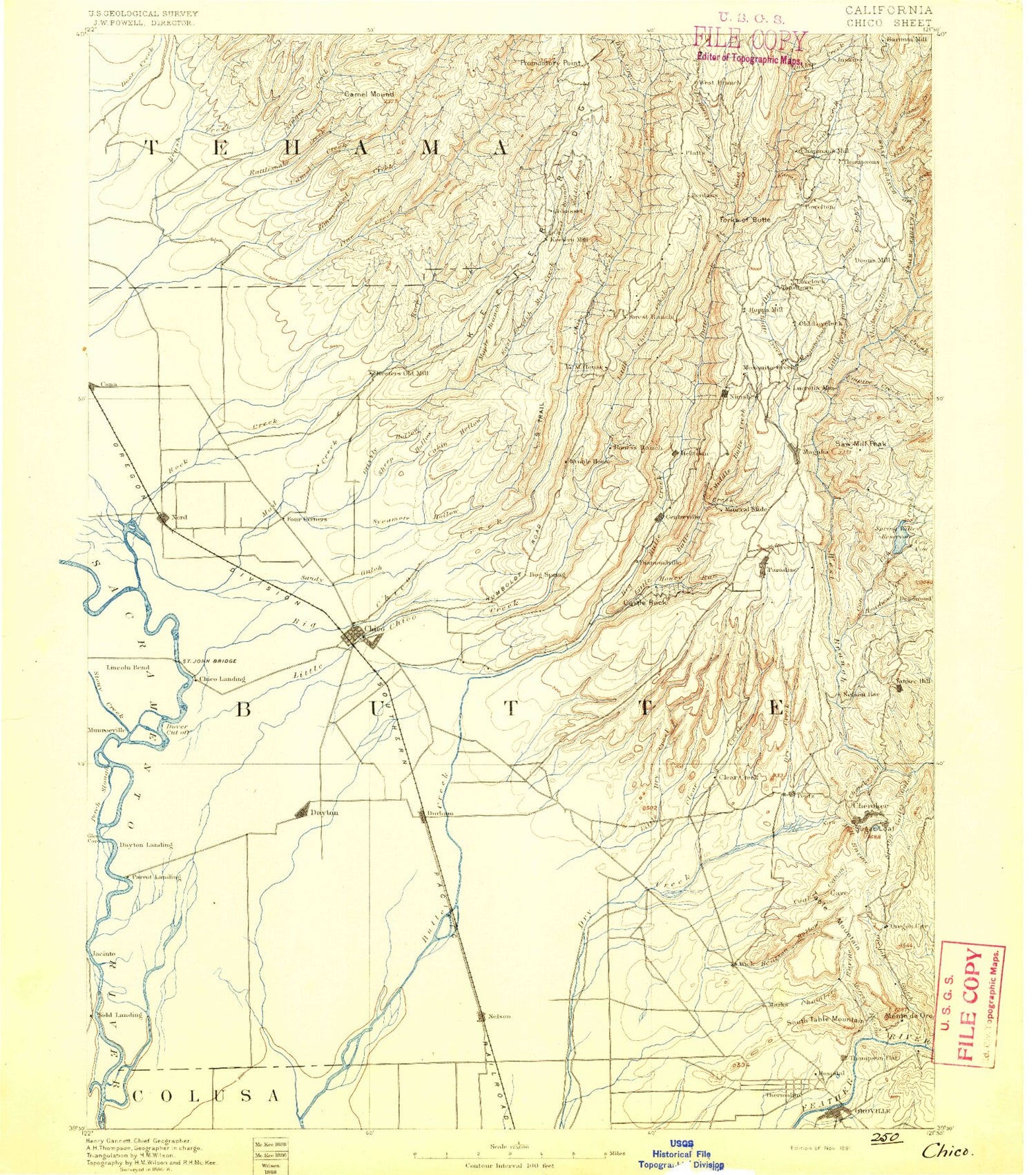
Historic 1891 Chico California 30'x30' Topo Map
Couldn't load pickup availability
Historical USGS topographic map of Chico in the state of California. Scale: 1:125000. Print size: 17" x 24"
This map was published in 1891 and is in the following counties: Butte, Glenn, Tehama.
The map contains contour lines, roads, rivers, towns, streams, and lakes. Printed on high-quality waterproof paper with UV fade-resistant inks.
Contains the following named places: Banner Mine, Beatson Hollow, Beauty Peak, Bedrock Park, Bell Ranch, Bidwell Mansion State Historic Park, Bidwell Park, Bidwell Park, Bidwell River Park, Black Diamond Mine, Bloomingdale Mine, Brush Creek, Buffalo Mine, Bumblebee Mine, Butte County Center, Butte Creek Diversion Channel, Cabin Hollow, Campbell Creek, Campbell Creek, Campbell Flat, Campbell Hills, Cannon Reservoir, Channel Slough, Clarenback Point, Clear Creek, Clear Creek, Coal Canyon, Cone Kimball Ditch, Coon Hollow, Coon Ridge, Cory Canyon, Cottonwood Creek, Crouch Ravine, Crough Ditch, Cunningham Ravine, Dam 149, Dam 194, Dead Horse Slough, Deadmans Reach, Digger Ravine, Dix Mine, Dixon Ravine, Dry Creek, Dubock Slough, Dunning Slough, Durham Mutual Ditch, Durham Slough, Eddy Lake, Elliot Spring House, Fallager Creek, Fish Barrier Dam, Fish Creek, Flatiron, Forks of Butte, Fourteenmile House, Gold Run, Gold Run Canal, Golden State Island, Hartley Island, Haw Creek, Hayes Canyon, Hewitt Park, Honey Run, Hooker Oak, Horseshoe Lake, Indian Fishery, Inskip Creek, Iron Canyon, Jenny Lind Bend, Juniper Gulch, Kanaka Creek, Keefer Ridge, Last Chance Creek, Little Butte Creek, Little Cottonwood Creek, Lone Pine Lookout, Long Ravine, Long Ravine, Lower Miocene Canal, McKay Ridge, Monte de Oro, Monte de Oro Mine, Morris Ravine, Murphy Slough, Nance Canyon, Negro Sam Slough, Nelson Park, Nelson Ravine, Nugen Canyon, Odell Canal, Old Spanish Corral, Oregon Gulch, Perch Slough, Perkins Ridge, Phelan Island, Pleasant Valley, Rock River Mine, Rotary Park, Royal Drift Mine, Ryan Island, Sandy Gulch, Schirmer Ravine, Sheep Hollow, Shirttail Canyon, Aguas Frias, Arroyo Chico, Deer Creek Irrigation Ditch, Esquon, Hamlin Slough, Keefer Slough, Kusal Slough, Llano Seco, Middle Fork Brush Creek, Pine Creek, Pine Creek Trail, Rancho De Farwell, South Banner Mine, South Table Mountain, Spring Valley Reservoir, Standard Mine, Steamboat Rock, Stephens Ranch, Stirling City, Stony Creek, Sugarloaf Peak, Sycamore Creek, Sycamore Hill, Sycamore Reservoir, Tenmile House, The High Rocks, The Lagoon, The Narrows, Thermalito Diversion Dam, Thermalito Forebay, Thermalito Forebay North Picnic Area, Thermalito Forebay South Boat Ramp, Thermalito Power Canal, Thompson Flat, Vandergrift Lake, Varey Creek, West Branch Butte Creek, West Branch Potter Ravine, West Fork Brush Creek, Western Canal, Harbean Slough, Lindo Channel, Thermalito Diversion Pool, Inskip, Gold Hill, West Branch Fish Creek, Shannon Slough, High Rock Ravine, Discovery Creek, Sorensen Hill, Cold Creek, Comanche Creek, Big Kimshew Creek, Mud Creek, Baccala Cabin, Barn Hollow, Bear Lake, Berry Canyon, Berry Creek Rancheria, Blair Ravine, Burroughs Pinery, Campbell Flat, Campbell Mound, Campbellville Trail, Cave Creek, Cherokee Placer Mine, Cirby Creek, Clements Ridge, Concow Creek, Concow Reservoir, Cory Mine, Coutolenc, Deadwood Creek, Emma Mine, Empire Creek, Flag Canyon, Forest Ranch, Franks Cabin, Genil Mine, Glover Ridge, Goat Point, Gold Flat, Griffin Gulch, Grub Flat Reservoir, Hamlin Canyon, Hodapp Creek, Horsethief Canyon, Hump Hill, Kunkle Reservoir, Lime Saddle, Lime Saddle Memorial Park, Little Butte Creek, Little Chico Creek, Little West Fork West Branch Feather River, Littlefield Reservoir, Madre de Oro Mine, Magalia Camp, Magalia Mine, Magalia Reservoir, Maple Branch, Messilla Valley, Middle Butte Creek, Morgan Reservoir, Morgan Ridge, Negro Gulch, New Era Mine, North Fork Rattlesnake Creek, North Table Mountain, Old Utah Mine, Parish Camp, Parish Camp Saddle Dam, Patton Peak, Perkins Lake, Pinkston Canyon, Promontory Point, Rattlesnake Creek, Rattlesnake Creek, Red Hill, Rich Gulch, Rock Creek, Rotary Grove Park, Sausage Mountain, Sawmill Peak, Sawmill Ravine, Anderson Fork, Big Chico Creek, Cape Horn, Doe Mill Ridge, East Branch Mud Creek, Fall Creek, Mosquito Creek, Musty Buck Ridge