MyTopo
Historic 1938 Chief Mountain Montana 30'x30' Topo Map
Couldn't load pickup availability
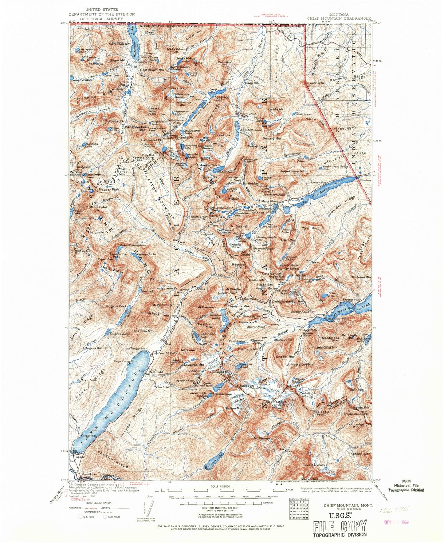
Historical USGS topographic map of Chief Mountain in the state of Montana. Scale: 1:125000. Print size: 18" x 24"
This map was published in 1938 and is in the following counties: Flathead, Glacier.
The map contains contour lines, roads, rivers, towns, streams, and lakes. Printed on high-quality waterproof paper with UV fade-resistant inks.
Contains the following named places: Lewis Range, Pumpelly Glacier, Rogers Peak, Preston Park, Stanton Mountain, Apikuni Creek, Apikuni Flat, Ahern Creek, Ahern Glacier, Ahern Pass, Ahern Peak, Alder Creek, Allen Creek, Allen Mountain, Almost-a-Dog Mountain, Altyn Peak, Anaconda Peak, Angel Wing, Apikuni Falls, Apikuni Mountain, Arrow Lake, Atsina Falls, Atsina Lake, Avalanche Basin, Avalanche Campground, Avalanche Creek, Avalanche Lake, Avalanche Trail, Baring Creek, Baring Falls, Bear Mountain, Bear Mountain Point, Belly River Ranger Station, Bench Lake, Big Drift, Bird Woman Falls, Bishops Cap, Blackfoot Glacier, Blackfoot Mountain, Boulder Ridge, Boulder Ridge Trail, Boundary Creek, Mount Brown, Camas Creek Trail, Camas Lake, Camas Ridge, Camp Creek, Campbell Mountain, Mount Cannon, Canyon Creek, Carcajou Lake, Cassidy Curve, Cataract Creek, Cataract Mountain, Cathedral Peak, Cattle Queen Creek, Chaney Glacier, Chief Mountain, Port of Chief Mountain, Citadel Mountain, Citadel Peaks, Cleveland Creek, Mount Cleveland, Continental Creek, Cosley Lake, Cosley Lake Cutoff Trail, Cosley Ridge, Cracker Flats, Cracker Lake, Cracker Lake Trail, Cracker Mine, Crowfeet Mountain, Cutoff Trail, Dawn Mist Falls, Dead Horse Point, Deadwood Falls, Dusty Star Mountain, Dutch Lakes, Dutch Ridge, East Flattop Mountain, Elizabeth Lake, Lake Evangeline, Falling Leaf Lake, Fifty Mountain Shelter Cabin, Fishercap Lake, Flattop Creek, Flattop Mountain, Flattop Mountain Trail, Floral Park, Florence Falls, Fusillade Mountain, Gable Mountain, Gable Pass, Gable Pass Trail, Mount Geduhn, Gem Glacier, Glacier Wall, Glenns Lake, Goat Haunt Lake, Goat Haunt Mountain, Goat Lake, Goat Mountain, Going-to-the-Sun Mountain, Going-to-the-Sun Point, Golden Stairs, Mount Gould, Governor Pond, Grace Lake, Granite Park, Granite Park Trail, Grinnell Creek, Grinnell Falls, Grinnell Glacier, Grinnell Glacier Trail, Grinnell Lake, Grinnell Point, Mount Grinnell, Gros Ventre Falls, Gunsight Lake, Gunsight Pass, Hanging Gardens, Harrison Glacier, Haystack Butte, Haystack Creek, Heavens Peak, Heavy Runner Mountain, Helen Lake, Helen Lake Trail, Mount Henkel, Hidden Creek, Hidden Falls, Hidden Lake, Hidden Lake Pass, Hidden Lake Trail, Highline Trail, Hudson Bay Creek, Iceberg Creek, Iceberg Lake, Iceberg Lake Trail, Iceberg Notch, Iceberg Peak, Ipasha Falls, Ipasha Glacier, Ipasha Lake, Ipasha Peak, Jackson Glacier, Jackson Glacier Trail, Mount Jackson, Lake Janet, Johns Lake, Josephine Mine, Lake Josephine, Jule Creek, Kaina Creek, Kaina Mountain, Kaina Lake, Kennedy Lake, Kipp Creek, Mount Kipp, Kootenai Creek, Kootenai Lakes, Kootenai Pass, Kootenai Peak, Lee Ridge, Little Chief Mountain, Little Matterhorn, Logan Creek, Logan Glacier, Logan Pass, Mount Logan, Longfellow Creek, Longfellow Peak, Lost Lake, Lunch Creek, Mahtotopa Mountain, Many Falls Trail, Many Glacier, Many Glacier Entrance Station, Margaret Lake, Mary Baker Lake, Matahpi Peak, McDonald Creek Trail, McDonald Falls, McPartland Mountain, Medicine Owl Creek, Mount Merritt, Miche Wabun Falls, Miche Wabun Glacier, Miche Wabun Lake, Miche Wabun Peak, Mineral Creek, Mirror Pond, Mokowanis Cascade, Mokowanis Lake, Mokowanis River, Mokowanis Shelter Cabin, Monument Falls, Moose Country Pond, Morning Eagle Falls, Mount Brown Lookout, Nahsukin Lake, Natahki Lake, Natoas Peak, Norris Mountain, North Boundary Trail, North Fork Belly River Trail, North Swiftcurrent Glacier, Oberlin Falls, Mount Oberlin, Old Sun Glacier, Olson Creek, Olson Mountain, Otatso Lake, Otokomi Lake, Otokomi Mountain, Packers Roost, Paiota Falls, Papoose, Pass Creek, Paul Bunyans Cabin, Piegan Falls, Piegan Glacier, Piegan Mountain, Piegan Pass, Piegan Pass Trail, Poia Lake, Pollock Mountain, Porcupine Lookout, Porcupine Ridge, Ptarmigan Creek, Ptarmigan Falls, Ptarmigan Lake, Ptarmigan Trail, Ptarmigan Tunnel, Ptarmigan Wall, Pyramid Creek