MyTopo
Historic 1919 Chiricahua Arizona 30'x30' Topo Map
Couldn't load pickup availability
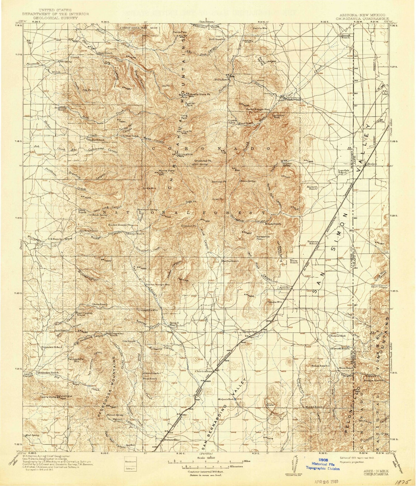
Historical USGS topographic map of Chiricahua in the state of Arizona. Scale: 1:125000. Print size: 17" x 24"
This map was published in 1919 and is in the following counties: Cochise, Hidalgo.
The map contains contour lines, roads, rivers, towns, streams, and lakes. Printed on high-quality waterproof paper with UV fade-resistant inks.
Contains the following named places: Anita Park, Baker Canyon, Bar Boot Ranch, Barfoot Lookout, Barfoot Park, Barfoot Peak, Bates Tank, Bathtub Forest Camp, Bear Canyon, Big Bend Creek, Black Mountain, Blacksmith Tunnel, Blevins Draw, Bootlegger Saddle, Boss Ranch, Boundary Tank, Box Canyon, Bruno Canyon, Bruno Peak, Brushy Canyon, Brushy Canyon, Brushy Creek, Buck Creek, Buckskin Saddle, Buena Vista Peak, Bumblebee Tank, Castle Dome, Castle Dome Ranch, Cathedral Rock, Cave Creek, Cave Creek Canyon, Centella Point, Chiricahua Mountains, Chiricahua Peak, Cima Park, Cima Ranger Station, Cochise Mine, Concrete Tank, Cottonwood Canyon, Cottonwood Creek, Crescent Tank, Cypress Forest Camp, Darnell Peak, Dart Ranch, Davis Mountain, Deep Well Canyon, Deer Creek, Devils Canyon, Dobson Peak, Downing Pass, East Whitetail Creek, El Tigre Mine, Erickson Peak, Erickson Ridge, Fairchild Ranch, Fife Canyon, Fife Peak, Fife Saddle, Fitch Corral, Flys Park, Flys Peak, Garfield Peak, Geronimo Surrender Site, Green Canyon, Grey Tunnel, Halfmoon Valley, Hands Pass, Harris Mountain, Headquarters Windmill, Herb Martyr Forest Camp, Hermitage Forest Camp, High Lonesome Canyon, Hilltop, Hoovey Canyon, Horsefall Canyon, Horseshoe Canyon, Horseshoe Pass, Hughes Tank, Hunt Canyon, Hunt Canyon, Ida Peak, Idlewilde Forest Camp, J Bar A Ranch, Jack Wood Canyon, Jack Wood Pass, Jesse James Canyon, Jhus Canyon, Jhus Horse Saddle, Joe Glenn Ranch, John Hands Picnic Ground, John Long Canyon, Jones Peak, Jones Ridge, Junction Saddle, Kambitsch Tank, Kasper Tunnel, Krentz Ranch, Lamberson and Riggs Ranch, Lead Lily Shaft, Licklog Tank, Limestone Mountain, Little Jesse James Canyon, Long Park, MacKey Canyon, MacKey Tank, Malpais Tank, May Day Peak, Mesa Draw, Middle Witch Canyon, Monkey Tank, Monte Vista Peak, Mormon Canyon, Morse Canyon, Morse Canyon Campground, Mud Springs Ranch, Mulberry Canyon, Natural Tanks, North Bruno Canyon, Pothole Canyon, North Fork Horsefall Canyon, North Fork Rucker Canyon, North Ward Canyon, North Witch Canyon, OK Ranch, Oak Ranch, Onion Creek, Onion Saddle, Owl Creek, Packsaddle Mountain, Paradise, Paramore Crater, Pedregosa Mountains, Pine Canyon, Pine Gulch, Pinery Canyon, Pinery Canyon Campground, Pole Bridge Canyon, Portal, Portal Peak, Portal Ranger Station, Pothole Peak, North Fork Canyon, Price Canyon, Pridham Canyon, Paint Rock, Raspberry Ridge, Rattle Rock Saddle, Rattlesnake Canyon, Rattlesnake Peak, Red Rock Canyon, Rhem Tunnel, Rieder Tunnel, Riggs Tank, Rock Canyon, Rock Creek, Rock Tank, Round Park, Round Valley, Roush Ranch, Rucker Canyon, Rucker Canyon Ranch, Rucker Forest Camp, Rucker Lake, Rucker Ranger Station, Rustler Canyon, Rustler Park, Sage Peak, Sanders Peak, Saulsbury Canyon, Saulsbury Saddle, Sentinel Peak, Shake Gulch, Shaw Peak, Silver Creek, Silver Peak, Silver Prince Mine, Skeleton Canyon, Snure Ranch, Snowshed Peak, Snowshed Trail, South Bruno Canyon, South Fork Cave Creek, South Fork Forest Camp, South Fork Skeleton Canyon, South Witch Canyon, Squaw Mountain, Stanford Canyon, Starvation Canyon, Stewart Forest Camp, Sulphur Draw, Sulphur Peak, Sunny Flat Picnic Ground, Sunset Peak, Swede Peak, Sycamore Canyon, Tex Canyon, Tom Ketchum Canyon, Trunk Canyon, Trunk Canyon Tank, Turkey Creek Campground, Turkey Creek Ranger Station, Turkey Park, Turkey Pen Canyon, Turtle Mountain, Twoweeks Spring Canyon, Walnut Canyon, Ward Canyon, West Turkey Creek Campground, Winkler Ranch, Winn Falls, Witch Creek, Bagwell Ranch, Baldridge Tank, Basin Trail Two Hundred Fortyseven, Ben Tank, Big Bend Number One Tank, Big Bend Number Two Tank, Big Tank, Bird Tank, Boot Stock Tank, Bower Tank, Bruno Tank, Brushy Tank, Camp Rucker Campground, Cave Creek Regional Park, Chiricahua Siding Tank, Chiricahua Tank, Cima Saddle, Coal Pit Tank, Coal Pit Tank, Cottonwood Canyon Trail Two Hundred Sixtysix, Cottonwood Circle Two Hundred Thirtythree, Cottonwood Tank, Crest Trail Two Hundred Seventy, Cummings Tank, Davis Tank