MyTopo
Historic 1915 Cholame California 30'x30' Topo Map
Couldn't load pickup availability
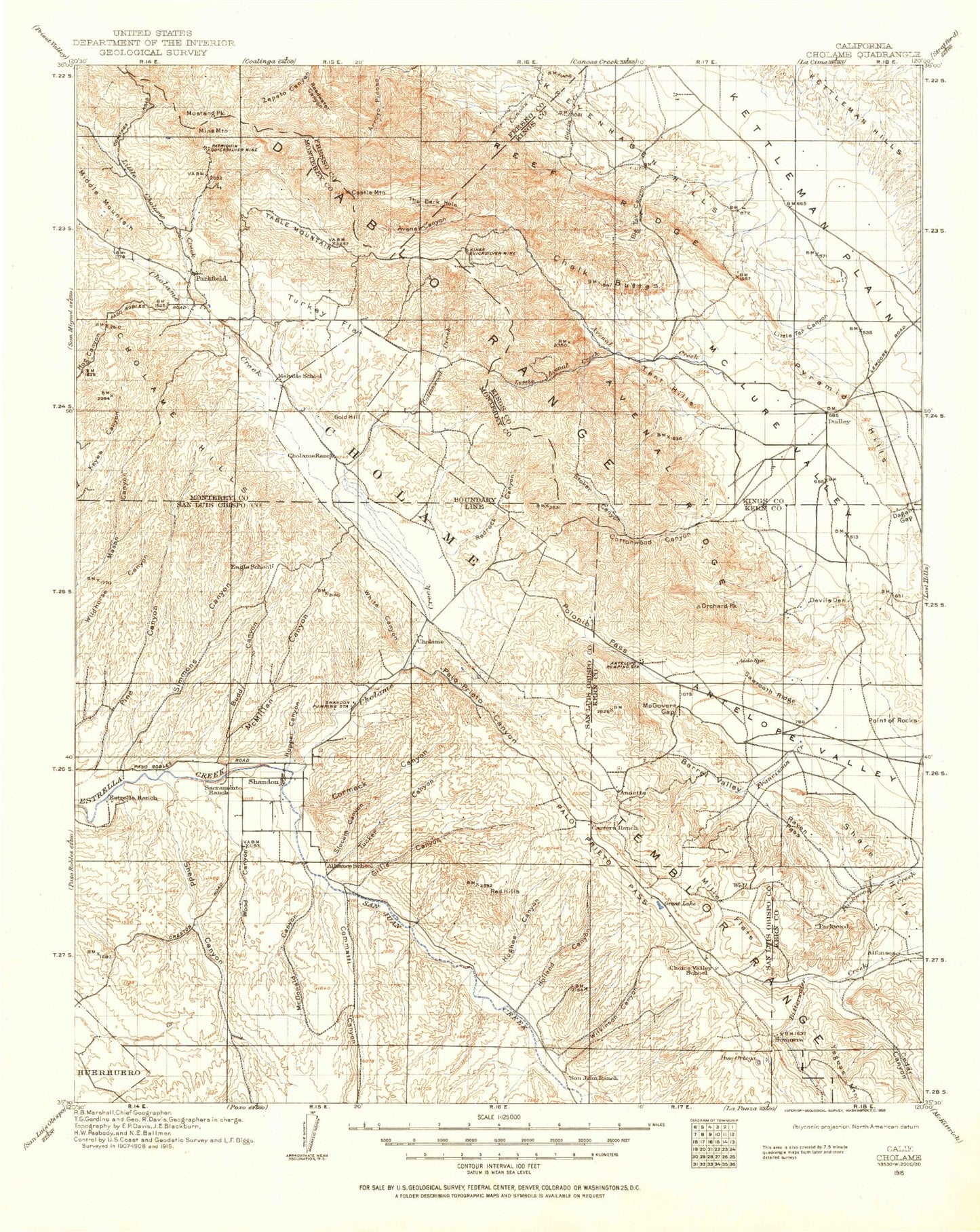
Historical USGS topographic map of Cholame in the state of California. Scale: 1:125000. Print size: 17" x 24"
This map was published in 1915 and is in the following counties: Fresno, Kern, Kings, Monterey, San Luis Obispo.
The map contains contour lines, roads, rivers, towns, streams, and lakes. Printed on high-quality waterproof paper with UV fade-resistant inks.
Contains the following named places: Mount Alice, Andrews Mountain, Birch Lake, Black Mountain, Blake Mine, Blue Star Mines, Brainerd Lake, Cedar Flat, Chalfant Valley, Charlies Butte, Contact Pass, Crooked Creek, Crooked Road Canyon, Disappointment Peak, Elinor Lake, Finger Lake, Grandview Mine, Gray Eagle Mine, Harkless Flat, Mount Jepson, Kid Mountain, Klondike Lake, Marble Canyon, Mather Pass, Middle Palisade Glacier, Mill Canyon, Mollie Gibson Canyon, Mollie Gibson Mines, Montezuma Mine, New Era Mine, North Fork Birch Creek, Palisade Lakes, Papoose Flat, Poverty Hills, Rawson Creek, Red Lake, Sand Canyon, Sanger Meadow, Sangers Slough, Second Lake, Mount Gayley, Soldier Canyon, South Fork Big Pine Creek, South Fork Birch Creek, Southfork Pass, Split Mountain, Squaw Flat, Wunupu Peak, The Narrows, Third Lake, Tinemaha Creek, Tinemaha Lake, Tinemaha Reservoir, Toll House, Upper Basin, Waucoba Mountain, Westgard Pass, Willow Lake, Birch Mountain, Monola, Mount Prater, Mount Bolton Brown, Temple Crag, The Thumb, Mount Tinemaha, Baker Creek, Beer Creek, Big Pine Canal, Big Pine Creek, Big Pine Reservation, Big Pine Lake, Big Prospector Meadow, Birch Creek, Birch Creek, Birch Creek, Bishop Mine, Bishop Creek, Bishop Creek Canal, Black Birch Canyon, Black Canyon, Black Lake, Blanco Mountain, Brockmans Corner, Bucks Peak, Chipmunk Mine, Cleveland Mines, Collins Canal, County Line Hill, Cow Creek, Cowhorn Valley, Coyote Flat, Deadman Canyon, Deep Springs Lake, Deep Springs Valley, Devils Gate, First Falls, First Lake, Fish Slough, Fish Springs Hill, Five Bridge, Ford Flat, Freeman Creek, Fuller Creek, Geiger Canal, Glacier Lodge, Hidden Lake, High Meadows, Iron Mountain, Kings River Trail, Little Cowhorn Valley, Logging Flat, McGee Creek, McMurry Meadows, Mexican Mine, Middle Fork Shannon Canyon, North Fork Crooked Creek, North Fork Shannon Canyon, Onion Creek, Overholtz Mine, Owens River Canal, Owens Valley Ranch, Bishop Reservation, Payson Canyon, Piper Peak, Poleta Canyon, Poleta Mine, Rawson Canal, Red Mountain Creek, Red Peak, Reed Flat, Riche Mine, Roberts Ranch, Roberts Ridge, Rossi Mine, Round Mountain, Sage Flat, Sage Hen Flat, Sage Hen Peak, Shannon Canyon, Campito Mountain, Coldwater Canyon, Dead Horse Meadow, East Fork Coyote Creek, Gunter Creek, Horton Creek, Little Pine Creek, North Fork Big Pine Creek, North McNally Canal, Redding Canyon, Silver Canyon, South Fork Bishop Creek, South Fork Crooked Creek, South Fork Shannon Canyon, South McNally Canal, Southbend Mine, Southern Belle Mine, Stecker Flat, Sugarloaf, Summit Lake, Warren Bench, Warren Lake, Water Canyon, West Fork Coyote Creek, Wilkerson Mine, Yaney Mine, Zurich, North Fork Bishop Creek, Owens Valley, Rolling Green Terrace, Baker Creek Recreation Site, Inyo Camp, Big Pine Triangle County Park, Millpond, Millpond Recreation Area, First Falls Campground, Sage Flat Campground, Camp Bristlecone, Discovery Trail, See Remarks, Schulman Grove Picnic Area, Methuselah Trail, White Mountain Ranger Station, Schober Lane Recreation Site, Rocking K, Inyo National Forest Supervisors Ofiice, Graham Ranch, Poleta Picnic Area, Pinon Campground, Juniper Campground, Fossil Campground, Poleta Campground, Grandview Campground, Pinon Picnic Area, Cedar Flat Entrance Station, Big Pine Creek Campground, Arrastre Meadow, Big Pine, Bishop, Middle Palisade, Cienega Mirth, Crater Mountain, Fish Springs, Red Mountain, Keough Hot Springs, Norman Clyde Peak, Oteys Sierra Village, Palisade Crest, Peterson Mill, Laws, Big Pine Creek Number 2 6-011 Dam, Tinemaha 6-026 Dam, Norman Clyde Glacier, Wilkerson Tract, Big Pine Campground, Birch Campground, Chalk Bluff, Crystal Peak, The Elephant, Fish Springs State Fish Hatchery, Index Hill, Izaak Walton Park, Laws Ditch, Log Canyon, Mendenhall Park, Owens Valley Radio Observatory, Pleasant Valley, Red Hill, Royal Gorge, Saunders Lake, Schulman Grove, Second Falls, Second Falls Campground, Sentinal Peak, Sierra View, Tri-County Fairgrounds, Ancient Bristlecone Pine Forest