
MyTopo
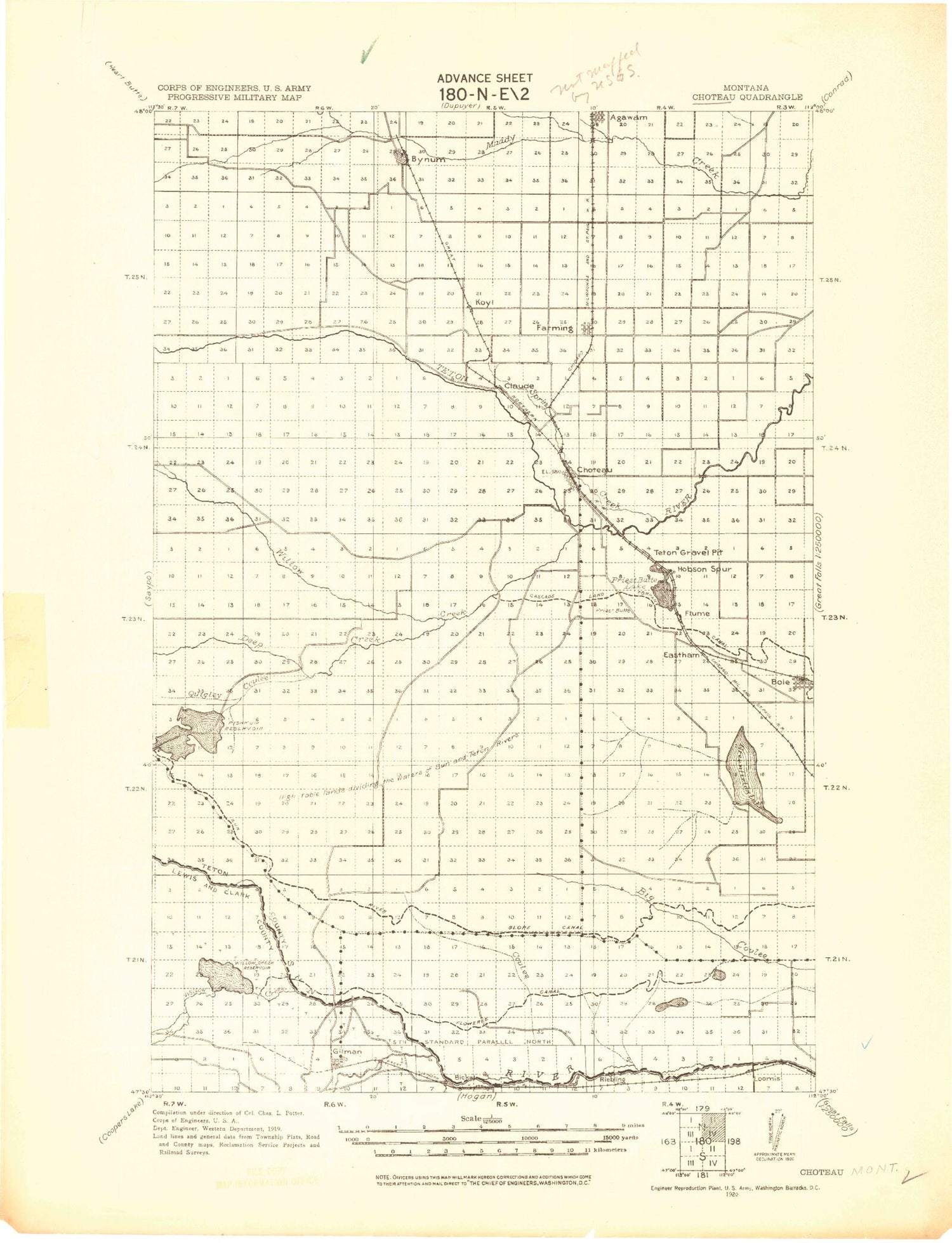
Historic 1920 Choteau Montana 30'x30' Topo Map
Couldn't load pickup availability
Historical USGS topographic map of Choteau in the state of Montana. Scale: 1:125000. Print size: 18" x 24"
This map was published in 1920 and is in the following counties: Cascade, Lewis and Clark, Teton.
The map contains contour lines, roads, rivers, towns, streams, and lakes. Printed on high-quality waterproof paper with UV fade-resistant inks.
Contains the following named places: North Fork Muddy Creek, Agency Creek, Armstrong Ranch, Basin Lake, Big Coulee Drop, Black Ranch, Blixrud Ranch, Bole, Bruce Coulee, Burch Ranch, Burd Hill, Burd Hill Lake, Burton Bench, Bynum, Bynum Reservoir, Bynum Reservoir Ditch, Cascade Canal, Clay Hill, Clemons Coulee, Crary Ranch, Crawford Ranch, Cutting Shed Coulee, D Canal, Davis Lake, Dog Creek, Dougcliff Reservoir, Eagle Point, Eastham Junction, Elbow Coulee, Eldorado Ditch, Erickson Ranch, Eureka Reservoir, Eyraud Lakes, Farmers Ditch, Farmers Reservoir, Floweree Canal, Foster Creek, Freezeout Lake, Gamble Coulee, Glendora Lake, Golden Ridge, Greyn Ranch, Hamilton Ranch, Harvey Lake, Hobson Spur, Hod Main Coulee, Hodgskiss Ranch, Jones Creek, Knaff Ranch, Koyl, Larson Ranch, Lowry, Malone, Maloney Coulee, Meadows Ranch, Miller Creek, Moehler Hill, Monkman Ranch, North Supply Ditch, Nunemaker Coulee, Nunemaker Hill, Peebles Ranch, Peebles Ranch, Perkins Ranch, Poker Butte, Pond Number One, Pond Number Two, Pond Number Three, Priest Butte Lakes, Quigley Coulee, Ralston Gap, Rattlesnake Butte, Reickoff Lakes, Ruebe Ranch, S-T Canal, Sabo Ranch, School Section Coulee, Sevenmile Coulee, Sevenmile Hill, Silve Coulee, Silverman Springs Coulee, Spring Coulee, Spring Creek, Spring Valley Canal, Spring Valley Drop, Sun River Slope Canal, Teton Buttes, Teton Ditch, Teton-Spring Creek Bird Reserve, Trexler Ranch, Turnbull Drop, Upper Turnbull Drop, Watson Flats, Willow Creek, Wolf Coulee, Roundup Coulee, Blacktail Creek, Deep Creek, Fowler Coulee, Hay Coulee, McDonald Creek, North Fork Willow Creek, Pishkun National Wildlife Refuge, Pishkun Reservoir, South Fork Willow Creek, Tin Can Coulee, Ferris Farms Dam, Pishkun Dikes 1 2 3 4 5 6 and 7, Willow Creek Dam, Willow Creek Dike 5, Farmers Coop Canal Company Dam, Farmers Reservoir, Harvey Lake Dam, Harvey Lake, Eureka Reservoir Dam, Choteau Sewage Lagoon Dam, Young Sun Dam, Costly Coulee Reservoir Dam, Freak Out Dam, Jonquil Dam, Brady Lakes Number 4 Dam, Gordan Lightfoot Dam, Young Clemons Dam, Decuman Dam, Deminish Dam, Peach Fuzz Dam, Dougcliff Reservoir Dam, Beale Lake, Carey Butte, Choteau, Dry Creek, Elk Creek, Gilman, Gilman Hill, Hogan Slough, Kirkaldie Canal, Kirkaldie Flats, Loomis Coulee, Meyer Hill, Meyer Lake, North Fork Willow Creek, Riebeling, Split Rock Junction, Spring Creek, Willow Creek, Willow Creek National Wildlife Refuge, Willow Creek Reservoir, Agawam, Farmington, SE NE Section 10 Mine, NW NW Section 11 Mine, SW NW Section 10 Mine, Pearson Ranch, Freezout Lake Wildlife Management Area, Brady Canal, Fabrick Ranch, Pelzman Ranch, Choteau Junction, Miller Colony, New Rockport Colony, Priest Butte, Truchot Hill, Pond Number Six, Pond Number Five, Pond Number Four, Round Lake, Middle Lake, S Canal, Teton County, Arod Lake Fishing Access Site, Bynum Reservoir Fishing Access Site, Eureka Reservoir Fishing Access Site, Pishkun Reservoir Fishing Access Site, Willow Creek Reservoir Fishing Access Site, Harvest States Cooperatives Elevator, General Mills Incorporated Elevator, Egg Mountain, Choteau KOA Kampground, Choteau Park and Campground, Choteau Country Club, Blackfeet and Buffalo Historical Marker, Old Agency on the Teton Historical Marker, Gibson Coulee, Floweree Coulee, Dipping Tank Creek, Delaney Coulee, School Coulee, French Coulee, Crossen Coulee, Anderson Coulee, Road Coulee, Wolf Coulee, South Fork Klingensmith Coulee, North Fork Klingensmith Coulee, Cashman Coulee, South Fork Cashman Coulee, Klingensmith Coulee, Coyote Coulee, Flume, Choteau, Bynum, Sun River Historical Marker, Choteau Division, Fairfield Division, City of Choteau, Teton County Waterfowl Production Area


