
MyTopo
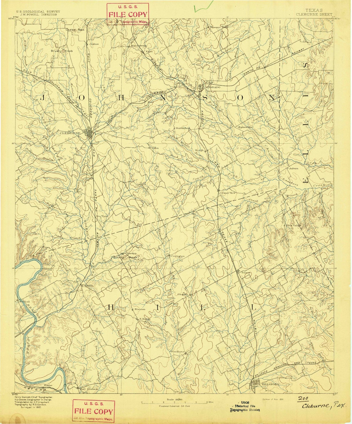
Historic 1891 Cleburne Texas 30'x30' Topo Map
Couldn't load pickup availability
Historical USGS topographic map of Cleburne in the state of Texas. Scale: 1:125000. Print size: 17" x 24"
This map was published in 1891 and is in the following counties: Bosque, Ellis, Hill, Johnson.
The map contains contour lines, roads, rivers, towns, streams, and lakes. Printed on high-quality waterproof paper with UV fade-resistant inks.
Contains the following named places: Adair Spring Branch, Alvarado, Armstrong Creek, Bailey Hollow, Bear Creek, Belnap Creek, Benson Slough, Bluff Mills, Blum, Boggy Branch, Boggy Creek, Boss Branch, Broke Rock, Broke Rock Hollow, Brushy Knob, Brushy Knob, Buffalo Creek, Caddo Peak, Camp Hoblitzelle, Carver Park, Chisholm Trail Park, Cleburne, Coffee Branch, Coleman Creek, Cottonwood Creek, Cottonwood Creek, Cottonwood Creek, Covington, Dam Number 110, Dam Number 37, Dam Number 38, Dam Number 39, Dam Number 40, Dam Number 41, Dam Number 51, Dam Number 52, Dam Number 53, Dam Number 54, Dam Number 55, Dam Number 56, Dam Number 59, Dam Number 60, Dam Number 61, Dam Number 62, Dam Number 72, Dam Number 74, Darr Branch, Dry Branch, East Buffalo Creek, East Fork Chambers Creek, East Fork Weakly Branch, Elm Hollow, Falls Branch, Fish Spring Branch, Fishermans Paradise, Gourd Neck Branch, Grandview, Haley Branch, Ham Creek, Ham Creek Park, Haw Hollow, Hay Hollow, Hayden Creek, Hillsboro, Hog Creek, Horne Branch, Hulen Park, Hulett Hollow, Indian Lodge, Itasca, Joshua, Keene, Kimball Bend, Kimball Bend Park, Lakeside Village, Little Bear Creek, Little Hackberry Creek, Live Oak Resorts, Lockett Branch, Lovelace, Lovelace Creek, Majors Branch, Martin Branch, Mayfield, Maypearl, McAnear Creek, Mesquite Branch, Morgan Lakeside Park, Mustang Creek, Nolan River, Nolan River Park, North Fork South Fork Chambers Creek, Oak Hill, Old Fort Park, Opossum Hollow, Osceola, Owl Hollow, Parker, Parker Creek, Phelps Creek, Pilot Branch, Plowman Creek, Plowman Creek Park, Powelldale Mountains, Raymond Creek, Retreat, Rio Vista, Robinson Bluff, Robinson Branch, Rock Creek, Rock Tank Creek, Spring Branch, Steele Creek Park, Steiner Valley, Steiner Valley Park, Town Branch, Turkey Creek, Valley Branch, Venus, Wallace Branch, Weakly Branch, West Buffalo Creek, West Fork Nolan River, West Fork Weakly Branch, West Nolan Creek, West Prairie, West Soap Creek, White Bluff, Willow Creek, Woodbury, Island Creek, Itasca Creek, Katy Lake, Mesquite Creek, Middle Fork South Fork Chambers Creek, Pecan Creek, South Fork South Fork Chambers Creek, Steele Creek, Carls Corner, Antioch, Auburn, Blanton, Burton, Cuba, Derden, Egan, Files Valley, Griffith, Grub Hill, Happy Hill, Huron, Lakenon, Lebanon, Lone Willow, Marystown, Midway, Mountain Peak, Mountain View, Pleasant Point, Red Hill, Sand Flat, Ward, Woodrow, Johnson County, Riverview Golf Club, Soil Conservation Service Site 61 Dam, Soil Conservation Service Site 61 Reservoir, Soil Conservation Service Site 60 Dam, Soil Conservation Service Site 60 Reservoir, Soil Conservation Service Site 59 Dam, Soil Conservation Service Site 59 Reservoir, Soil Conservation Service Site 54 Dam, Soil Conservation Service Site 54 Reservoir, Soil Conservation Service Site 53 Dam, Soil Conservation Service Site 53 Reservoir, Soil Conservation Service Site 52 Dam, Soil Conservation Service Site 52 Reservoir, Soil Conservation Service Site 51 Dam, Soil Conservation Service Site 51 Reservoir, Soil Conservation Service Site 62 Dam, Soil Conservation Service Site 62 Reservoir, Soil Conservation Service Site 55 Dam, Soil Conservation Service Site 55 Reservoir, Soil Conservation Service Site 50 Dam, Soil Conservation Service Site 50 Reservoir, Soil Conservation Service Site 56 Dam, Soil Conservation Service Site 56 Reservoir, Hillsboro Lake Park Dam, Soil Conservation Service Site 67a Dam, Soil Conservation Service Site 67a Reservoir, Soil Conservation Service Site 72 Dam, Soil Conservation Service Site 72 Reservoir, Soil Conservation Service Site 65a Dam, Soil Conservation Service Site 65a Reservoir, Soil Conservation Service Site 67b Dam, Soil Conservation Service Site 67b Reservoir, Soil Conservation Service Site 74 Dam, Soil Conservation Service Site 74 Reservoir, Soil Conservation Service Site 41 Dam, Soil Conservation Service Site 41 Reservoir, Soil Conservation Service Site 40 Dam, Soil Conservation Service Site 40 Reservoir, Soil Conservation Service Site 39 Dam, Soil Conservation Service Site 39 Reservoir, Soil Conservation Service Site 37 Dam, Soil Conservation Service Site 37 Reservoir, Soil Conservation Service Site 72-A Dam, Soil Conservation Service Site 72-A Reservoir, Soil Conservation Service Site 38 Dam, Soil Conservation Service Site 38 Reservoir, Gilmer and Walker Lake Dam, Gilmer and Walker Lake, Soil Conservation Service Site 78 Dam, Soil Conservation Service Site 78 Reservoir, Soil Conservation Service Site 75b Dam, Soil Conservation Service Site 75b Reservoir, Soil Conservation Service Site 53 Dam, Soil Conservation Service Site 53 Reservoir, Soil Conservation Service Site 54 Dam, Soil Conservation Service Site 54 Reservoir, Soil Conservation Service Site 55 Dam, Soil Conservation Service Site 55 Reservoir, Soil Conservation Service Site 77 Dam, Soil Conservation Service Site 77 Reservoir, Wilemon Lake Dam, Wilemon Lake, Soil Conservation Service Site 10 Dam, Soil Conservation Service Site 10 Reservoir, Soil Conservation Service Site 9 Dam, Soil Conservation Service Site 9 Reservoir, Camp Hobilitzelle Lake Dam, Camp Hobilitzelle Lake, Crossroads Lake Dam, Crossroads Lake, Cement Plant Dam, Cement Plant Lake


