MyTopo
Historic 1895 Cleveland Tennessee 30'x30' Topo Map
Couldn't load pickup availability
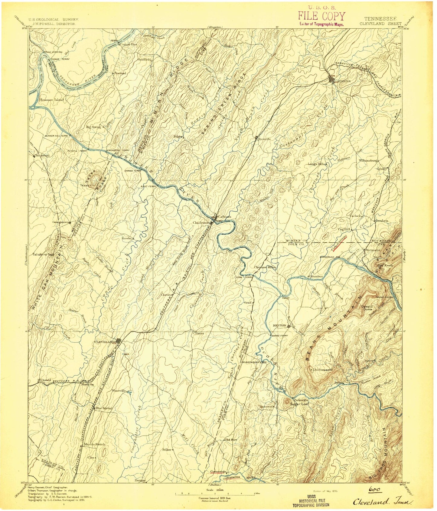
Historical USGS topographic map of Cleveland in the state of Tennessee. Scale: 1:125000. Print size: 17" x 24"
This map was published in 1895 and is in the following counties: Bradley, Hamilton, McMinn, Meigs, Polk, Rhea.
The map contains contour lines, roads, rivers, towns, streams, and lakes. Printed on high-quality waterproof paper with UV fade-resistant inks.
Contains the following named places: Mooneyham Branch, Shears Branch, Big Frog Wilderness, Goodfield Valley, Guthrie Branch, Left Fork Rock Creek, Liberty Branch, McMinn Ridge, North Fork Harris Creek, Shears Branch, Sherwood Forest, Shiloh Ridge, Shingle Hollow, Shoal Creek, Short Creek, Simpson Pond, Sina Branch, Sivils Bluff, Sivils Branch, Sloan Gap, Smith Branch, Smith Ridge, Snyder Branch, Sokey Branch, Sokey Creek, South Fork Harris Creek, South Mouse Creek, Spring Branch, Spring Creek, Spring Creek Ridge, Squire Liner Hollow, Stillhouse Hollow, Stone Lake, Suburban Hills, Sugar Grove, Sugarloaf Knob, Swafford Knob, Sweetwater Valley, Taylor Branch, Tellico Hills, Texas Knobs, Thomas Branch, Underwood Branch, Valley View Hollow, Waldrop Store, Walker Branch, Walker Valley, Wall Hollow Branch, Ward Bluff, Waterville, Watt Heights, Weatherly Switch, Webb Lake, West Fork Gunstocker Creek, White Hollow, White Oak Valley, Wildwood Lake, Wilkins Spring Branch, Willis Springs, Wilson Bend, Wolf Branch, Wolf Pond, Wolf Ridge Trail, Yellow Stand Lead, Ziegler Slough, Rogers Creek Wildlife Management Area, Able Ridge, Agency Creek, Allen Branch, Allen Branch, Allen Mill Fork, Allford Branch, Alta Vista, Anderson Spring Branch, Annadale, Anstis Lake, Apison Fork, Apison Ridge, Armstrong Bend, B and B Marina, Baker Creek Inlet, Ball Play Creek, Barger Knob, Barley Branch, Bates Bend, Baugh Spring, Beaverdam Branch, Bedwell Branch, Beech Springs Branch, Beeler Ridge, Ben Liner Hollow, Beta Branch, Bethea Pond, Bigsby Creek, Bird Branch, Bird Hollow, Black Branch, Black Fox Creek, Black Fox Valley, Blackburn Branch, Blackburn Creek, Blackburn Ridges, Blazer Lake, Blue Spring Branch, Blue Springs Branch, Blue Springs Ridge, Blue Springs Valley, Blythe Ferry Goose Management Area, Bohannon Addition, Boyd Branch, Breeden Pond, Brewer Addition, Broad Shoals, Brown Branch, Brush Creek, Brymer Creek, Buckhorn Creek, Bulldog Branch, Burdette Ridge, Burlington Heights, Butler Knobs, Calhoun, Camp Cherokee, Camp Ocoee, Camp Wasson, Candies Creek Ridge, Candies Creek Valley, Carson Creek, Carter Branch, Cave Spring Branch, Cedar Springs Branch, Chatton Spring Branch, Clear Branch, Cleveland, Climer, Cloud Branch, Coile, Colbaugh Hollow, Coldwater Branch, Copper Branch, Cotton Port Ridge, Cotton Port Wildlife Management Area, Cove Field Branch, Crawford Branch, Crooked Branch, Davis Bend, Davis Branch, Davis Lake, Dockery, Dogwood Hollow, Drumgool Creek, Dry Branch, Dry Creek, Dry Valley, Durham Hollow, Eads Bluff, East Cleveland, East View, Edgewater, Elder Hollow, Eledge Ridge, Eureka, Mount Evil, Fairview, Fairview, Fillauer Branch, Fillauer Lake, Fisher Hollow, Five Mile Branch, Flag Pond, Fork Ridge, Fork Ridge, Fuller Slough, Garrison Bluff, Gee Branch, Georgetown, Gettys Ridge, Gholdston Slough, Gilbert Hollow, Gilbreath Ridge, Gillespie Bend, Good Hope Branch, Good Hope Slough, Goodfield Creek, Goodman Bluff, Green Meadow, Green Shadow Lake, Gregory Branch, Gunstocker Creek, Hale Hollow Creek, Hambright Bend, Hardin Creek, Hardin Slough, Harris Branch, Harris Creek, Henegar Bluff, Hickory Top, Hicks Branch, Hidden Valley Camp, Hiwassee Island, Hiwassee Slough, Hiwassee Wildlife Refuge, Hooper Slough, Hoot'n Hollow, Hopewell, Hopewell Hollow, Horner Hollow, Horns Creek, Horse Branch, Housley Addition, Humphreys Ridge, Hungry Hollow, Hunt Lake, Hutsell, Idlewild, Indian Creek, Indian Creek Inlet, Ingleside Hill, Jack Branch, Jenkins Branch, Jenkins Ridge, Jersey Meadow Lake, Jewell Bluff, Johns River Hollow, Johnson Branch, Johnson Branch, Johnson Knob, Johnston Campside, Judd Slough, Kelly Hill, Kibble Branch, Kile Lake, Kinser Creek, Knox Park, Lake Richland Boat Dock, Lead Mine Ridge