MyTopo
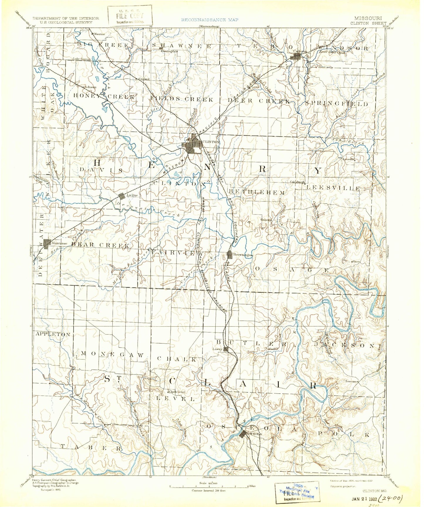
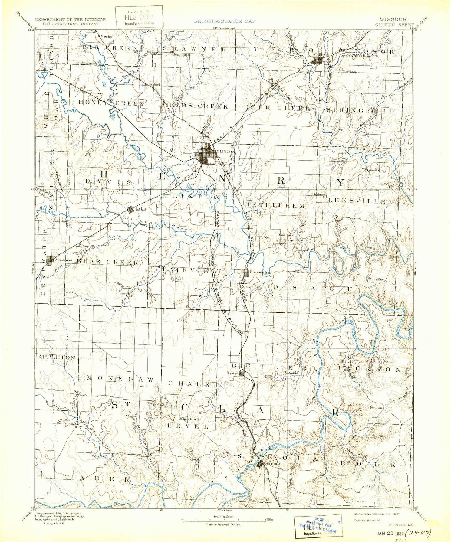
Historic 1894 Clinton Missouri 30'x30' Topo Map
Couldn't load pickup availability
Historical USGS topographic map of Clinton in the state of Missouri. Scale: 1:125000. Print size: 17" x 24"
This map was published in 1894 and is in the following counties: Benton, Henry, Hickory, St. Clair.
The map contains contour lines, roads, rivers, towns, streams, and lakes. Printed on high-quality waterproof paper with UV fade-resistant inks.
Contains the following named places: Barker Creek, Bear Creek, Big Creek, Brownington, Brush Creek, Brushy Creek, Calhoun, Camp Creek, Cedar Creek, Clear Creek, Clinton, Club Lake, Coal Creek, Crow Branch, Deepwater, Deepwater Creek, Deer Creek, Dillion Creek, Duck Creek, Dumpling Creek, East Fork Honey Creek, East Fork Tebo Creek, Ford Branch, George Branch, Hartwell, Hilty Mine, Hilty Mine, Holwell Branch, Honey Creek, Huntingdale, Johnson Mine, La Due, Lewis, Middle Fork Tebo Creek, Montrose, Morris Mine, Mound Springs Creek, Mount Zion, Harrelson Creek, Nelson Creek, Old Channel South Grand River, Redding Mine, Rose Creek, Sand Creek, Sparrow Creek, The Mound, Town Creek, Trap Branch, Wade Creek, Wastell Mine, West Fork Tebo Creek, White Oak Creek, White Oak Creek, Willow Branch, Willow Branch, Coal, Fields Creek, Fishing Creek, Granddaddy Creek, Harvey, Leesville, Sparrow Foot Creek, Garland, Pretty Bob Creek, Cottonwood Branch, Marshall Creek, Yolo, North Clinton, Sparrow, Hortense, Alberta, Gaines, Livingston, Maurine, Quarles, Roseland, Tightwad, Eastgate Shopping Center, Poague State Wildlife Area, Cooper Creek Public Use Area, Sparrowfoot Public Use Area, Cooper Creek Public Use Area, Windsor Crossing Public Use Area, Montrose Conservation Area, Leesville State Wildlife Management Area, Tebo Islands State Wildlife Management Area, Urich State Wildlife Area, Thrush, Brownington State Wildlife Area, Finey, Jackson Branch, Udo Bend, Delmar, Baker Branch, Baldwin Lakes, Bear Creek, Beers Lake, Berry Bend, Big Muddy Creek, Big Otter Creek, Blalock Hollow, Briley Creek, Browns Ford, Broyles Branch, Brush Creek, Butler Hollow, Buzzards Roost, Camp Branch, Camp Grandview, Carey Branch, Cedar Point, Chalk Level, Chloe, Clammer Branch, Collins Hollow, Cooper Creek, Debeker Hollow, Ditty Creek, Finley Creek, Gallinipper Creek, Garrison Hollow, Gilbert Lakes, Golden Ridge, Grass Hill, Hagen Hill, Happy Hollow, Harper, Harris Bend, Hay Creek, Horse Hollow, Horseshoe Bend, Iconium, Iuka Springs, Johnson City, Lilleys Island, Little Monegaw Creek, Little Muddy Creek, Little Otter Creek, Lowry City, Millers Island, Monegaw Creek, Monegaw Springs, Moore Hollow, Ninnescah Park, Ogles Hill, Ohio, Osceola, Panther Creek, Reader Hill, Reese Hollow, Reid Creek, Reynolds Hollow, Ricky Creek, Robins Hill, Rock of Ages Bluff, Rooke Hollow, Sac River, Salt Creek, Silver Creek, Simms Creek, Slough Branch, Smith Bend, Snyder Hollow, South Fork Wright Creek, Spill Creek, Spring Lake, Suitor Hollow, Taberville, Talley Bend, Turkey Creek, Turkey Hollow, Underwood Hill, Walker Island, Walnut Hollow, Weaubleau Creek, Wisener Hollow, Wolf Creek, Wright Creek, Yellow Creek, Youngers Lookout, Crowes Crossing Public Use Area, Brush Creek Public Use Area, H. Roe Bartle Scout Reservation, Whitley Bend, Square Prairie, Western Ozarks, Copeland, Taberville Public Access, Turkey Creek State Wildlife Area, Kibbie Hill, Clubhouse Hill, Fox Run, Dave Rock Natural Area, Gallinipper Creek State Wildlife Area, Sac-Osage State Wildlife Area, Weaubleau Creek State Wildlife Area, Goose Lake, Harry S Truman Reservoir, Montrose Lake, Re Mansfield Dam, Damascus, Henry County, Saint Clair County, Berry Bend Public Use Area, Goose Lake Dam, Williams Lake Section 36 Dam, Williams Lake, E Burns Dam, Whitaker Dam, Whitaker Lake, Nettelblad Lake Dam, Montrose Lake Dam, Tebo Freshwater Lake Dam, Number 111 Lake, O'Dell Lake Dam, O'Dell Lake, Beaty Ranch Lake Dam, Beaty Lake, Ackley Lake Dam, Ackley Lake, Dickey Lake Dam, June-Bug Lake, Williams Lake Section 35 Dam, Hinton Lake Dam, White Lake Dam, Kerns Lake Dam, Kerns Lake, Barber Lake Dam, Noland Lake Dam, Hutcherson Lake Dam, Dody Lake Dam, Wall Lake Dam, Stotts Lake Dam, Clary Lake Dam, Haverland Lake Dam, Corbin Lake Dam