MyTopo
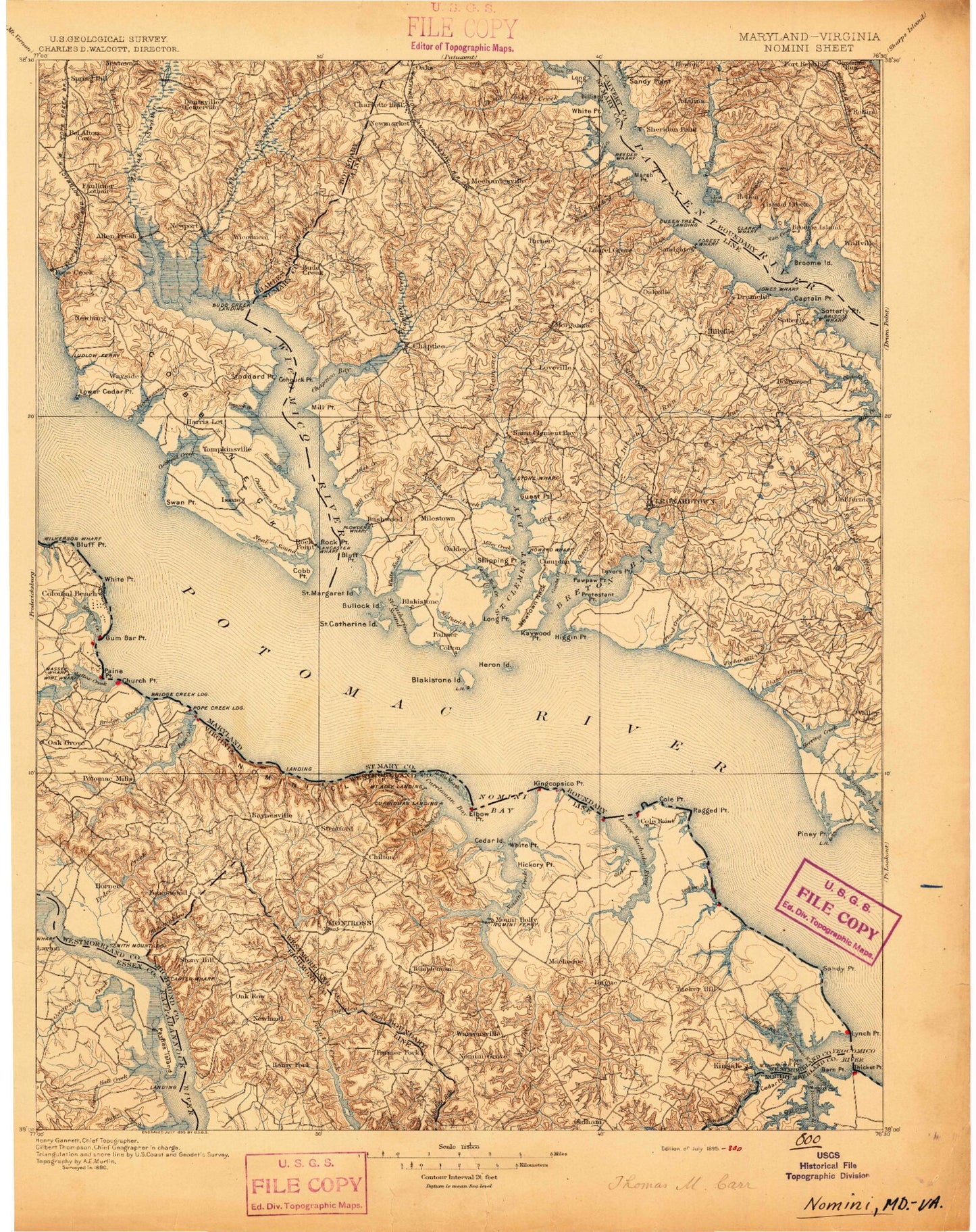
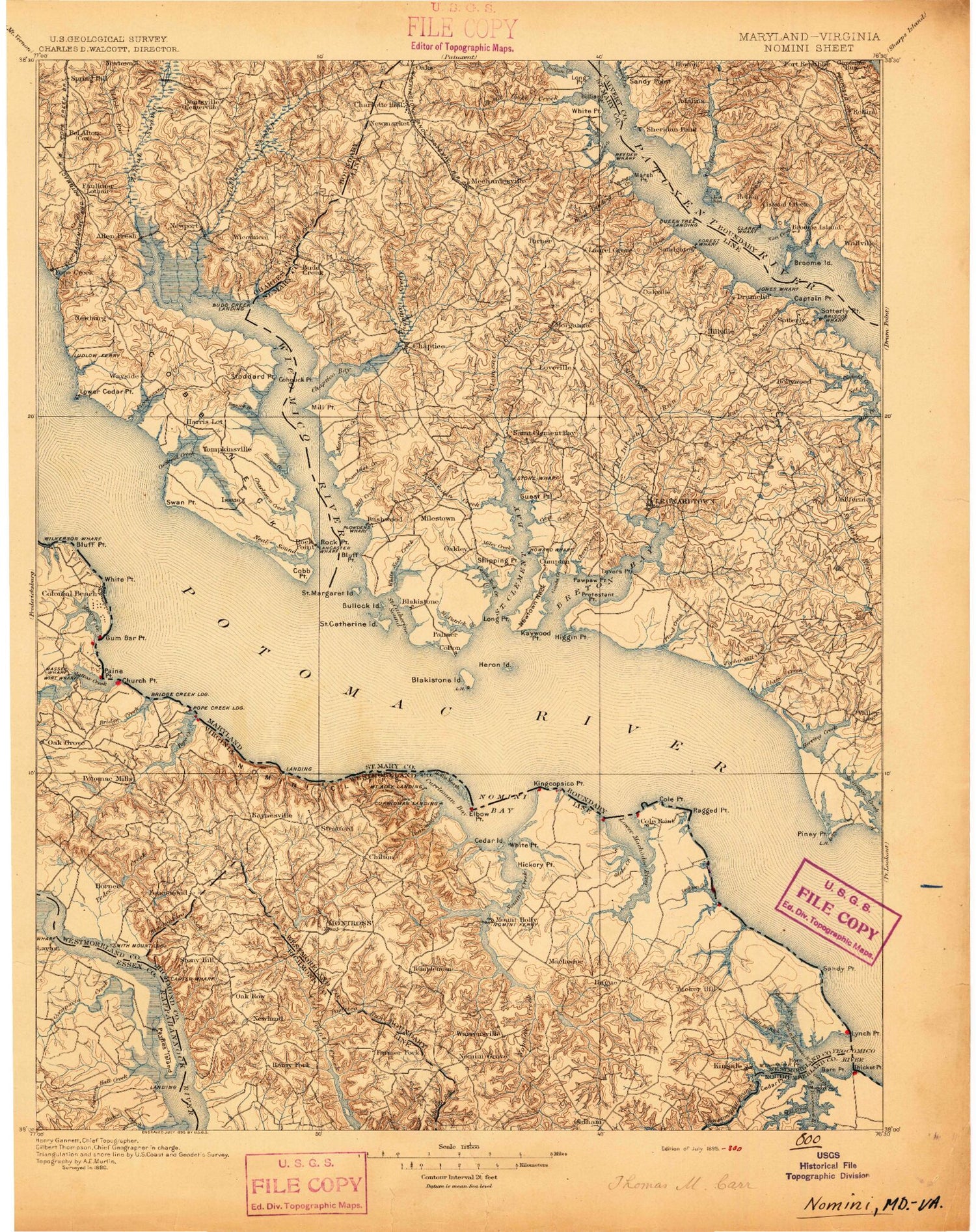
Historic 1895 Colonial Virginia 30'x30' Topo Map
Couldn't load pickup availability
Historical USGS topographic map of Colonial in the state of Virginia. Scale: 1:125000. Print size: 16" x 24"
This map was published in 1895 and is in the following counties: Calvert, Charles, Essex, King George, Northumberland, Richmond, St. Mary's, Westmoreland.
The map contains contour lines, roads, rivers, towns, streams, and lakes. Printed on high-quality waterproof paper with UV fade-resistant inks.
Contains the following named places: Haulover Inlet, Aimes Creek, Allen Point, Antioch Branch, Asparagus Point, Bailey Swamp, Barn Point, Barnes Creek, Barnes Point, Beales Mill Run, Beales Millpond, Beales Wharf, Beaverdam Creek, Belfield Creek, Bettys Neck, Bettys Pond, Beverly Marsh, Beverly Marsh Creek, Big Meadow Run, Big Meadow Trail, Black Swamp, Blackbeard Pond, Blake Point, Blandfield Point, Bluff Point, Bonum Creek, Booths Bend, Bottoms Neck, Bowen Swamp, Boyse Point, Branson Cove, Bransons Point, Brick Hill Creek, Bridge Creek, Bridges Creek, Brockenbrough Creek, Browns Cove, Bryant Swamp, Buckner Creek, Buena Vista Branch, Bull Neck, Bumbers Branch, Bundys Swamp, Burnett Creek, Burnt House, Burnt House Cove, Burnt House Point, Bushfield Bend, Cabin Point, Cabin Point Creek, Camp Hull Springs, Canal Swamp, Canal Swamp, Carters Wharf, Carys Point, Cedar Island, Cedar Point, Chandlers Mill Run, Chantilly Branch, Cherry Grove Creek, Cherry Orchard Point, Cherry Point Neck, Chrystal Lake, Church Point, Church Point, Clifton Branch, Cold Harbor Creek, Colemans Creek, Coles Neck, Coles Point, Columbia Cove, Connellee Millpond, Cornish Creek, County Line Fork, Crookhorn Branch, Crow Bar, Crusenberry Meadow, Cupola Point, Currioman Bay, Currioman Creek, Dancing Marsh, Danger Point, Davis Branch, Davis Creek, Deep Point, Devils Reach, Dickson Point, Digwood Swamp, Doctor Point, Doyle Cove, Drum Bay, Drum Cove, Duck Hall Point, Dungan Cove, Dungan Point, Elbow Point, Farmers Hall Creek, Finchs Branch, Flamstead Hill Swamp, Fones Cliffs, Fox Hall Swamp, Fox Point, Gardner Creek, Garlands Creek, George Washington Birthplace National Monument, Glebe Creek, Glebe Harbor, Glebe Point, Goldman Creek, Grandmammy Swamp, Grannys Bar, Grapevine Point, Gravel Run, Great House Point, Great Island, Gum Bar Point, Hall Branch, Hampton Hall Branch, Handpole Creek, Hanley Point, Harrison Point, Haulover Point, Herring Pond, Hester Cove, Hickory Point, High Point, High Point, Hog Point, Hollis Marsh, Horn Point, Horsehead Cliffs, Hutchinson Swamp, Icehouse Point, Island Point, Jackson Creek, Jenkins Cove, Jenkins Point, Jones Branch, Jones Branch, Jones Creek, Jules Creek, Kenna Swamp, Kingcopsico Point, Kings Millpond, Kinsale Branch, Kirk Point, Lawrence Swamp, Lawson Neck, Lee Creek, Linton Point, Little Meadow Run, Lodge Creek, Long Cove, Long Point, Long Pond, Longwood Swamp, Low Point, Lower Machodoc Creek, Lukes Island, Lyell Branch, Lynch Point, Machodoc Neck, Machodoc Neck, Margaret Lee Swamp, Marriner Run, Marshall Creek, Massey Wharf, Matthews Cove, Matthews Point, Mattox Creek, McGuires Wharf, Menokin Bay, Mill Creek, Mill Run, Mill Swamp, Mitchell Run, Monroe Bay, Monroe Creek, Morris Run, Morris Store, Mount Pleasant Branch, Mud Hole Swamp, Mundy Point, Muses Beach, Nanny Sanford Swamp, Narrow Beach, Negro Point, Newtons Mill Run, Newtons Pond, Nomini Bay, Nomini Cliffs, Nomini Creek, North Prong Buckner Creek, Northwest Yeocomico River, Oak Grove, Occupacia Creek, Old Mill Branch, Oldham Run, Omohundra Run, Otterburn Marsh, Oyster Shell Point, Palmer Cove, Palmer Point, Palmers Cove, Palmers Point, Pantico Run, Parham Point, Parker Run, Parkers Creek, Parkers Island, Paynes Island, Paynes Point, Pea Neck, Pea Ridge, Peedee Creek, Peirce Creek, Plumb Point, Point of Point, Poor Jack Creek, Poorhouse Swamp, Popes Creek, Popes Creek Swamp, Porridge Pot, Porters Meadow, Potomac Mills Pond, Potter Branch, Ragged Point, Ragged Point Beach, Reeds Swamp, Reel Point, Robins Grove Point, Rosier Creek, Rouzie Swamp, Ruin Branch, Scates Branch, Scates Millstream