MyTopo
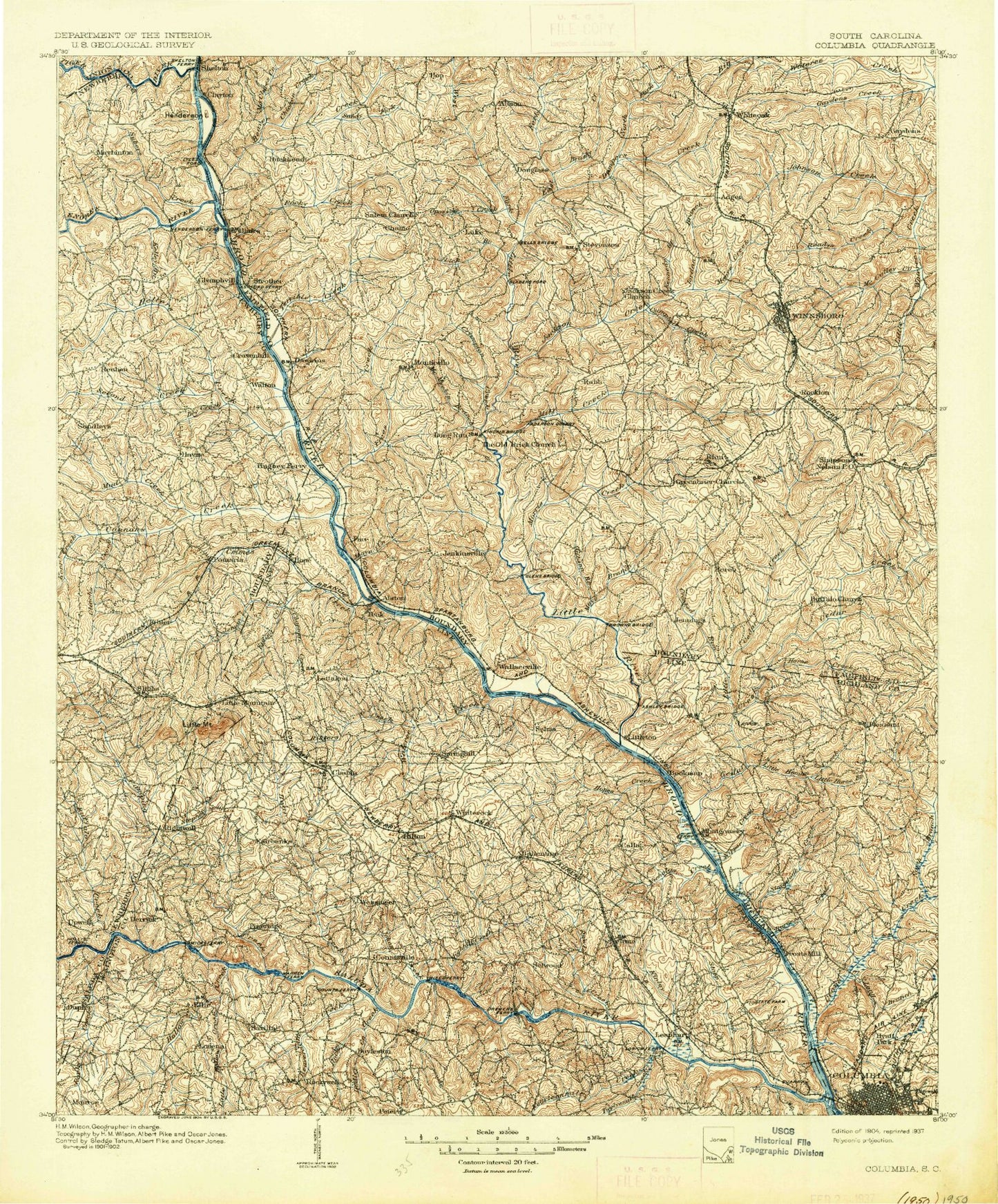
Historic 1904 Columbia South Carolina 30'x30' Topo Map
Couldn't load pickup availability
Historical USGS topographic map of Columbia in the state of South Carolina. Scale: 1:125000. Print size: 17" x 24"
This map was published in 1904 and is in the following counties: Fairfield, Lexington, Newberry, Richland, Saluda, Union.
The map contains contour lines, roads, rivers, towns, streams, and lakes. Printed on high-quality waterproof paper with UV fade-resistant inks.
Contains the following named places: Bear Creek, Beasley Creek, Beaverdam Creek, Beech Creek, Big Branch, Bookman Creek, Bookman Shoals, Boone Creek, Boyd Branch, Brushy Fork Creek, Buffalo Creek, Bundrick Island, Burgess Creek, Camp Branch, Camp Dixon, Camping Creek, Center Creek, Chappel Branch, Clemons Branch, Columbia Canal, Corley Island, Counts Island, Crane Creek, Double Branch, Douglass, Dreher Island, Drew Park, Dry Fork Creek, Eighteenmile Creek, Elkins Creek, Freshley Branch, Gaydens Creek, Gibson Branch, Gladney Branch, Harden Branch, Harrison State Forest, Hickory Island, Hope Creek, Horse Creek, Horse Creek, Horse Creek, Irwin Park, Jennings, Jim Spence Islands, Jollystreet, Jordan Branch, Kennedy Creek, Koon Branch, Lebanon, Little Cedar Creek, Little Hollow Creek, Little Horse Branch, Little Horse Creek, Long Branch, Lorick Branch, Lunch Island, Main Line Ditch, Marshall Park, McCulley Creek, Metz Branch, Mill Creek, Millers Branch, Minton Creek, Moccasin Branch, Moore Creek, Morris Creek, Lake Murray, Mussel Creek, Nicholas Creek, Persimmon Fork, Pinehurst Park, Rawls Creek, Ridgewood Camp, Risters Creek, Robinson Branch, Rock Dam Creek, Rockton, Rocky Branch, Rocky Creek, Rocky Creek, Rocky Point, Russell Creek, Saluda Dam, Senn Branch, Shull Island, Smith Branch, Smith Branch, Snap Branch, Stitt Branch, Stoop Creek, Susannah Branch, Susie Ebert Island, Swygert Branch, Swygert Creek, Twentymile Creek, Wall Creek, Wateree Creek, Waverly Sanitarium, White Oak Branch, Wildhorse Branch, Williams Branch, Winters Pond, Yost Creek, Shimmys Pond, Big Cedar Creek, Bookman, Cedar Creek, Climax, Frost, Montgomery, Ridge Road Crossroads, Wheeland, Billy Dreher Island State Park, Jug Hole, Living Inn, Lominick Point, Buck Branch, Cane Creek, Cannons Creek, Chicken Creek, Crims Creek, Crumpton Creek, Duffs Branch, Fort Wagner Monument, Hellers Creek, Kerr Creek, Lick Branch, Little River, Mud Creek, Opossum Branch, Parr Shoals Dam, Peters Creek, Quarters Branch, Reedy Branch, Sandy Fork, Second Creek, Stevenson Park, Strother, Subers Creek, Monticello Reservoir, Rocky Branch Hunt Camp, Scenic Area Hunt Camp, Alston, Ballentine, Ballentine Landing, Belmont, Brice Hill, Challedon, Chapin, Dawkins, Denny Terrace, Eau Claire, Fairview, Glymphville, Grenadier, Hollow Creek, Irmo, Lake Murray Shores, Little Mountain, Littleton, Macedonia, Maybinton, Monticello, Munster, Nursery Hill, Providence, Red Star, Rion, Rock Hill, Slighs, White Oak, White Rock, Whitehall, Winnsboro Mills, Woodland Hills, Anderson Quarry, Buck Shoals, Busbys Shoals, Chapels Shoals, Griffins Shoal, Hunts Branch, Mile Branch, Neckleys Creek, Old Buckhead, Pearsons Island, Powells Shoal, Ready Creek, Rock Creek, Rocky Branch, Wallaceville, White Oak Conference Center, White Oak Historic District, Mullers Lake D-0279 Dam, Mullers Lake, Smiths Pond D-0541 Dam, Smith Pond, South Carolina Noname 40036 D-0271 Dam, Keels Lake D-0293 Dam, Keels Lake, Wetze Pond D-0540 Dam, Meetze Pond, South Carolina Noname 40047 D-0543 Dam, Columbia Power Plant Dam, Power Pool, Parr Shoals Dam, Parr Shoals Reservoir, Eptings Pond D-1477 Dam, Eptings Pond, South Carolina Noname 32043 D-0984 Dam, Saluda Terrace Gardens Pond, South Carolina Noname 32080 D-0957 Dam, Corley Millpond, South Carolina Noname 32087 D-1714 Dam, Bickleys Pond, South Carolina Noname 32088 Dam, Wateree Creek WCD Dam Number Four D-0539, Wateree Creek Watershed Structure Number Four, Columbia Water Reservoir Dam, Columbia Reservoir, Coldstream Pond Dam, Lake Quail Valley Dam D-1277, Lake Quail Valley, South Carolina Noname 20019 D-0520 Dam, Macfie Pond D-1568 Dam, South Carolina Noname 20021 D-0438 Dam, Jackson Mill Creek WCD Dam Two D-0521, Jackson Mill Creek Watershed Structure Number Two, Winnsboro Reservoir Dam D-0522, Winnsboro Reservoir, Jackson Mill Creek WCD Dam D-0523, Jackson Mill Creek Watershed Structure Number One, South Carolina Noname 20008 D-0525 Dam, Hawkins Pond D-1569 Dam, Doctor Taylors Pond D-1570 Dam, White Oak Conference Center Lake, South Carolina Noname 20010 D-0527 Dam