
MyTopo
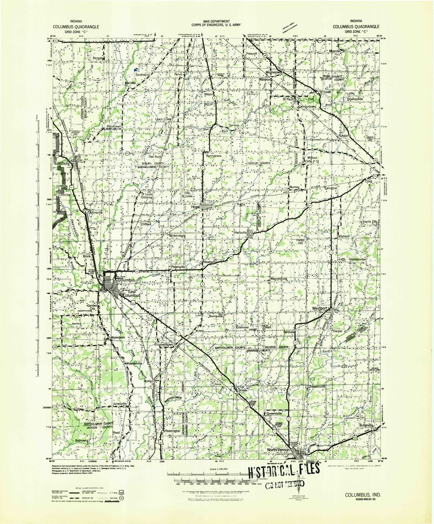
Historic 1942 Columbus Indiana 30'x30' Topo Map
Couldn't load pickup availability
Historical USGS topographic map of Columbus in the state of Indiana. Scale: 1:125000. Print size: 19" x 24"
This map was published in 1942 and is in the following counties: Bartholomew, Decatur, Jackson, Jennings, Johnson, Rush, Shelby.
The map contains contour lines, roads, rivers, towns, streams, and lakes. Printed on high-quality waterproof paper with UV fade-resistant inks.
Contains the following named places: Adams, Alert, Amity Ditch, Amos Ditch, Apple Ditch, Armuth Ditch, Azalia, Bear Creek, Bear Creek, Bengal, Bennetts Branch, Bethel Village, Big Blue River, Big Slough, Bobtown, Brewersville, Brush Creek, Brush Creek, Brush Creek Reservoir, Buck Run, Burney, Burnsville, Butlerville, Camp Clifty, Camp Flat Rock, Catherine Creek, Chambers Ditch, Chicken Creek, Clifford, Clifty Creek, Clifty Creek Park, Cobbs Fork, Columbus, Compton Ditch, Conns Creek, Cooks Creek, Corn Brook, Craig, Cuba, Dailey Lake, Deer Creek, Deer Creek, Denios Creek, Donner Park, Downeyville, Driftwood River, Duck Creek, East Columbus, East Fork Slash Creek, Edinburgh, Elizabethtown, Everroad Park, Ewington, Fall Fork, Fenns, Fish Creek, Fisher Ditch, Flat Rock Park, Flatrock River, Forest Hill, Forest Park, Garden City, Gaynorsville, Geneva, Gibson Ditch, Grammer, Greensburg City Park, Harper, Harris City, Hartsville, Haw Creek, Hope, Horace, Horse Creek, Howell Ditch, Hurricane Creek, Ice Creek, Irwin Park, Jewell Village, Jonesville, Letts, Letts Corner, Lewis Creek, Lick Creek, Lincoln Park, Little Conns Creek, Little Ditch, Little Flatrock River, Little Haw Creek, Little Hurricane Creek, Little Lewis Creek, Little Mutton Creek, Little Sand Creek, Little Tough Creek, Long Branch, Long Lake, Lowell, Major Ditch, Mapleton Corner, Marietta, McCrea Hill, McCue Medsker Ditch, McFarren Ditch, McFarren Hill, Middle Fork Fall Fork, Middle Fork Lake, Middletown, Milford, Mill Creek, Millstone Creek, Money Hill, Moscow, Mount Auburn, Muddy Branch Creek, Muddy Fork Sand Creek, Neff Corner, Nettle Creek, Newbern, Nineveh Creek, Norristown, North Columbus, North Gate, North Park, North Vernon, Northcliff, Old Saint Louis, Opossum Creek, Otter Creek, Parkside, Parrish Ditch, Panther Creek, Peters Lake, Peters Switch, Petersville, Pinhook, Pleasant Run, Pleasant View Village, Pleasure Valley, Pond Branch, Poplar Root Creek, Prescott, Queensville, Reddington, Riverview Acres, Roberts Ditch, Rock Creek, Rock Creek, Rodney Branch, Rosstown, Rugby, Saint Louis Crossing, Saint Omer, Saint Paul, Sand Branch, Sand Creek, Sardinia, Schaefer Lake, Scipio, Selmier State Forest, Shaw Ditch, Shipp Ditch, Sidney Branch, Slash Creek, Slash-Loesch Ditch, Sleepy Hollow, Sloan Branch, Smith Ditch, Smithland, South Fork Lewis Creek, Sugar Creek, Taylorsville, Thompson Ditch, Thompsons Lake, Tough Creek, Trimnell Branch, Turnover Creek, Twin Lakes, Twomile Creek, Van Felt Ditch, Waldron, Walesboro, Waynesburg, Waynesville, Westport, Willow Park, Wilson Corner, Wolf Creek, Wood Lake, Woods Branch, Wrights Hill, Wyaloosing Creek, Rattail Creek, Greenburg Reservoir State Fishing Area, Country Squire Lake, New Albany-Floyd County Park, Schaefer Lake Dam, Germantown, Greersburg City Park Lake Dam, Greersburg City Park Lake, Suhre Lake Dam, Suhre Lake, Lake Barbara, Meyer Lake Dam, Country Squire Lake Dam, Tile Creek, Terrace Lake, Terrace Lake Dam, Schultz Lake, Schultz Lake Dam, Middle Fork Lake Dam, Greenburg Reservoir, Greenburg Reservoir Dam, Morven, Tannersville, Oakdale, West Hill Shopping Center, 25th Street Shopping Center, Eastbrook Plaza, Columbus Shopping Center, Holiday Center Shopping Center, Fishers Fork, John Thompson County Ditch, Flat Rock, Lewis Creek, Nortonburg, Blue Ridge, Decatur County, Buck Branch, Cooley Creek, East Fork White Creek, Bartholomew County, Hansells Station, Crystal Lake, Little Acre, Township of Adams, Township of Blue River


