MyTopo
Historic 1892 Concordia Kansas 30'x30' Topo Map
Couldn't load pickup availability
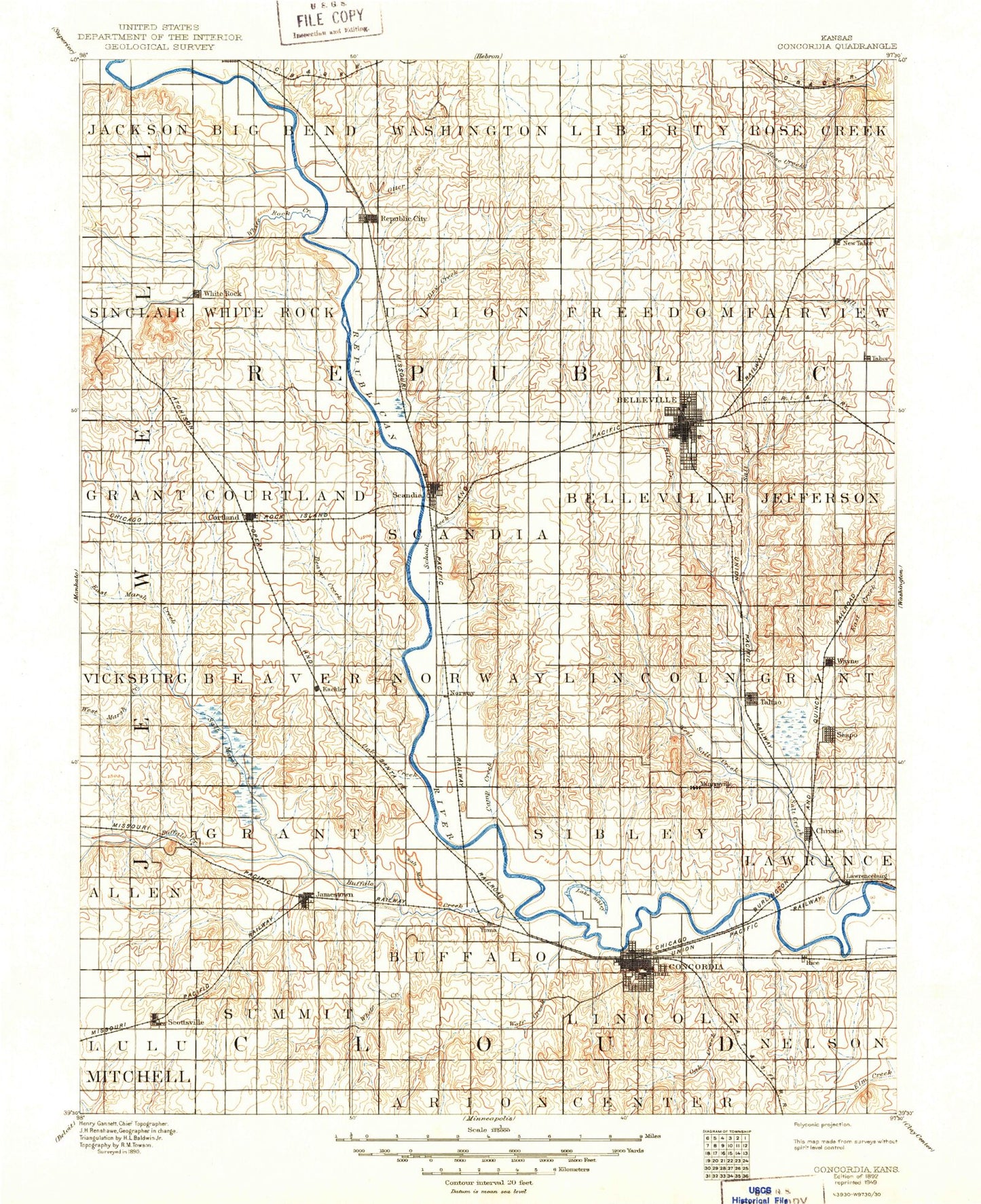
Historical USGS topographic map of Concordiain the states of Kansas, Nebraska. Scale: 1:125000. Print size: 17" x 24"
This map was published in 1892 and is in the following counties: Cloud, Jewell, Mitchell, Republic.
The map contains contour lines, roads, rivers, towns, streams, and lakes. Printed on high-quality waterproof paper with UV fade-resistant inks.
Contains the following named places: Courtland Canal, Township of Jackson, Township of Sinclair, Bean Creek, West Marsh Creek, East Marsh Creek, Township of Grant, Township of Allen, Township of Vicksburg, Little Cheyenne Creek, Township of Lulu, Township of Big Bend, Township of White Rock, Crosby Creek, Forsha Creek, North Canal, Spring Creek, White Rock, White Rock Canal, Miller Canal, White Rock Extension Canal, White Rock Creek, Republic, Otter Creek, Dry Creek, Township of Washington, Harbine, Township of Union, Township of Liberty, Township of Freedom, Township of Rose Creek, Township of Fairview, Munden, Salt Creek, Formoso, Courtland, Courtland West Canal, Lovewell, Beaver Creek, Township of Courtland, Mud Creek, Scandia, School Creek, Belleville, Riley Creek, Township of Jefferson, Coal Creek, East Creek, Jamestown State Waterfront Management Area, Sportsmans Lake, Township of Beaver, Township of Grant, Saint Johns Creek, Skunk Creek, Dry Creek, Marsh Creek, Kackley, Salt Creek, Norway, Oak Creek, Township of Grant, Township of Lawrence, Talmo, Wayne, Little Upton Creek, Turkey Creek, Township of Summit, Whites Creek, Cheyenne Creek, Little Cheyenne Creek, West Branch Wolf Creek, Buffalo Creek, Salt Marsh, Jamestown, Concordia, Second Street Park, Hood Park, Decker Park, Coal Creek, Lost Creek, West Branch Oak Creek, Wolf Creek, Township of Lincoln, Oak Creek, West Branch Elm Creek, East Branch Oak Creek, Township of Nelson, Twin Mounds, Rice, Plum Creek, Pawnee Indian Village, Hollis, Warwick, Sherdahl, Rydal, Tabor, Rosaco, Yuma, Huscher, Cook, Scottsville, Republic County, Belleville Country Club, West Creek, Township of Scandia, Township of Belleville, Township of Norway, Township of Sibley, Township of Buffalo, Grave Creek, Lost Creek, Township of Lincoln, Hay Creek, Cool Creek, City of Belleville, City of Concordia, Crosby Creek, City of Courtland, City of Formoso, City of Munden, City of Jamestown, City of Republic, City of Scandia, City of Scottsville, Belleville Wastewater Treatment Facility, Courtland Wastewater Treatment Facility, Belleville Municipal Power Plant, North Central Kansas Free Fair, Belleville High Banks, Cloud County Fairgrounds, Concordia Waste Treatment Plant, Formoso Wastewater Plant, Jamestown Wastewater Plant, Munden Wastewater Treatment Facility, Republic Wastewater Plant, Scandia Wastewater Treatment Facility, Double J Mobile Home Park, Lewis Mobile Home Park, Concordia American Legion Golf Course, US Highway 81 Weigh Station 58, Agmark Grain Elevator Number 16, Agmark Grain Elevator Number 9, Agmark Grain Elevator Number 1, Agmark Grain Elevator Number 11, Courtland Canal, Crosby Creek, Forsha Creek, Otter Creek, Crosby Creek