MyTopo
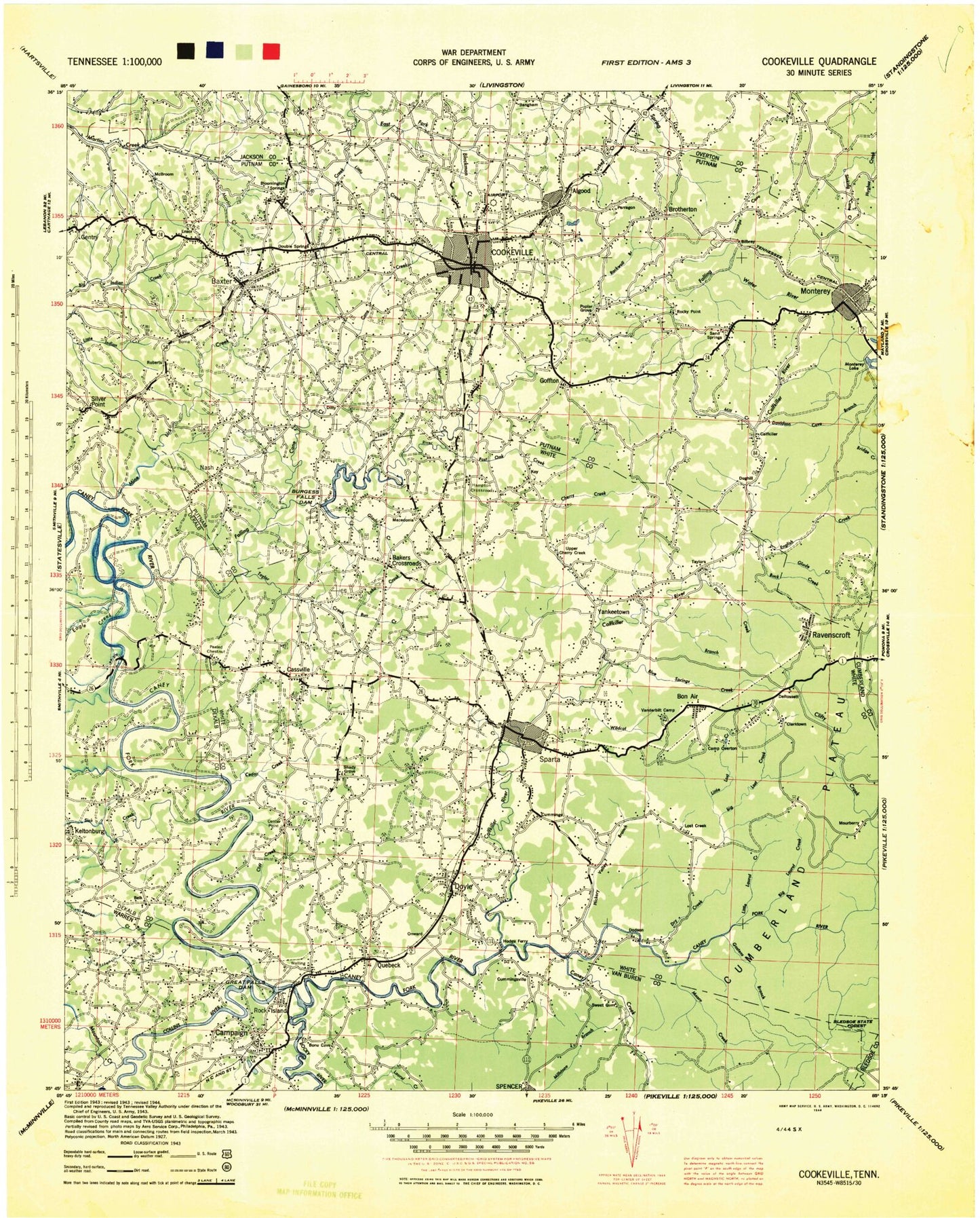
Historic 1944 Cookeville Tennessee 30'x30' Topo Map
Couldn't load pickup availability
Historical USGS topographic map of Cookeville in the state of Tennessee. Scale: 1:100000. Print size: 24" x 27"
This map was published in 1944 and is in the following counties: -.
The map contains contour lines, roads, rivers, towns, streams, and lakes. Printed on high-quality waterproof paper with UV fade-resistant inks.
Contains the following named places: Dog Cove, Geer Cove, Sparta, Town Creek, Twin Branch, Baker Mountain, Bear Cove, Big Laurel Creek, Blue Spring Cove, Blue Spring Creek, Brandy Hollow, Buck Creek, Buck Creek Lake, Buzzard Mountain, Camp Belle Aire, Camp Shuerman, Cherry Creek, Chestnut Mountain, De Rossett, Doe Creek, Doe Creek Lake, Findlay, Glade Creek, Goulden Mountain, Hasting Cove, Hickory Valley Branch, Little Laurel Creek, Little Lost Creek, Lost Creek, Miller Mountain, Millsea Branch, Plum Creek, Pole Bridge Branch, Polly Branch, Ravenscroft, Rockhouse State Memorial, Davis Lake Number Two, Davis Lake Dam Number Two, Billy Branch Lake, Billy Branch Dam, Wheats Curve Lake Dam, Wheats Curve Lake, Spain Lake Dam, Spain Lake, Payne Lake, Payne Lake Dam, Wonder Lake, Wonder Dam, Doe Creek Lake, Doe Creek Lake Dam, Arrowhead Lake, Arrowhead Lake Dam, Key Acres Lake, Key Acres Dam, Rockhouse, Simmons Creek, Hickory Nut Mountain, Monterey Lake, Pine Mountain, Shop Gap, Short Creek, Spring Creek, Stamps Hollow, Stanton Hollow, Stone Cove, Suggs Branch, Table Rock Mountain, Talent Hollow, Tandy Knob, Tayes Hollow, Thompson Ridge, Thorn Gap, Tibbs Hollow, Tom Hollow, Town Creek, Turkey Cot Cove, Turkey Mountain, Verble Hollow, Verble Mountain, Virgin Falls, Walker Hollow, Walker Mountain, Waterfalls Hollow, Welch Hollow, Welch Knob, Whetstone Creek, Whittaker Cove, Willet Mountain, Wilson Ridge, Wiser Hollow, Wright Bend, Yellow Cliff Creek, Zion Branch, Gleason Creek, Alcorn Hollow, Algood Mountain, Barnes Hollow, Barren Creek, Bee Branch, Bee Creek, Bee Rock, Belle Acres Golf Club, Berkshire Gap, Big Bottom, Big Butte, Big Sink, Big Sink, Black Bottom, Black Pond, Blackwell Branch, Blaylock Mountain, Blue Hole, Board Valley, Boiling Pond, Boles Branch, Boma, Boyd Hollow, Bridge Creek, Brotherton, Brown Hollow, Bruce Ridge, Bryant Hollow, Buck Lake, Buck Mountain, Buck Mountain, Buckner Hollow, Burgess Falls, Burgess Falls Lake, Burnett Mountain, Burton Hollow, Camp Clements, Camp Monterey, Camp Overton, Cane Creek, Cane Creek, Cane Hollow, Cane Hollow, Cannon Hollow, Carr Ridge, Carrington Hollow, Cassville, Cave, Cedar Creek, Chimney Springs Hollow, City Lake, Cliff Creek, Collins Branch, Collins River, Cookeville Golf and Country Club, Cope Mountain, County Park Dock, Cummings Cove Branch, Dark Hollow, Dark Hollow Branch, Darkey Spring Branch, Davidson Cove, Double Springs, Doyle, Doyle Hill, Dry Creek, Dry Valley, Duck Pond, East Blackburn Fork, England Cove, Ensor, Flatt Hollow, Flowing Well Branch, Fox Hollow, Gar Island, Gastens Branch, Glade Creek, Goffton, Goulden Mountain, Graveyard Ridge, Great Falls, Great Falls Dam, Great Falls Lake, Green Mountain, Greenbrier Bend, Gross Ridge, Gum Spring Mountain, Gunstock Branch, Haskens Branch, Hell Hole, Hensley Chapel, Hickey, High Knob, Horseshoe Bend, Hudgens Creek, Hunter Cove, Hurd Hollow, Hurricane Creek, Hutchins College, Icy Cove, Irvin Branch, Jake Hollow, Johnson Hollow, Keener Branch, Key, Kitty Ray Mountain, Kuykendall Branch, Lake Creek, Laurel Creek, Lee Knob, Leftwich Hollow, Little Chestnut Mountain, Little Creek, Little Puncheoncamp Branch, Little Sink Branch, Little Top, Long Branch, Long Hollow, Madewell Hollow, Maxwell Branch, Maxwell Lake, McBroom Branch, McCager Point, Milksick Mountain, Mill Creek, Mill Hole, Mill Hollow, Millstone Branch, Mitchell Knob, Monterey, Moore Creek, Moores College, Mountain Creek, Nash, Old Cabin Branch, Onward, Perry Branch, Peter Cave Branch, Phelps Branch, Phifer Mountain, Pilot Knob, Pointer Hollow