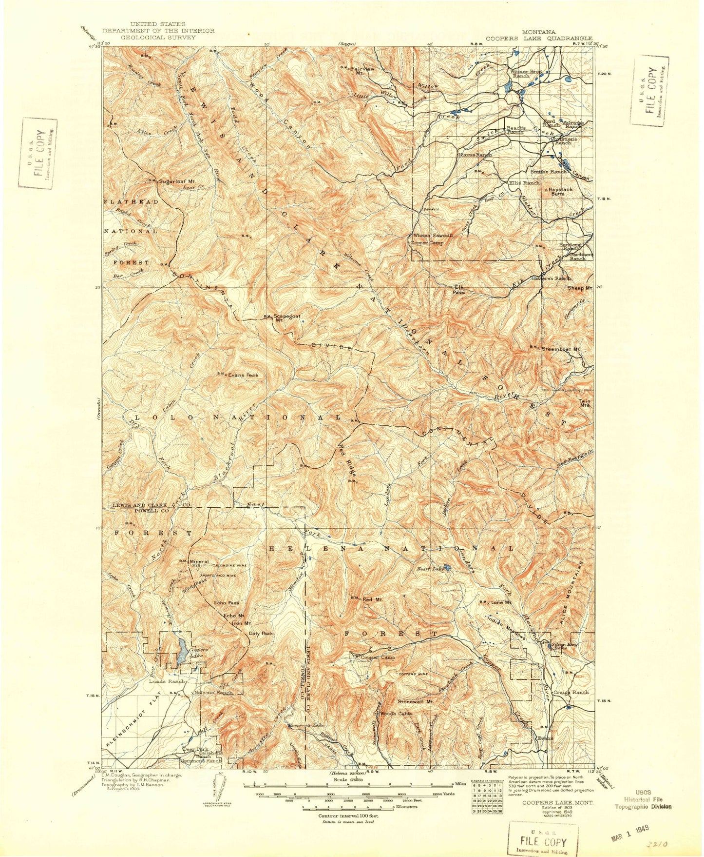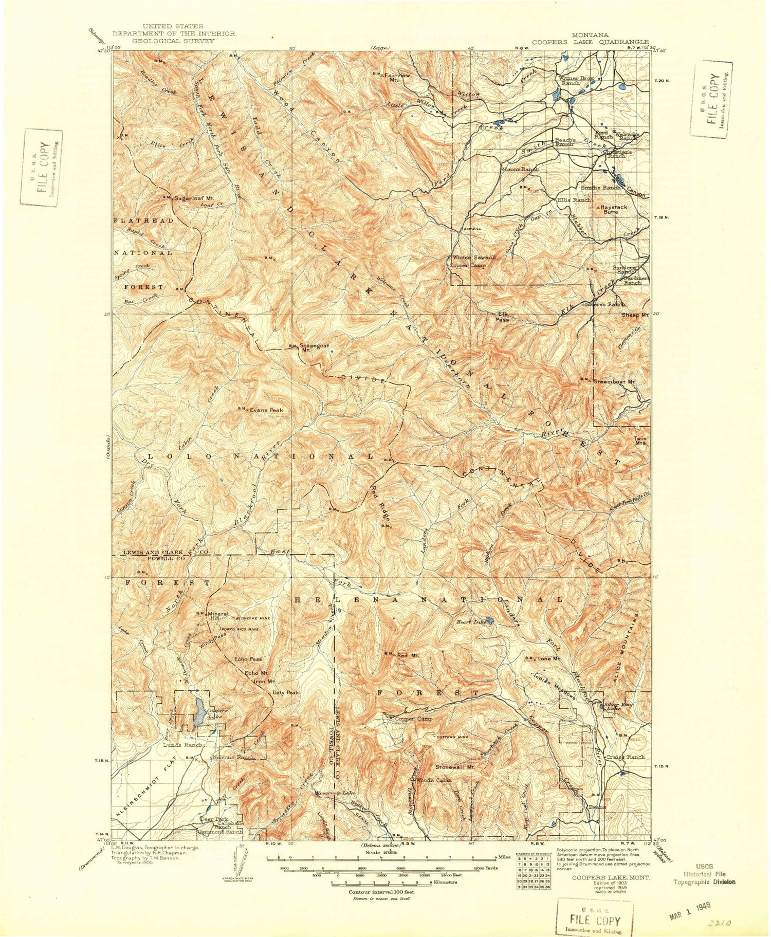
MyTopo
Historic 1903 Coopers Lake Montana 30'x30' Topo Map
Couldn't load pickup availability
Historical USGS topographic map of Coopers Lake in the state of Montana. Scale: 1:125000. Print size: 18" x 24"
This map was published in 1903 and is in the following counties: Lewis and Clark, Powell.
The map contains contour lines, roads, rivers, towns, streams, and lakes. Printed on high-quality waterproof paper with UV fade-resistant inks.
Contains the following named places: Galusha Peak, Alpine Park, Arrastra Mountain, Bear Creek, Bear Lake, Big Nelson Campground, Big Slide, Bugle Mountain, Bull Creek, Callahan Creek, Coopers Lake, Copenhaver Ranch, Daly Peak, Deer Park, Dry Creek, East Fork Mineral Creek, Echo Mountain, Echo Pass, Iron Mountain, Jorgenson Ditch, Kleinschmidt Flat, Lake Mountain, Madison Creek, Madison Meadow, McDermott Creek, McDermott Trail, Meadow Creek Trail, Mineral Creek Trail, Mineral Hill, North Fork Arrastra Creek, Old Lund Ditch, Porcupine Basin, Reservoir Lake, Salmon Creek, Spawn Lake, Spieker Ditch, Tupper Lake, White Tail Ranch, Windy Pass, Scapegoat Wilderness, Benchmark Wilderness Ranch, Wood Lake Campground, Indian Meadows Livestock Trail Head, Sourdough Flats, Webb Lake Guard Station, Day Creek Livestock Trail Head, Reservoir Lake Livestock Trail Head, Patrol Mountain Lookout, Nilan East Dam, Wood Lake Dam, Wood Lake, Nilan North Dam, J B Long and Company Number 2 Dam, J B Long and Company Number 3 Dam, Delta Queen Dam, Anderson Lake Dam, Really Red Dam, Ford Creek Plateau, Wood Canyon, Nilan Reservoir Recreation Site, The Steps, McDonnell Meadow, Packers, Nolo Lake, Upper Copper Lake, Alice Mountains, Alpine Lake, Anderson Lake, Smith Creek Trail, Arrastra Creek Trail, Bailey Basin, Bailey Creek, Baking Powder Creek, Bald Bear Creek, Pear Creek, Bear Den Mountain, Beaver Meadows, Benchmark Campground, Benchmark Creek, Benchmark Work Center, Bighorn Creek, Bighorn Lake, Blackrock Creek, Blacktail Creek, Blacktail Creek Trail, Broadus Creek, Bunch Grass Basin, Bunch Grass Creek, Bunyan Creek, Bunyan Point, Byrnes Creek, C Bar N Camp, Cabin Creek, Cabin Creek Dobrota Trail, Camp Creek, Camp Creek, Canyon Creek, Caribou Peak, Caribou Trail, Carmichael Basin, Carmichael Guard Station, Cataract Basin, Cataract Creek, Cataract Falls, Cave Creek, Cigarette Creek, Cigarette Creek Trail, Cigarette Rock, Cobb Ranch, Cooney Creek, Cooney Creek Trail, Copper Camp, Copper Creek, Copper Creek Campground, Copper Lake, Cotter Creek, Cotter Mine, Crow Creek, Crown Creek, Crown Mountain, Crown Mountain Trail, Cyanide Creek, Cyanide Mountain, Devils Glen, Dobrota Creek, Double Falls, Dry Fork Cabin Creek Trail, Dry Fork North Fork Blackfoot River, Dwight Creek, Eagle Creek, East Fork Blacktail Creek, East Fork Cyanide Creek, East Fork Meadow Creek, East Fork North Fork Blackfoot River, Elbow Creek, Elbow Pass, Elbow Pass Trail, Elk Creek Ranch, Elk Pass, Elk Pass Trail, Ellis Creek, Evans Peak, Fairview Creek, Fairview Mountain, Fairview Plateau, Fairview Trail, Falls Creek, Falls Point, Fickler Creek, Flint Mountain, Fly in Campground, Ford Creek, Ford Willow Creek Trail, Glade Creek, Goss Creek, Grassy Hills, Grassy Hills Cabin, Green Fork Guard Station, Green Fork Straight Creek, Green Timber Creek, Grizzly Basin, Grizzly Creek, Halfmoon Creek, Halfmoon Dearborn River Trail, Halfmoon Park, Halfmoon Peak, Haystack Butte, Heart Lake, Hidden Valley Ranch, Hoadley Creek, Honeymoon Basin, Horse Creek, Horse Mountain, Indian Meadows, Indian Meadows Creek, Indian Meadows Guard Station, Jakey Creek, Jakie Creek, Jakie Creek Trail, Keep Cool Lakes, Klondike Creek, Krohn Lake, L F Ranch, Lake Creek, Lake Fork Bighorn Creek, Landers Fork Trail, Lead Gulch, Lick Creek, Lime Gulch, Little Willow Creek, Liverpool Snowbank Trail, Loaf Creek, Lone Chief Mountain, Lone Mountain, Lone Mountain Trail, Lookout Creek, Lookout Creek, Lost Cabin Cave Creek Trail, Lost Cabin Creek, Lost Pony Creek, Lower Twin Creek, Main Line Trail, Maryann Creek, McCarty Hill, McDonald Meadow, Meadow Creek, Meadow Creek Trail, Meadow Lake, Middle Fork Camp Creek, Middle Fork Creek, Middle Fork Falls Creek, Milky Stream, Mineral Creek, Monitor Mountain, Moudess Creek, Mule Creek, Nilan Reservoir, No Grass Creek, North Fork Copper Creek, North Fork Falls, North Fork Ford Creek, North Fork Guard Station, North Fork Trail, Observation Pass, Observation Point, Olson Peak, Park Creek, Parker Lake, Pass Creek, Patrol Mountain, Patrol Mountain Lookout Trail, Petty Creek, Petty Crown Creek Trail, Petty Ford Creek Trail, Pyramid Peak, Red Creek