MyTopo
Historic 1896 Coos Bay Oregon 30'x30' Topo Map
Couldn't load pickup availability
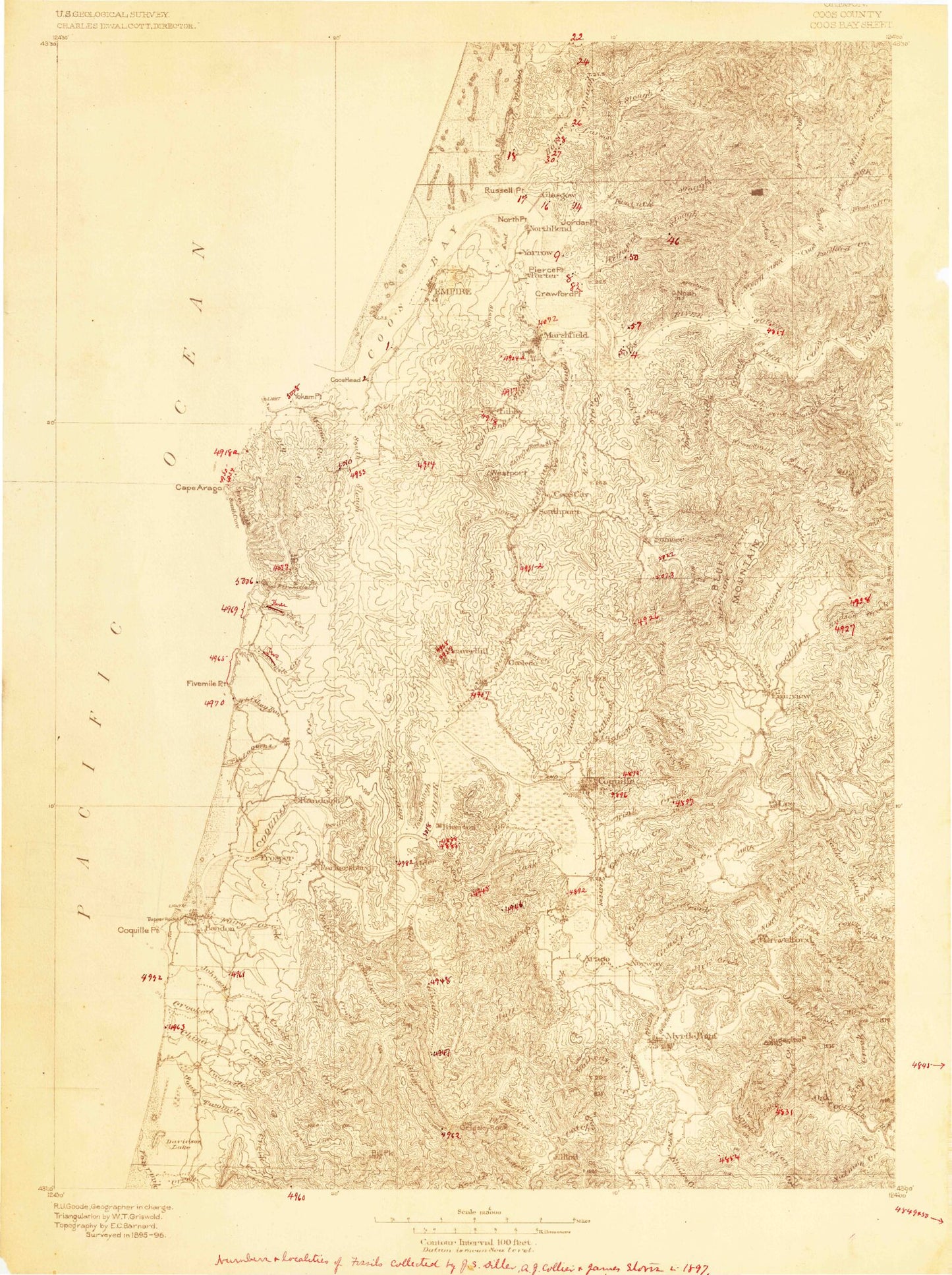
Historical USGS topographic map of Coos Bay in the state of Oregon. Scale: 1:125000. Print size: 15" x 24"
This map was published in 1896 and is in the following counties: Coos.
The map contains contour lines, roads, rivers, towns, streams, and lakes. Printed on high-quality waterproof paper with UV fade-resistant inks.
Contains the following named places: Palouse Slough, Agate Beach, Alder Creek, Allegany, Anderson Mountain, Arago, Baldy Butte, Baltimore Rock, Bandon, Bandon Reservoir, Bandon State Park, Bear Creek, Beaver Creek, Beaver Hill, Beaver Hill, Beaver Slough, Bennett County Park, Bessey Creek, Big Creek, Big Creek, Big Devil Gulch, Bill Creek, Bill Peak, Blair Creek, Blake Gulch, Blossom Gulch, Blue Ridge, Boone Creek, Boys Forest Ranch, Bradley Lake, Bridge, Broadbent, Budd Creek, Budd Mountain, Bullards Beach State Park, Burton Prairie, Buzzard Rock, Calloway Creek, Camp Tawanka, Cape Arago State Park, Cardwell Creek, Carey Creek, Caroline Bar Creek, Cat and Kittens Rock, Catching Creek, Catching Creek, Catching Slough, Cave Creek, Cherry Creek, Chicken Gulch, China Creek, China Creek, Chrome, Chrome Lake, Coak Creek, Coal Creek, Coalbank Slough, Coaledo, Coffee Creek, Cold Creek, Collver Point, Coos County Forest, Coquille, Coquille Rock, Coquille Valley, Cove Creek, Cox Canyon, Crooked Creek, Crown Point, Daggett Creek, Daniels Creek, Davis Creek, Davis Slough, Dellwood, Deton Creek, Devils Elbow, Devils Kitchen, Dew Valley, Dew Valley, Dutch John Ravine, Dye Creek, East Fork Coquille River, East Fork Millicoma River, Eastside, Echo Valley, Elk Creek, Endicott Creek, Evans Creek, Face Rock, Fahys Creek, Fahys Lake, Fairview, Fall Creek, Fat Elk Creek, Ferry Creek, Ferry Creek, Ferry Creek Reservoir, Fishtrap Creek, Five Foot Rock, Fortier Field, Fossil Point, Four Bit Gulch, Fourmile, Fourth Creek, Fourth Creek Reservoir, Garage Creek, Geiger Creek, Geiger Creek Reservoir, Gettys Creek, Giles Creek, Glen Aiken Creek, Goat Creek, Grady Creek, Gravelford, Graveyard Point, Gray Creek, Grigsby Rock, Gross Creek, Hall Creek, Hatchet Slough, Haystack Rock, Hayward Creek, Hendrickson Creek, Henrys Falls, Hervey Quarry, Hoffman Memorial State Park, Horse Hollow, Hudson Creek, Hungry Hollow, Hungry Mountain, Isthmus Slough, Jerusalem Creek, John B Creek, Johns Creek, Judah Parker County Park, Kessler Creek, King Creek, Knight Creek, Kuhnert Quarry, Lampa Creek, Laurel Grove, Laurel Lake, LaVerne County Park, Laverne Falls, Lawhorne Creek, Laxstrom Gulch, Lee Valley, Libby Arm, Libby Mine, Lillian Creek, Little Bear Creek, Little Fishtrap Creek, Llewellyn Creek, Lost Creek, Lowe Creek, Lower Twomile Creek, Mack Creek, Manning Gulch, Marlow Creek, Marsters Rock, Mart Davis Creek, Mast Creek, Matheny Creek, Matson Creek, McKeever Mountain, McKinley, McMullen Creek, Middle Creek, Middle Creek County Park, Mill Creek, Millicoma River, Miner Creek, Monkey Ranch Gulch, Monroe Creek, Montgomerys Cabin, Moon Creek, Morgan Creek, Mussel Creek, Myers Creek, Myrtle Point, Neely Creek, Noble Creek, Noble Hill, North Fork Coquille River, Norton Gulch, Nowlin Creek, Offield Creek, Overland Mine, Packard Creek, Panther Creek, Peterson Gulch, Pidgeon Falls, Piledriver Creek, Pleasant Hill School, Pleasant Valley, Pogue Gulch, Pulaski Creek, Rainy Creek, Randleman Creek, Randolph Island, Randolph Slough, Redibaugh Creek, Rich Creek, Rink Creek, Rink Creek Reservoir, Rink Peak, Robbins Butte, Rock Prairie County Park, Rock Robinson Creek, Rocky Point, Rogers Creek, Rollan Creek, Rooke and Higgins County Park Boat Ramp, Ross Slough, Round Lake, Sacchi Beach, Sanford Heights Playground, Schneider Butte, Schoolhouse Creek, Sea Lion View Point, Seelander Creek, Seven Devils State Park, Sevenmile Creek, Shell Island, Shinglehouse Slough, Shore Acres State Park, Shuck Mountain, Simpson Creek, Simpson Reef, Smith Creek, Snedden Creek, South Fork Coos River, South Twomile Creek, Southport Mine, Spring Creek, Spring Creek