MyTopo
Historic 1898 Cottonwood Falls Kansas 30'x30' Topo Map
Couldn't load pickup availability
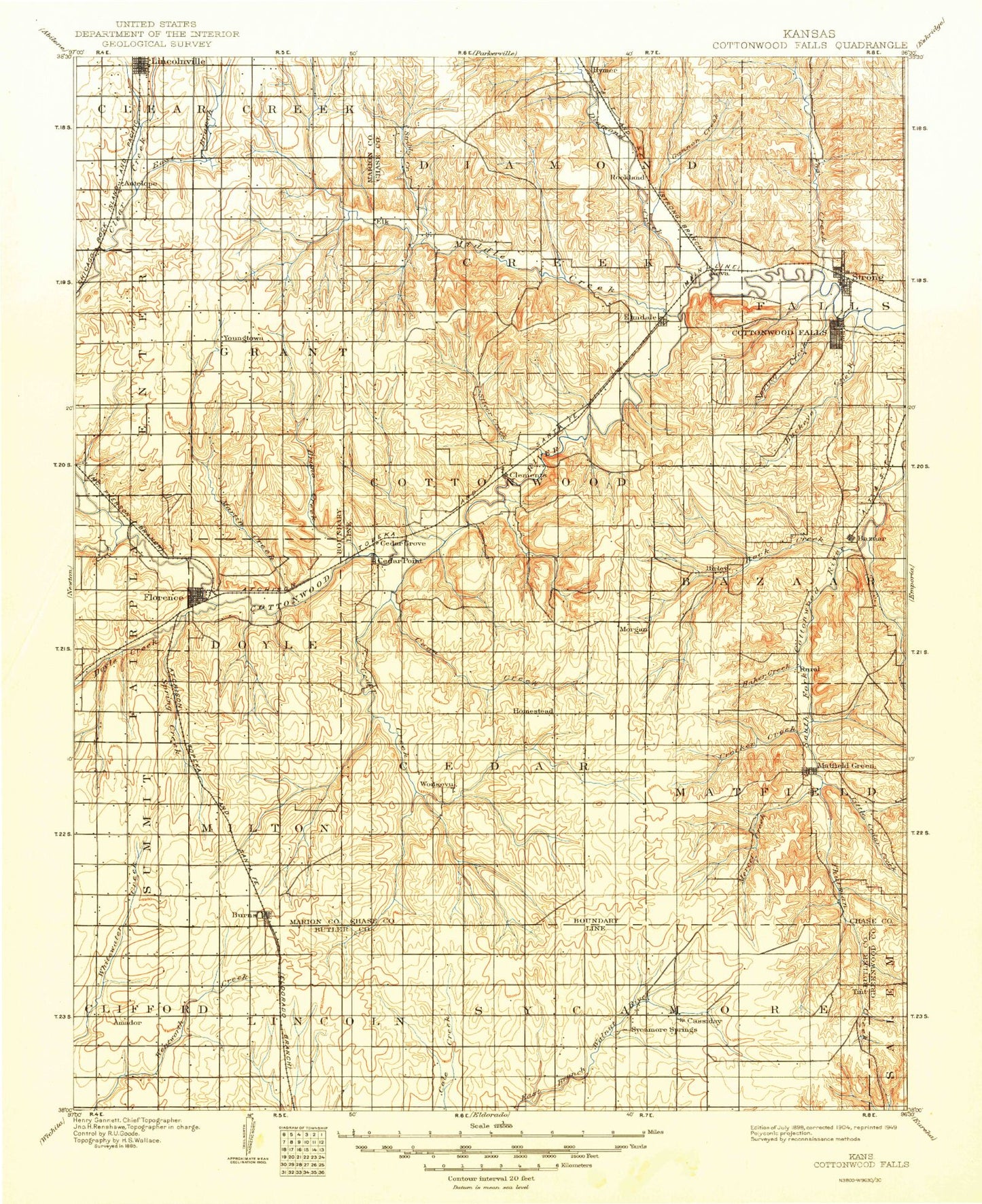
Historical USGS topographic map of Cottonwood Falls in the state of Kansas. Scale: 1:125000. Print size: 17" x 24"
This map was published in 1898 and is in the following counties: Butler, Chase, Greenwood, Marion.
The map contains contour lines, roads, rivers, towns, streams, and lakes. Printed on high-quality waterproof paper with UV fade-resistant inks.
Contains the following named places: Township of Clifford, Township of Sycamore, Diamond Creek, East Branch Clear Creek, Township of Clear Creek, Middle Creek, Schaffer Creek, Township of Diamond Creek, Palmer Creek, Fox Creek, Township of Strong, Township of Centre, Antelope, Lost Creek Oil and Gas Field, Lincolnville, Wildcat Creek, Stribby Creek, Township of Grant, Elmdale, Collett Creek, Mulvane Creek, Prather Creek, Spring Creek, Cottonwood Falls, Strong City, Gannon Creek, Township of Falls, Township of Fairplay, Florence, Catlin Creek, Martin Creek, Marion County Park, Marion County Lake, Township of Doyle, Bruno Creek, French Creek, Cedar Point, Township of Cottonwood, Coyne Branch, Clements, Silver Creek, Holmes Creek, Gould Creek, Camp Wood, Bazaar, Den Creek, Rock Creek, Yeager Creek, Folsom Creek, Sharpes Creek, Buck Creek, Chase County State Lake, Swope Park, Township of Bazaar, Township of Summit, Spring Creek, Doyle Creek, Grandview Park, Township of Milton, Middle Creek, Bills Creek, Wonsevu, Turkey Creek, Township of Homestead, Township of Cedar, Brush Creek, Cedar Creek, Homestead, Coon Creek, Little Cedar Creek, Matfield Green, Jack Creek, Mercer Creek, Crocker Creek, Corn Creek, Steak Bake Creek, Rural, Kirk Creek, Nickel Creek, Knute Rockne Memorial Monument, Baker Creek, Shaw Creek, East Branch Sharpes Creek, Burns, School Branch, Cassoday, Fox Lake, Matfield Green Service Facility, Thurman Creek, Chase State Fishing Lake and Wildlife Area, Chase County State Lake Dam, Marion County Dam, Flint Hills Rodeo Grounds, Davis Gas Field, Moses Shane Memorial Park, Rockland, Hymer, Neva, Oursler, Chase County, Cedar Point Lake, City of Florence, Tallgrass Prairie National Preserve, City of Burns, City of Cottonwood Falls, City of Cassoday, City of Cedar Point, City of Elmdale, City of Matfield Green, City of Lincolnville, City of Strong City, Cottonwood Falls Wastewater Treatment Facility, Strong City Wastewater Treatment Plant, Burns Wastewater Plant, Cassoday Wastewater Plant, Elmdale Wastewater Plant, Florence Wastewater Plant, Lincolnville Wastewater Plant, Agricultural Producers Grain Elevator Number 6, Team Marketing Alliance Grain Elevator Number 6, Team Marketing Alliance Grain Elevator Number 13, Flying W Ranch