MyTopo
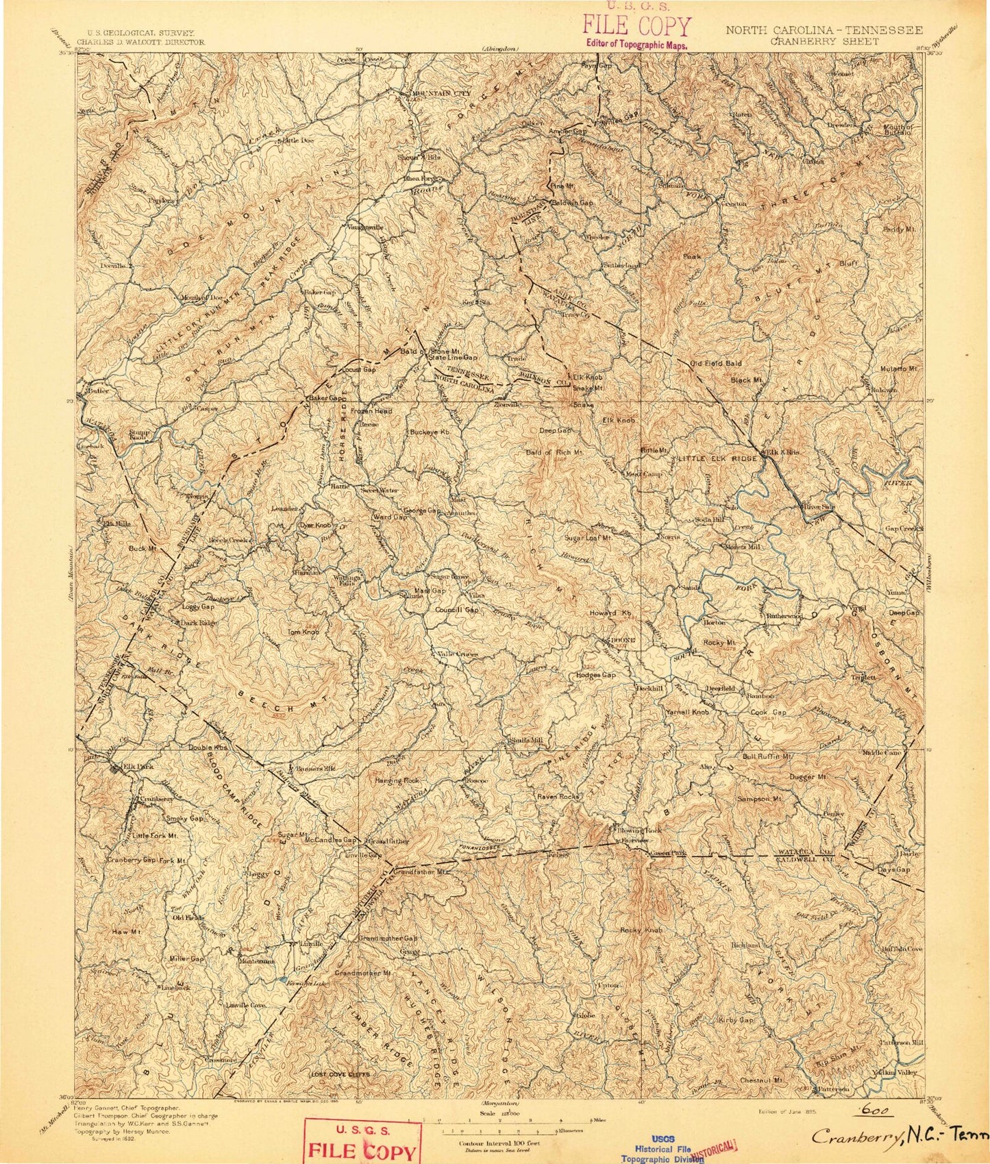
Historic 1895 Cranberry North Carolina 30'x30' Topo Map
Couldn't load pickup availability
Historical USGS topographic map of Cranberry in the state of North Carolina. Scale: 1:125000. Print size: 17" x 24"
This map was published in 1895 and is in the following counties: Ashe, Avery, Burke, Caldwell, Carter, Johnson, Sullivan, Watauga, Wilkes.
The map contains contour lines, roads, rivers, towns, streams, and lakes. Printed on high-quality waterproof paper with UV fade-resistant inks.
Contains the following named places: Anthony Creek, Ashley Branch, Baird Creek, Bald Mountain, Baldwin, Baldwin Gap, Banjo Branch, Bearpen Branch, Bee Branch, Bee Branch, Bee Ridge, Ben Bolen Creek, Bens Ridge, Big Branch, Big Branch, Big Branch, Big Ridge, Bill White Creek, Black Mountain, Blood Camp Branch, Blood Camp Ridge, Bluff Mountain, Boone Camp Branch, Bowers Gap, Broadstone Lodge, Brown Branch, Brownwood, Brush Fork, Buck Ridge, Buffalo Creek, Cabbage Creek, Call Creek, Camp Branch, Carroll Branch, Carroll Gap, Chestnut Branch, Chetola Lake, Clark Creek, Claybank Creek, Clear Branch, Cook Branch, Cook Gap, Copeland Creek, Couches Creek, Council Gap, Cove Creek Ridge, Cranberry Creek, Curly Mapel Ridge, Dark Hollow, Days Creek, Days Gap, Deadman Gap, Deep Gap, Deep Gap, Doe Branch, Dry Pond Gap, Dutch Creek, East Ridge, Elk Creek, Elk Horn Gap, Elk Ridge, Elk Ridge, Elk Ridge, Fig, Flat Branch, Fleetwood, Four Diamond Ridge, Goshen Branch, Grandview Overlook, Grapevine Gap, Grassy Creek, Grassy Island, Graybeal Branch, Gwyn Ridge, Hanging Rock Creek, Hanging Rock Gap, Hanging Rock Ridge, Hayes Bluff, Hillside Branch, Horse Bottom Creek, Horse Bottom Ridge, Horton Branch, Horton Gap, Hoskin Fork, Jones Branch, Jones Branch, Laurel Branch, Laurel Creek, Laurel Knob Gap, Laurel Knob Mountain, Laurence Knob, Laxon, Laxon Creek, Left Fork Mulberry Creek, Little Buffalo Creek, Little Creek, Little Dugger Mountain, Little Elk Creek, Little Elk Ridge, Little Gap Creek, Little Laurel Creek, Locust Ridge, Loggy Ridge, Long Cove, Long Hope Creek, Long Hope Falls, Long Ridge, Lost Branch, Lou Hollow, Maine Branch, Martin Gap, Mast Gap, Mast Knob, Meadow Creek, Meat Camp Creek, Mill Creek, Mill Creek, Mill Pond, Mill Ridge, Mine Branch, Monkey Branch, Moody Mill Creek, Simone Mountain, Norris Fork, North Fork Laurel Creek, Old Field Bald, Old Fields Creek, Oliver Hollow, Osborne Mountain Overlook, Paddy Mountain, Pasley Cove, Pasleys Ridge, Peak Cove, Peak Valley, Pierce Ridge, Pigeonroost Creek, Pine Branch, Pine Knob, Pine Knob Branch, Pine Mountain Branch, Pine Orchard Creek, Pine Ridge, Pine Run, Ponds of the Beech, Poor Knob, Pottertown Gap, Pounding Mill Branch, Price Lake, Puncheon Cove, Queen Ridge, Raccoon Branch, Rich Mountain, Rocky Knob, Rocky Knob, Rocky Knob, Rominger, Roundabout Creek, Rush Branch, Rutherwood, Salt Rock Gap, Sandpit Branch, Sawmill Branch, Shawneehaw Creek, Simmons Ridge, Smethport, Snakeden Mountain, Snakeden Ridge, Snyder Branch, Snyder Gap, Soup Bean Branch, South Branch North Fork New River, South Fork Laurel Creek, Spice Bottom Creek, Spice Branch, State Line Gap, Stone Mountain, Stony Fork Valley Overlook, Storey Branch, Sugar Tree Branch, Sugarloaf Gap, Sugartree Ridge, Swift Ford Branch, Tar Ridge, Thaxon Creek, Three Top Creek, Tonys Branch, Townsend Gap, Trout Creek, Trout Lake, Turkeypen Branch, Valley Creek, Wallace Branch, Watson Gap, White Rock Ridge, Willen Gap, Wilson Branch, Wolf Ridge, Wolfden Branch, Worley Creek, Young Hollow, Land Harbors Lake Dam, Ash Bear Pen Dam, Devils Lake Dam, Trout Lake Dam, Trout Lake, Bright Penny Lake Dam, Bright Penny Lake, Rosasco Dam Upper, Rosasco Lake Upper, Different Drum Lake, Different Drum Dam, Fleetwood Falls Dam, Fleetwood Falls Lake, Cobb Creek, Payne Gap, Rich Mountain Bald, Rich Mountain Gap, Rittle Fork, Rock Creek, Mast Farm Inn, Mast General Store, Mill Ridge, Powderhorn Mountain, Ski Mountain, Solo, Sutherland, Mountain Aire Golf Club, Hemlock Ridge, Ashe County, Avery County, Watauga County, Addies Branch, Aho Branch, Amos Creek, Andrews Creek, Anthony Bolick Branch