MyTopo
Historic 1906 Crawfordville Georgia 30'x30' Topo Map
Couldn't load pickup availability
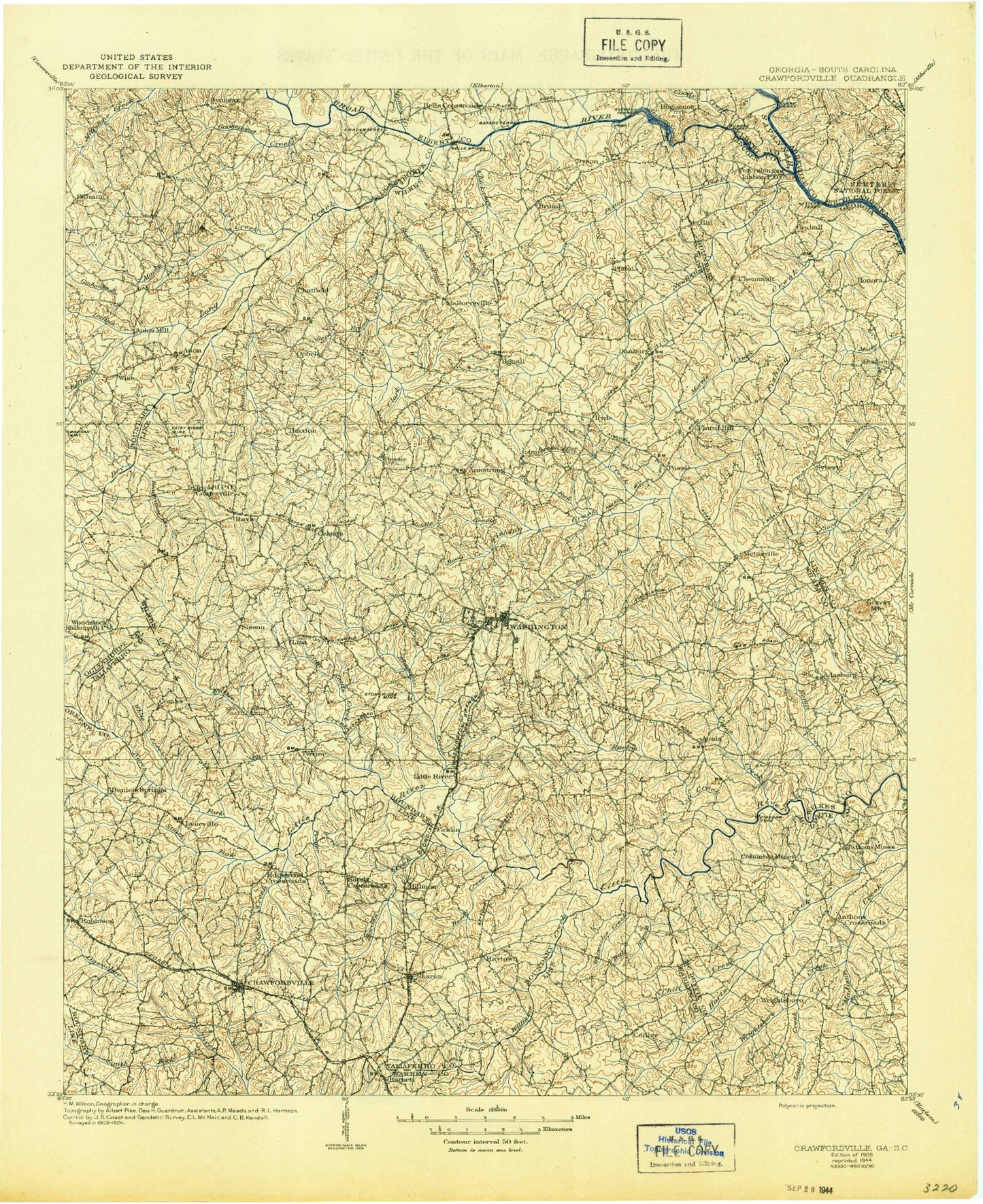
Historical USGS topographic map of Crawfordville in the state of Georgia. Scale: 1:125000. Print size: 18" x 24"
This map was published in 1906 and is in the following counties: Elbert, Greene, Lincoln, McCormick, McDuffie, Oglethorpe, Taliaferro, Warren, Wilkes.
The map contains contour lines, roads, rivers, towns, streams, and lakes. Printed on high-quality waterproof paper with UV fade-resistant inks.
Contains the following named places: Anderson Mill Creek, Andrew Branch, Anthony Shoals, Armstrong Branch, Beaverdam Creek, Beaverdam Creek, Beaverdam Creek, Beaverdam Creek, Beck Branch, Benson Branch, Brickhouse Branch, Broom Creek, Buffalo Creek, Carlton Branch, Cedar Creek, Centerville Branch, Channel Branch, Chapel Branch, Chickasaw Creek, Childers Creek, Clark Creek, Cow Mire Branch, Crawfordville, Dry Fork Creek, Ellington Branch, Fountain Campground, Gold Mine Branch, Goosepond Creek, Goshen Branch, Greensboro Branch, Gualett Branch, Gunn Hill Branch, Harden Creek, Hatchet Branch, Hobb Branch, Hog Fork, Holliday Park, Hood Branch, Hubert Branch, Hutton Creek, Indian Creek, Jacksons Store, Jerry Branch, Jocko Creek, Johnson Pond, Jordan Branch, Kary Wood Branch, Kemp Creek, Kettle Creek, Killico Branch, King Branch, Lick Creek, Linesville Branch, Little Beaverdam Creek, Little Creek, Little Kettle Creek, Little Macks Creek, Lunceford Branch, Macks Creek, Magruda Mines, Mallorysville, Middle Creek, Middle Creek, Mile Branch, Mill Branch, Mine Branch, Moore Branch, Morgan Branch, Morris Creek, Nancy Hart State Park, North Prong Williams Creek, Pole Branch, Porters Branch, Powder Creek, Rains Branch, Reedy Branch, Reedy Creek, Rehoboth Branch, Rock Creek, Rocky Creek, Sandy Cross, Sardis Branch, Sardis Branch, Sharon, Sherrills Creek, Sims Ditch, Soapstone Branch, South Fork Little River, South Fork Ogeechee River, Steep Hill Branch, Stephens Creek, Susan Smith Branch, Tanyard Branch, Tanyard Branch, Threemile Creek, Tuggle Branch, Upton Creek, Ware Branch, White Creek, Whitesides Creek, Williams Creek, Williamson Branch, Wolf Branch, Wynn Creek, Adasburg, Aonia, Beulah, Broad, Celeste, Edgewood Crossroads, Jacksons Crossroads, Linesville, Lovelace, Lundberg, Lyneville, Metasville, Norman, Raytown, Robinson, Sandtown, Saxon, Springfield, Sybert, Veribest, Vesta, Beach Branch, Chennault, Fishing Creek, Graball, Honora, Long Creek, Midway, Newford Creek, North Fork Little River, Pistol Creek, Cadley, Cedar Rock, Cohentown, Curry Hill, Enterprise, Ficklin, Goshen, Graves Mountain, Gunn Hill, Hillman, Little River, Logan, New Town, Oak Grove, Palmetto, Philomath, Prather, Rayle, Sandy Hill, Tyrone, War Hill, Gill, Lisbon, Fairview, Morgan Mine, Philomath Historic District, Ray Dam, Ray Lake, Mcbrayer Lake Dam, Mcbrayer Lake, Norman Lake Dam, Norman Lake, Alexander Stephens Park Lake Dam, Alexander Stephens Park Lake, University of Georgia Farm Lake Dam, University of Georgia Farm Lake, Alezander Stephens State Park Dam, Harris-Burdette Dam Two, Harris-Burdette Lake Two, Burdette-Harris Dam Number One, Burdette-Harris Lake Number One, Washinton-Wilkes Orchard Dam, Washington-Wilkes Orchard Lake, Garrard Dam, Garrard Lake, Hale Lake Dam, Hale Lake, Grimaude Lake Dam, Grimaude Lake, Booth Lake Dam, Booth Lake, Shillinglaw Lake Dam, Shillinglaw Lake, Washington Country Club Lake Dam, Washington Country Club Lake, Palmer Lake Dam, Palmer Lake, City of Washington Reservoir Dam, City of Washington Reservoir, Beaverdam Creek Dam, Beaverdam Creek Lake, Edwards Lake Dam, Edwards Lake, Knox Lake Dam, Knox Lake, Francis Lake Dam, Francis Lake, Anne Heights, Bi-Lo Plaza Shopping Center, Brickhouse, Callaway, Daniel, Fairy Ridge Mine, Fish Dam Bend, Fishing Creek Public Hunting Area, Green Island, Jackson Heights, Lincoln Heights, Porters, Ranger Stadium, Ravenwood Park, Stony Ridge Mine, Tiger Stadium, War Hill Monument, Washington Heights, Belle Meade Country Club, Washington Country Club, North Fork Ogeechee River, Taliaferro County, Thigpen, Bobby Brown State Park, Anthony Crossroads, Busseys Bend, Griffins Bend, Shaws Bend, Storks Bend, Three Points, Todds Branch, Lynn Creek, Wilkes County, Kendrick Creek