MyTopo
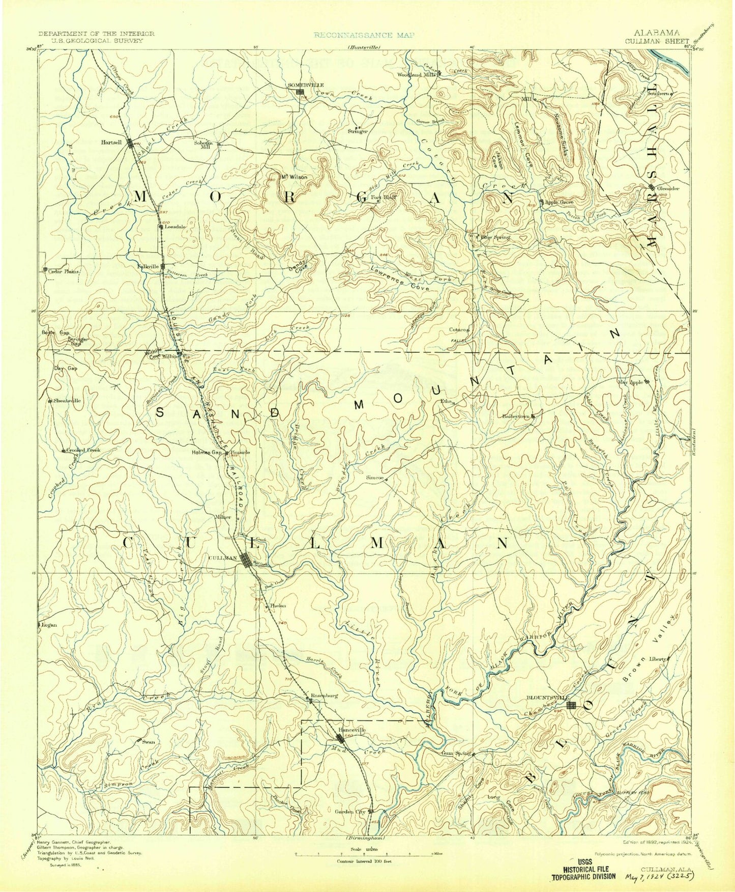
Historic 1892 Cullman Alabama 30'x30' Topo Map
Couldn't load pickup availability
Historical USGS topographic map of Cullman in the state of Alabama. Scale: 1:125000. Print size: 17" x 24"
This map was published in 1892 and is in the following counties: Blount, Cullman, Madison, Marshall, Morgan.
The map contains contour lines, roads, rivers, towns, streams, and lakes. Printed on high-quality waterproof paper with UV fade-resistant inks.
Contains the following named places: Beckworth Branch, Copeland Creek, Copeland Creek, Adams Branch, Aiken Mountain, Albritton Creek, Alvis Branch, Andy Branch Hollow, Austin Creek, Bailey Mountain, Baileyton, Baileytown, Baldwin, Ballew Point, Barnes Hollow, Bates Hollow, Bavar Creek, Bean Mountain, Bear Branch, Bear Hollow, Bee Bluff, Benton Round Mountain, Berry Creek, Berry Mountain, Bethel, Billy Ridge, Birdsong, Blacken Branch, Blackwood Bend, Blountsville, Blountsville Valley, Blue Hole Picnic Area, Blue Ridge, Blue Springs, Blue Springs Creek, Bone Creek, Boston Hollow, Bowling Branch, Bridge Creek, Brindley Creek, Brindley Hollow, Broglen River, Brooklyn, Brushy Creek, Buck Branch, Buckeye Hollow, Bullard Branch, Bunker Branch, Burgess Spring Lakes, Burney Mountain, Buttermilk Mountain, Buzzard Branch, Cabin Creek, Cagle Hollow, Camp Cullman, Camps Lake, Cane Creek, Carver Point, Catalina Point, Cave Hollow, Cedar Cove, Cedar Creek, Cedar Mountain, Cedar Mountain, Cedar Ridge, Center Community, Center Dale, Center Grove Mountain, Center Hill, Centerville, Chaney Branch, Cherry Hollow, Childs Hollow, Clarksville Mountain, Clear Creek, Cook Gap Mountain, Coon Hollow, Cooper Mountain, Cooper Mountain, Copeland Cove, Copper Spring Hollow, Copperas Branch, Copperas Branch, Coppers Branch, Cosby Hollow, County Line, Cranford Branch, Crawford Chute, Crawford Point, Cullman, Derrick Hollow, Devils Cellar Hollow, Dogwood Point, Doss Mountain, Dry Branch, Dry Creek, Dry Creek, Duck Creek, Duck River, Dyers Crossroads, East Fork Flint Creek, East Point, Eddy, Edmundson Hollow, Eightmile Creek, England Creek, Eva, Fairview, Fairview Mountain, Falkville, Fall Creek, Five Points, Flat Rock Branch, Flat Top, Florette, Ford Branch, Fort Bluff, Fowler Cove, Fowler Mountain, Fowler Spring, Frost Creek, Gandy Cove, Gandy Cove, Garden City, Garden City Mountain, Gay Branch, Georgia, Georgia Bend, Georgia Mountain, Gill Creek, Gilliam Creek, Gin Branch, Glasscock Creek, Goat Hollow, Goat Island, Gold Ridge, Good Hope, Goodson Branch, Graves Creek, Greasy Cove, Greenbriar Cove, Gullion Mountain, Gum Pond, Gum Spring Creek, Gum Springs, Gurley Mountain, Guyer Branch, Guyer Cove, Hale Mountain, Hamilton Mountain, Hanceville, Hart Lake, Haynes Mountain, Henderson Branch, Henderson Creek, Herring Branch, Hog Branch, Hog Jaw, Hog Jaw Creek, Hog Mountain, Holmes Gap, Huckleberry Branch, Hughes Creek, Hulaco, Hunter Branch, Hurricane Creek, Hurricane Creek, Indian Creek, Indian Creek, Ivy Hollow, Jackson Cove, Jaybird Creek, Joe Hollow, Johnson Hollow, Joiner Branch, Jones Branch, Joppa, Joppa Creek, Jordan Branch, Joy, Kennedy Creek, Key Hollow, Kid Creek, Killpatrick Creek, Kimbrell Branch, King Branch, King Hollow, Kinney Mountain, Lacon Mountain, Lawrence Cove, Leesdale, Lick Creek, Lick Creek, Light Gap, Little Rock Creek, Long Branch, Longview, Lovers Leap, Lyle Branch, Lynn Creek, Lynntown, Mack Creek, Mack Ralph Mountain, Maple Branch, Mardis Branch, Martin Hollow, McAllister Mountain, McAnear Creek, Mead Hollow, Meadowood, Merritt Bottom, Middle Ridge, Mill Bluff, Mill Hollow, Millie Branch, Milligan Cove, Minnow Creek, Moats Hollow, Moody Branch, Moon Hollow, Moore Branch, Moore Mountain, Morgan City, Morrow Hollow, Morrow Mountain, Moss Spring Branch, Mount View, Mountain Grove, Mountain Grove Branch, Mud Creek, Mud Creek, Mud Creek, Murphree Lake, Murphy Mountain, Narrow Ridge, Nebrigs Hill