
MyTopo
Historic 1906 Dadeville Alabama 30'x30' Topo Map
Couldn't load pickup availability
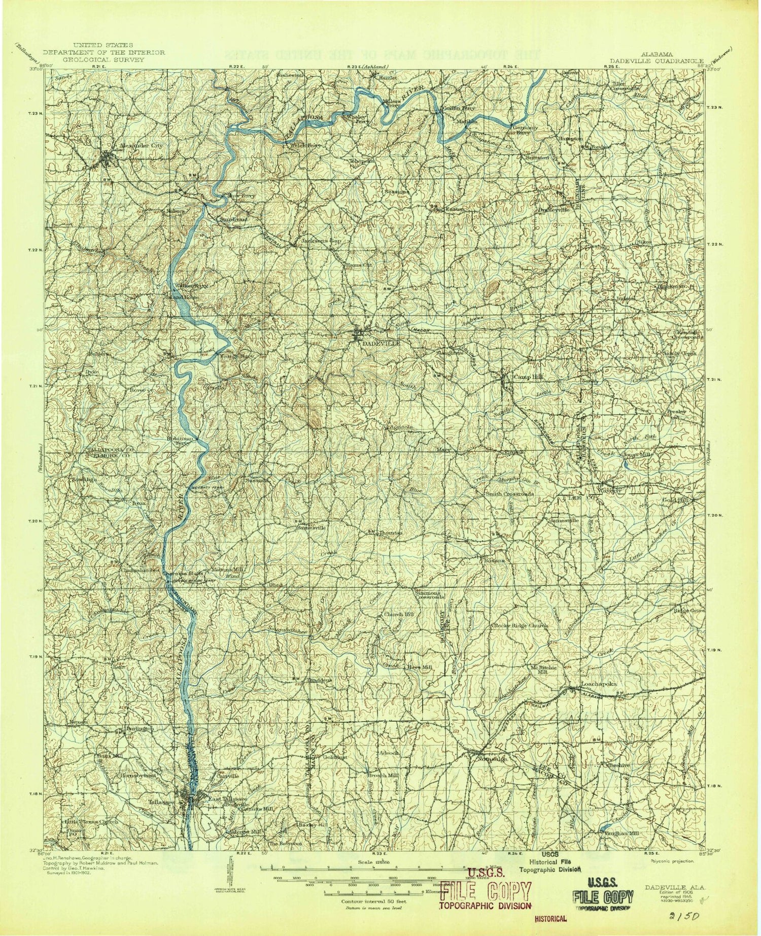
Historical USGS topographic map of Dadeville in the state of Alabama. Scale: 1:125000. Print size: 18" x 24"
This map was published in 1906 and is in the following counties: Chambers, Coosa, Elmore, Lee, Macon, Tallapoosa.
The map contains contour lines, roads, rivers, towns, streams, and lakes. Printed on high-quality waterproof paper with UV fade-resistant inks.
Contains the following named places: Alexander City, Allen Creek, Andrews Branch, Baxley Hill, Bird Creek, Blackman Creek, Blue Creek, Buck Creek, Buck Creek, Buckville, Camp Hill, Cane Creek, Carrville, Cherokee Bluffs, Coley Creek, Copper Creek, Dadeville, Doss Mountain, Double Bridges Park, Dudleyville, Eagle Creek, Emfinger Branch, Fosheeton, Fox Creek, Friendship, Gin Branch, Gin House Branch, Gold Branch, Gold Hill, Golddust, Graveyard Creek, Griffin Shoals, Hunter Creek, Irwin Shoals, Jack Branch, Jacksons Gap, Josie Leg Creek, Judson, Kent, Ledbetter Creek, Lewis Creek, Liberty City, Little Chatahospee Creek, Little Sandy Creek, Loachapoka, Madwin Creek, Martin Dam, Martin Lake, Miller Creek, Neman, Norrell Branch, Peters Island, Pigeonroost Creek, Pinnell, Ponders, Pretty Creek, Roxana, Seroyer Branch, Sessions, Smith Mountain, Soapstone Creek, Still Branch, Sugar Creek, Sweetwater Creek, The Barroom, Thornton, Thurlow Dam, Tohopeka, Turkey Branch, Union, Webb Branch, Wind Creek, Wind Creek State Park, Woodland, Woods Island, Yates Dam, Youngs Island, Youngs Island, Tallassee Sewage Disposal Pond, Tallassee Sewage Disposal Pond Dam, Williams Dam, Vaughans Mill Pond, Vaughans Mill Pond Dam, Thurlow Reservoir, Yates Reservoir, Notasulga City Lake Dam, Notasulga City Lake, G E Kimbrough Dam, Kimbrough Lake, E T Conway Number 1 Dam, Conway Fish Pond Number One, Annie T Gregory Lake Dam, Annie T Gregory Lake, Plainsman Lake, Plainsman Club Dam, Folmar Dam, Ogletree Outing Club Dam, Ogletree Outing Club Lake, Auburn Farm Pond S-14 Dam, Pond Number S-14, Auburn Farm Pond Number S-8 Dam, Pond Number S-8, Pond Number S-6, Auburn Farm Pond Number S-6 Dam, Auburn Farm Pond Number S-3 Dam, Pond Number S-3, Auburn Farm Pond Number 1 Dam, Pond Number S-1, Stephens Mill Dam, Beaver Lake, Still Waters Dam, Bradshaw Lake, Bradshaw Dam, Camp Hill Reservoir Dam, Camp Hill Reservoir, Farington Lake, Farington Dam, Cox Dam, Cox Lake, Sargent Dam, Russell Mills Dam, Walls Dam, Lake Howard, Schryer Dam, White Lake, White Dam, Junior College Lake, Alexander City State Junior College Dam, Swindall Lake, Swindall Dam, Nolen Lake, Nolen Dam, Miller Dam, Miller Lake, Allens Dam, Allens Lake, Cobbs Allen and Hall Reservoir, Cobbs Allen and Hall Dam, East Branch Wolfe Creek, Muck Creek, Town Creek, West Branch Wolfe Creek, Stephens Mill Pond, Camp Exchange, Club Yamas and Golf Course, Crystal Island Marina, Dixie Sailing Club, Harrington Branch, Hornsbytown, Jordanville, Kowaliga Marina, Liberty, Rocky Point, Alexander City Shopping Center, Andrew Jackson, Bama Park, Blue Creek, Blue Creek Marina, Camp Alamisco, Camp Assca, Christian Creek Sewage Disposal Plant, Coley Creek Sewage Disposal Plant, Dobbs Sewage Disposal Plant, Dobbs, Duncan, Eagle Creek, Elkahatchee Heights, Elkahatchee Park, Flint Hill, Fuller, Gordans Pond, Greenbriar, Hamp Lyon Stadium, Hams Cut, Indian Hills, Lake Hill Estates, Lake Hill Marina, McCowan Creek, Maxwell-Gunter Recreation Area, Midway, Midway Golf Club, Moose Lodge Pond, Morningside, North Fork Sandy Creek, Parish Hills, Pine Point Marina, Piney Point, Piney Woods Marina, Pleasant Point Marina, Reeves, River Bend, Russell Ferry Estates, Sardis, Sherwood Forest, Spinks, Springhill Sewage Disposal Plant, Still Waters, Still Waters Marina, Sunny Level, Tallapoosa City, Valley View, Walls Lake, West End Shopping Center, Westfield, Whortleberry Creek, Willow Point Country Club, Wind Creek, Wind Creek Farms, Alabama Agricultural Experiment Station, Allens Pond, Auburn Industrial Park, Clements Pond, Colliers Pond, Conner Estates, Conways Lake, Duggar Farms, Kuderna Acres, Kuderna Lake, Little and Stuckys Lake, Macons Mill, Meadows Lake, Pam Lake, Richards Pond, Ridgewood Village, Sand Hill, Stonegate, Wards Pond, Websters Pond, Willow Creek Farms, Yeagers Pond, Horseshoe Bend National Military Park, North Branch Blue Creek, Chatahospee Creek, Coon Creek, Emuckfaw Creek, Galloway Creek


