
MyTopo
Historic 1934 Dafur Oregon 30'x30' Topo Map
Couldn't load pickup availability
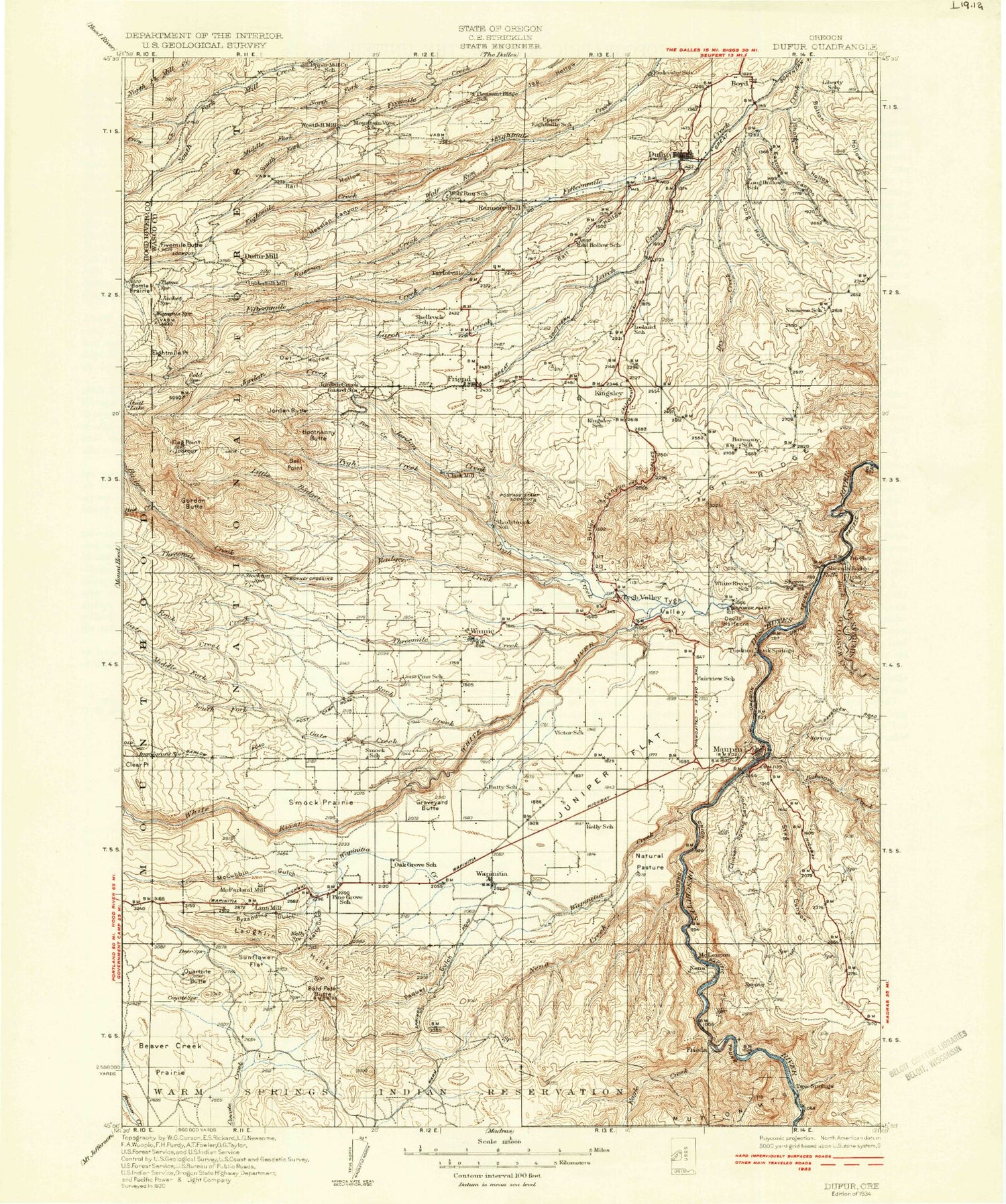
Historical USGS topographic map of Dafur in the state of Oregon. Scale: 1:125000. Print size: 17" x 24"
This map was published in 1934 and is in the following counties: Hood River, Sherman, Wasco.
The map contains contour lines, roads, rivers, towns, streams, and lakes. Printed on high-quality waterproof paper with UV fade-resistant inks.
Contains the following named places: Salt Springs Canyon, Adkisson Creek, Bakeoven Creek, Booten Creek, Boyd, Buck Hollow Creek, Buck Hollow, Butler Canyon, Chicken Spring Canyon, Devil Canyon, Dufur, Eagle Creek, East Maupin, Easton Canyon, Elder Creek, Henderson Hollow, Hicks Creek, Highline Ditch, Kerr Canyon, Kingsley, Long Hollow, Lousey Hollow, Maupin, Mays Canyon Creek, Nansene Community Hall, Natural Pasture, Nye Creek, Oak Creek, Oak Springs Creek, Postage Stamp Butte, Rainbow Quarry, Ramsey Hall, Salt Creek, Sherars Bridge, Shotgun Hollow, Spring Creek, Stag Canyon, Starveout, Stubb Hollow, Tooter Creek, Trail Hollow Creek, Tuskan, Two Springs Ranch, Tygh Ridge, Tygh Ridge Summit, Tygh Valley, Tygh Valley Fairgrounds, Willow Canyon, Winter Water Creek, Wolf Run, Merrell Reservoir, Gray Reservoir, Sherars Falls, Smith Ponds, Gurley Canyon, Nansene, Pine Hollow, Lauronzon Canyon, Dufur Orchards Reservoir, Dufur Ditch, Chase Reservoir, Starveout Creek, Lady Frances Mine, Roberts Reservoirs, Cambrai, Devils Halfacre, Dixon, Endersby, Oak Springs, Sherar, Tygh Valley, Alder Creek, Badger Creek, Badger Creek Trail, Bald Peter Butte, Ball Point, Ball Point Trail, Bonney Crossing, Bottle Prairie Trail, Bulo Point, Byzandine Gulch, Camp Baldwin, Camp Friend, Camp Morrow, Cedar Creek, Clear Point, Camp Cody, Cold Point, Crow Creek, Deadman Gulch, Drop Creek, Dufur City Reservoir, Eightmile Meadow, Eightmile Point, Fifteen Mile Recreation Site, Fifteenmile Creek Trail, Fivemile Butte, Flag Point, Foreman Point, Frailey Point, Frailey Point Trail, Fret Creek, Gate Creek, Goat Creek, Gordon Butte, Gordon Butte Trail, Graveyard Butte, Happy Ridge, Hazel Hollow, Hesslan Canyon, Highland Ditch, Hootnanny Point, Joes Point, Johns Mill Trail, Jordan Butte, Jordan Creek, Jordan Cutoff Trail, Juniper Flat, Kelly Gulch, Larch Creek, Laughlin Hills, Little Badger Recreation Site, Little Badger Creek, Little Badger Creek Trail, Lost Boulder Ditch, Lower Eightmile Crossing Recreation Site, Marion Creek, Marion Point, McCubbins Gulch, Middle Fork Fivemile Creek, Nena Creek, North Fork Fivemile Creek, North Fork Rock Creek, Oval Lake, Owl Hollow, Paquet Gulch, Pebble Ford Recreation Site, Pen Creek, Pen Point, Pen Way Trail, Perry Point, Pine Creek, Pine Creek, Pine Grove, Pleasant Ridge, Pup Creek, Quartz Butte, Rail Hollow, Rail Hollow, Rainbow Quarry, Ramsey Creek, Red Lake, Rock Creek, Rock Creek Reservoir, Simnasho Butte, Smock Prairie, South Fork Fivemile Creek, Souva Creek, Steeds Crossing, Sunflower Flat, Threemile Creek, Threemile Ditch, Threemile Trail, Tygh Creek, Tygh Creek Trail, Wamic, Wapinitia, Wapinitia Creek, White River, Wildcat Creek, Wolf Run Ditch, Pine Hollow, Dry Creek, Kelly Lateral, Rice Creek, Wapinitia Canal, Miller Reservoir, Rock Creek Ditch, Pine Hollow Reservoir, Cody Ponds, Hill Bench, Smarts Reservoir, North Fork Gate Creek, Sherar Springs Creek, Wolf Run, Tamarack Creek, Spring Gulch, Marvel Reservoir, Liechti Pond Number One, Kelly Cistern, Knebal Spring Recreation Site, Springer Ridge, Rainbow Rock, Rock Creek Dam, Helen Lake, Wasco County, Crow Creek Dam, Crow Creek Reservoir, Miller Dam, Pine Hollow Dam, Bonney Crossing Recreation Site, Cascade Hyland Resort, Badger Creek Wilderness, Rock Creek Reservoir Work Center, Rock Creek Campground, Rock Creek Recreation Site, Hillary Grade, Nena, Orchard Ridge Ditch, North Fork Hazel Hollow, Bus Point, South Fork Gate Creek, Springer Ditch, Kerr Creek, Camp Baldwin Lake, Tygh Valley Storage Dam, Tygh Valley Storage Pond, McCubbins Gulch Recreation Site, Hendricks Reservoirs, White River Falls State Park, Eightmile Crossing Recreation Site, Boundary Log Scaling Station, Underhill Recreation Site, Dant, Chicken Spring Canyon, Pine Hollow, Dufur Division, City of Dufur, City of Maupin, Dufur Sewage Treatment Plant, Maupin Wastewater Treatment Plant, Wamic Water and Sewer Authority, Wasco County Fairgrounds, Harpham Flat Boat Launch, Sandy Beach Boat Launch, Pine Hollow Reservoir Boat Ramp South


