
MyTopo
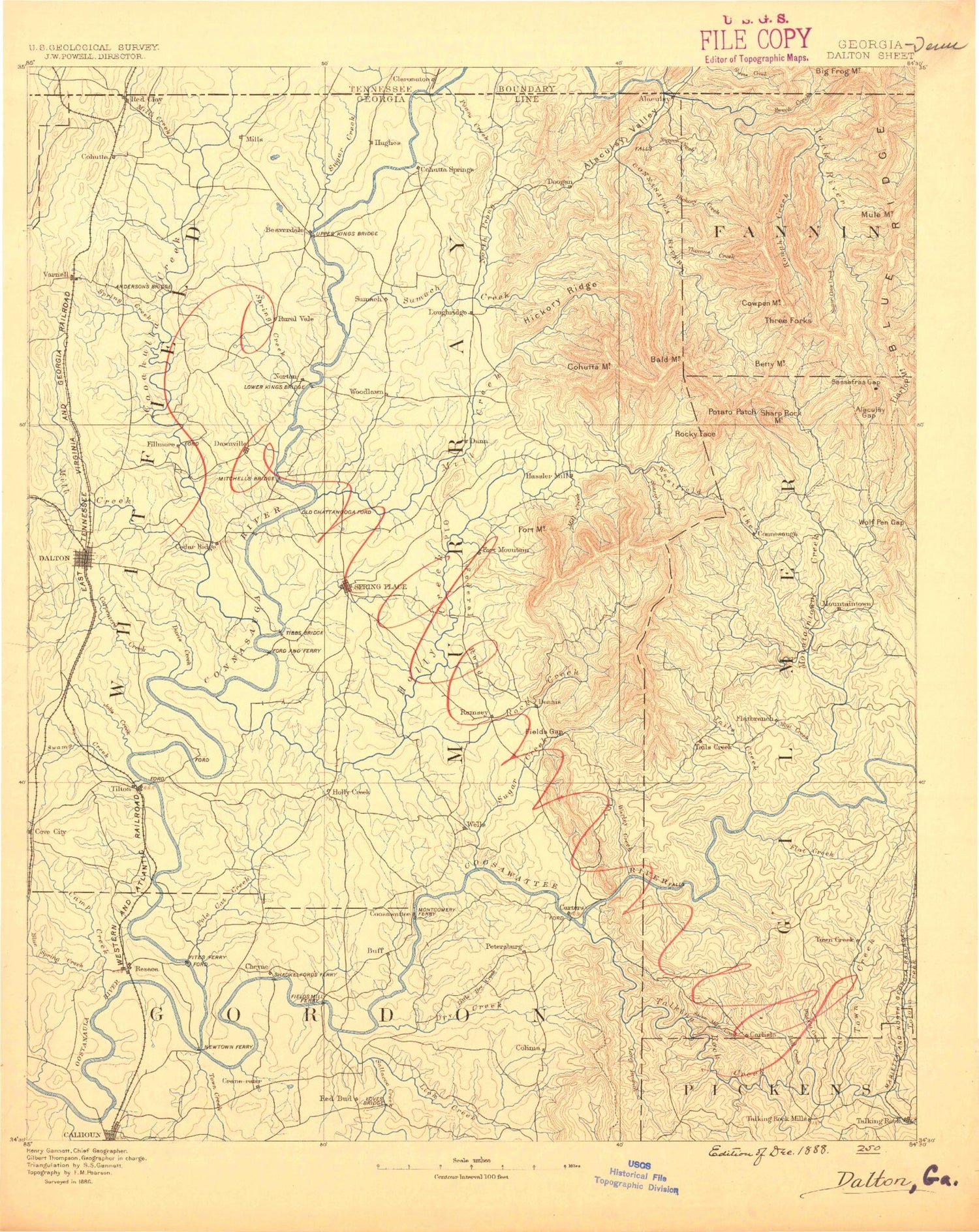
Historic 1886 Dalton Georgia 30'x30' Topo Map
Couldn't load pickup availability
Historical USGS topographic map of Dalton in the state of Georgia. Scale: 1:125000. Print size: 16" x 24"
This map was published in 1886 and is in the following counties: Bradley, Catoosa, Fannin, Gilmer, Gordon, Hamilton, Murray, Pickens, Polk, Whitfield.
The map contains contour lines, roads, rivers, towns, streams, and lakes. Printed on high-quality waterproof paper with UV fade-resistant inks.
Contains the following named places: Ball Creek, Camp Branch, Carters Dam, Crump Creek, Dry Creek, Duke Creek, Fausett Creek, Fisher Creek, Harris Creek, Jackson Branch, Johnson Creek, Lewis Branch, Lick Creek, Little Dry Creek, Little Scarecorn Creek, Long Branch, Mud Creek, Oakman, Pickett Branch, Raccoon Branch, Red Bone Ridges, Redbud Creek, Reregulation Reservoir, Salacoa Creek, Scarecorn Creek, Sevenmile Creek, Stewart Branch, Talking Rock Creek, Talona Creek, Wildcat Creek, Wolf Branch, Audubon, Carns Mill, Colima, Fidelle, Hunts Corner, Lewis Corner, McDaniel, Petersburg, Buzzard Roost Creek, John Rogers Creek, Adams Pond, Alaculsy, Alaculsy Gap, Alaculsy Valley, Baker Branch, Bald Mountain, Banks Branch, Barnes Creek, Barnes Gap, Bartlett Branch, Bates Branch, Beamer Creek, Bear Branch, Bear Branch, Bear Creek, Bearpen Branch, Beaver Mountain, Beech Bottom, Beech Creek, Betty Creek, Betty Gap, Big Jack Creek, Blue Branch, Blue Hole, Bogden Creek, Brackett Ridges, Brown Pond, Buck Creek, Bullpen Branch, Camp Creek, Camp Maynard, Campbell Branch, Carroll Creek, Carters Lake, Casey Springs Branch, Cave Hollow, Cedar Ridge, Cedar Ridge, Chatsworth, Cherokee Indian Memorial, Chicken Coop Gap, Chicken Creek, Coffey Lake, Cohorn Branch, Cohutta Overlook, Cohutta Ridge, Cohutta Springs Branch, Coley Creek, Conasauga Creek, Conasauga Lake, Conasauga River, Cowpen Mountain, Crenshaw Branch, Crenshaw Gap, Crooked Branch, Crow Valley, Crow Valley Creek, Dally Gap, David Pond, Davis Creek, Dead Mans Branch, Demps Creek, Dill Creek, Doe Branch, Dry Branch, Dry Creek, Dry Prong, Duck Branch, Dyer Creek, Dyer Gap, East Fork Beech Creek, Emery Branch, Emery Creek, Fairy, Fairy Valley, Falls Branch, Farrar Branch, Fashion, Felkers Island, Fincher Bluff, Fir Creek, Fisher Creek, Flat Branch, Flat Creek, Folsom Branch, Fort Mountain Lake, Fort Mountain State Park, Lake Frances, Gap Spring Ridge, Gizzard Branch, Goble Branch, Goldmine Branch, Graham Creek, Grassy Mountain, Gryder Camp, Gryder Camp Trail, Gunstock Branch, Hagin Branch, Haig Mill Lake, Halloway Gap, Hammond Creek, Hampton Island, Harkins Creek, Harper Creek, Head Branch, Hemp Top, Hickey Gap, Hickory Creek, Hickory Ridge, Hickory Ridge, High Top, Holly Creek Gap, Horseshoe Bend, Horseshoe Bend, Howell Creek, Hughes Branch, Hungry Valley, Hunsucker Branch, Hurricane Branch, Jacks River, Jigger Creek, Jobs Creek, Ken Mountain, Kenyon Creek, Ketchum Branch, Kiker, Law Grounds, Lawground Branch, Leadmine Branch, Lick Branch, Lick Creek, Little Bear Creek, Little Creek, Little Creek, East Mountaintown Creek, Little Sugar Creek, Little Swamp Creek, Logan Branch, Long Branch, Long Gap, Loopers Bend, Lost Branch, Lost Cove Branch, Lyles Ridge, Mastern Cut, McIntire Branch, McLellan Creek, Mill Branch, Mill Creek, Mill Creek, Mill Creek, Mills Creek, Milma Branch, Mineral Springs Branch, Moody Branch, Moss Lake, Mountaintown Creek, Muddy Branch, Mulberry Gap, Murr Branch, Murray Creek, Murrays Lake, Muskrat Creek, Neal Branch, New Echota Historical Site, Nickolson Branch, Noblet Creek, North Prong Sumac Creek, Norton, Oak Grove Branch, Ollie, Paint Bank Gap, Painter Gap, Panther Bluff, Panther Creek, Parks Ridge, Parr Branch, Patterson Gap, Penitentiary Branch, Peter Cove, Pettiet Branch, Pinhook Creek, Pitner Branch, Pleasant Gap, Polecat Creek, Poplar Spring Creek, Poplar Camp Creek, Pounding Mill Branch, Prater Island, Pratersville, Rainbow Lake, Randolph Island, Rice Camp Branch, Rich Cove, Rich Cove Gap


