MyTopo
Historic 1890 Dardanelle Arkansas 30'x30' Topo Map
Couldn't load pickup availability
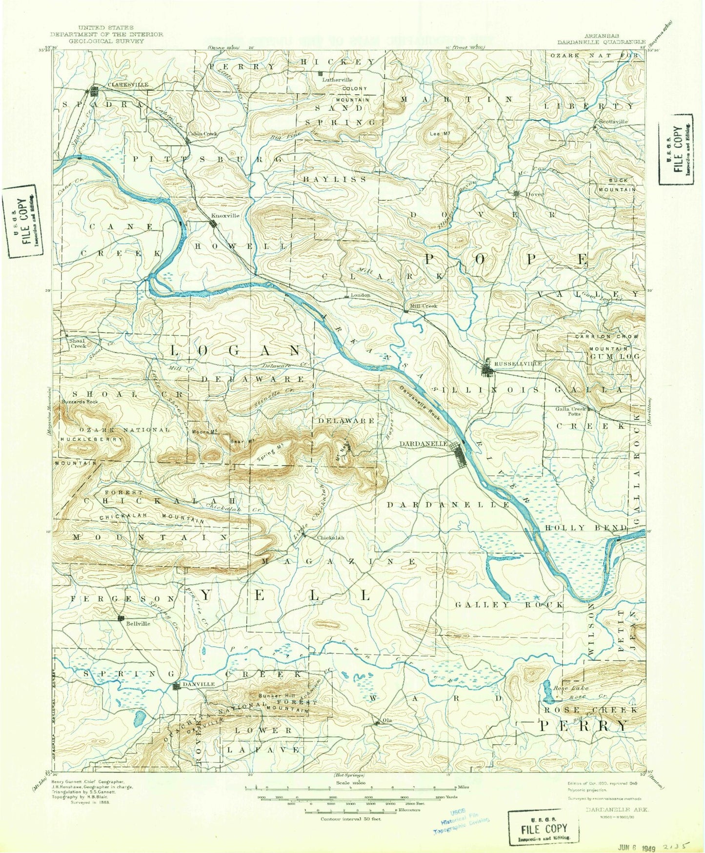
Historical USGS topographic map of Dardanelle in the state of Arkansas. Scale: 1:125000. Print size: 18" x 24"
This map was published in 1890 and is in the following counties: Conway, Johnson, Logan, Perry, Pope, Yell.
The map contains contour lines, roads, rivers, towns, streams, and lakes. Printed on high-quality waterproof paper with UV fade-resistant inks.
Contains the following named places: Bald Knob, Barger Ridge, Bee Bluff, Big Creek, Birta, Booger Hollow, Bryant Branch, Bryant Cove, Bunker Hill, Cedar Creek, Chimney Rock, Choate George Branch, Crooked Branch, Cuba Bottom, Dardanelle Rock, Dean Reid Knob, Galla Creek State Wildlife Management Area, Hambright Creek, Harris Creek, Hayes Creek, Holla Bend Cutoff, Holla Bend National Wildlife Refuge, Huckleberry Creek, Jackson Bluff, Jamestown, Keeland Creek, Keeland Slough, Keeland Slough, Liberty Hall, Little Hayes Creek, Mill Creek, Opossum Branch, Perry Bluff, Pleasant View Mountain, Point Bar Cutoff, Pole Pin Creek, Pond Creek, Prairie Creek, Ragon Mountain, Rose Creek, Sadler Bend, Santa Fe Ridge, Shiloh Creek, Slover Creek, Smiley Bayou, Spring Slough, Sulphur Creek, Tanyard Branch, Tokalon, Ward Creek, Wheeler Bend, Whig Creek, Wilson Creek, Center Valley, Holla Bend, Knoxville Junction, Lutherville, Prosperity, Augsburg, Bernice, Bethel, Casa, Centerville, Cotton Town, Cove Mountain, East Point Mountain, Fowler, Garrett, Hickeytown, Hobsons Knob, Holman, Jones Mountain, Knoxville, Lakeview, Lee Mountain, Linker Mountain, Lutherville Mountain, Norristown Mountain, Parker Mountain, Petit Jean, Pontoon, Ross Mountain, Round Mountain, Shinn Mountain, Spadra, Tater Knob, Thompson Mountain, Tucker Mountain, Horton Mountain, Ross Gas Field, Knoxville Extension Gas Field, Tates Island Gas Field, New Hope Gas Field, College Hill, Mud Creek, Gum Creek, Dover Gas Field, Broomfield, Scottsville Gas Field, Lake Dardanelle State Park, Russellville Boat Dock Area, Mill Creek, Shiloh, Lake Dardanelle State Park - Ouita Area, Ouitaville, Chactas Prairie, Williamsburg Court Shopping Center, Southgate Regional Shopping Center, Dam Site Public Use Area, Hickey Park, Russellville Metro Mall Shopping Center, City Park, Taral, Galla Creek Lake, Moreland Gas Field, Sweeden Island Park, Spadra Gas Field, Saint Scholastica, Dublin Park, Rocky Branch, Flat Rock Use Area, Knoxville Gas Field, Sherwood Shopping Center, Township of Petit Jean, Township of Howell, Township of McKennon, Township of Pittsburg, Township of Spadra, Ard, Bethel, Caroline Branch, Carter Branch, Dardanelle Boat Dock Area, Delaware Park, Mount Nebo, Oak Grove, Open Slough, Rock Creek, Spring Lake Recreation Area, Township of Cane Creek, Township of Delaware, Township of Shoal Creek, Township of Casa, Township of Bayliss, Township of Clark, Township of Dover, Township of Galla, Township of Illinois, Township of Martin, Township of Phoenix, Township of Valley, Township of Centerville, Township of Danville, Township of Dardanelle, Township of Ferguson, Township of Galla Rock, Township of Magazine, Township of Mason, Township of Mountain, Township of Prairie, Township of Sulphur Springs, Township of Ward, Pope County, Yell County, Howells Bend, Neelys Bend, Big Shoal Creek, Nimrod State Wildlife Management Area, Achmun Creek, Alpha, Bailey Branch, Bear Mountain, Belleville Ridge, Bend, Blackman Hollow, Bluebaugh Hill, Bob Barnes Branch, Booze Hollow, Box Spring Branch, Brock Creek, Bunker Hill, Burton Bluff, Buzzards Rock, Cabin Creek, Cane Island, Cane Island Slough, Cape Slough, Carter Mountain, Cave Branch, Cedar Bottom, Charlie Rollans Mountain, Chickalah, Chickalah Creek, Chickalah Mountain, Christian Ridge, Clubb Hill, Coker Creek, Collins Shoals, Colony Mountain, Copper Branch, Corinth, Crossroads, Danville Mountain, Deadman Creek, Delaware, Delaware Creek, Dooley Branch, Dowel Town Ridges, Dry Branch, Dry Fork, Dublin, Earles Branch, Egypt Hollow, Elm Root Slough, Few Branch, Flat Rock, Flat Rock Creek, Fox Lake, Gobblers Knob, Goose Island, Grace Creek, Greenbrier Creek, Gum Tree, Haags Hollow, Harkey Valley, Harris Chapel, Hickerson Hollow, Hickory Grove, High Point, Horn Branch, Huckleberry Mountain, Jim White Ridge, Johnson, Jones Creek, Jones Ridge, Jordan Branch