MyTopo
Historic 1895 Dayton Wyoming 30'x30' Topo Map
Couldn't load pickup availability
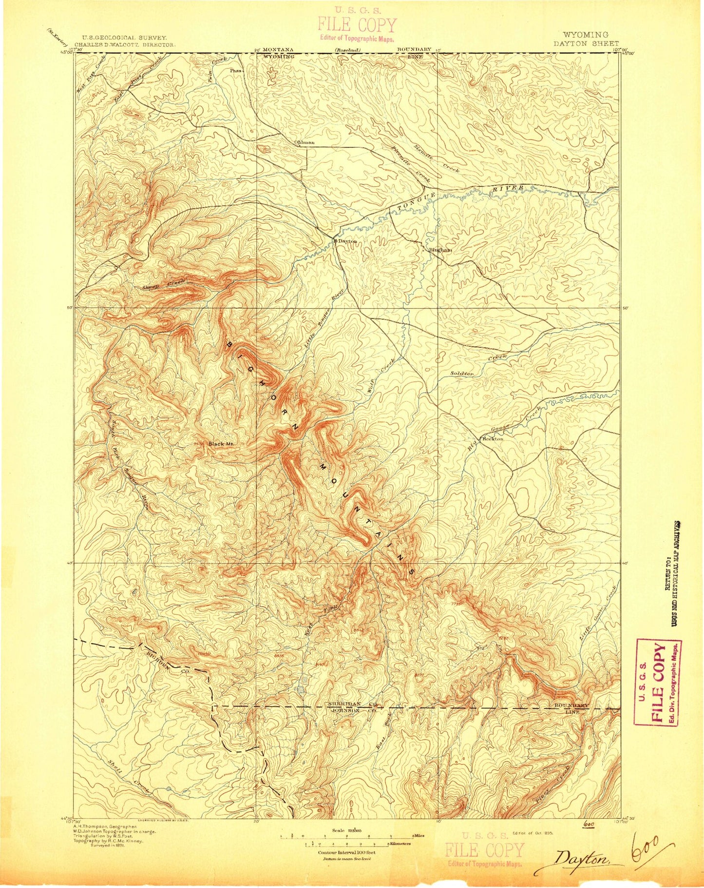
Historical USGS topographic map of Dayton in the state of Wyoming. Scale: 1:125000. Print size: 17" x 24"
This map was published in 1895 and is in the following counties: Big Horn, Johnson, Sheridan.
The map contains contour lines, roads, rivers, towns, streams, and lakes. Printed on high-quality waterproof paper with UV fade-resistant inks.
Contains the following named places: North Branch Slater Creek, South Branch Slater Creek, Lake Alibi, Antwerp Reservoir, Barker Reservoir, Bear Claw Ranch, Black Rib, Bonanza Creek, Brand Point Ditch, Lake Buffalo, Bulls Eye Point, Church Ditch, Columbus Peak, Coney Creek, Coney Lake, Cooper Draw, Crescent Lake, Crystal Spring Draw, Currant Draw, Dan Draw, Dayton, Deer Park, Dome Lake, Dome Lake Reservoir, Dome Rock, Dry Creek, Dry Twin Creek, Duck Pond, Lake Dunchi, Earley Creek, East Fork Earley Creek, East Fork East Pass Creek, East Fork Little Tongue River, Elephant Foot, Elk Pass, Elk Peak, Fallen City, Fivemile Creek, Fivemile Ditch, Fivemile Reservoir, Lake Fontanalis, Gannon Draw, Geddes Lake, Grande Gulch, Gregg Draw, Grouse Draw, Gwinn Draw, Hairpin Turn, Hanover Ditch, Heart Lake, Herdrick Ridge, Hope Lake, Horseshoe Mountain, Horseshoe Ranch, Hultz Draw, Huntington Reservoir, I X L Ranch, Jack Bill Draw, Jenkins Draw, Jensen Draw, Little Ash Creek, Lost Lake, Magpie Gulch, Mikado Ditch, Lake Mirage, Mock Ditch, Mock Gulch, North Fork Earley Creek, Owens Ditch, Oz Ditch, Padlock Ranch, Porcupine Creek, Ranchester, Rinehart Lakes, Rock Chuck Pass, Saddle Mountain, Sand Turn, Lake Shamrock, Sheep Draw, Sixmile Creek, Snail Creek, South Branch Slater Creek, South Fork Earley Creek, South Fork Fivemile Creek, Steam Shovel Draw, Steamboat Point, Steele Reservoir, Stoops Draw, Stull Lakes, Tiny Draw, Tongue Butte, Tongue Canyon, Tongue Canyon Campground, Tongue River Campground, Tongue River Ditch, Trail Creek, Turkey Creek, Twin Lakes Campground, Valley Draw, Wagner Draw, Weston Point, Weston Reservoir, Wilderness Creek, York Ditch, North Branch Slater Creek, Bighorn Mountains, Lightner Creek, Monarch, Parkman, Preacher Rock, Adelaide Creek, Adelaide Lake, Alden Creek, Alder Gulch, Alliance Ditch, Alliance Lateral, Amsden Creek, Antelope Butte, Antelope Creek, Antler Creek, Apple Run, Lake Arden, Arrowhead Lodge, Babione Creek, Baker Creek, Baker Draw, Barr Draw, Bear Creek, Bear Gulch, Beaver Creek, Beaver Creek Hills, Beckton, Big Goose and Beaver Ditch, Big Goose Campground, Big Goose Park, Big Goose Ranger Station, Big Mountain, Bishop Mine, Black Canyon, Black Mountain, Blue Creek, Bonanza Creek, Bosin Rock, Box Canyon, Bruce Creek, Bruce Mountain, Buck Creek, Buckley Creek, Calvin Lake, Camp Bethal, Camp Creek, Carr Cabin, Cave Creek, Claussen Creek, Coffeen Creek, Coffeen Park, Compartment Creek, Copper Creek, Crooked Creek, Crooked Creek Hill, Cross Creek, Cross Creek Campground, Cross Creek Reservoir, Curlew Hill, Cutler Creek, Cutler Hill, Darlington Draw, Davis Creek, Decker Ditch, Diamond Creek, Dome Peak, Dry Gulch, Dry Owen Creek, Duncan Lake, Duncan Lake, Dye-Shields Ditch, East Fork Big Goose Creek, East Fork Davis Creek, East Fork Little Goose Creek, East Fork Sheep Creek, East Fork South Tongue River, East Wolf Creek, East Woodrock Campground, Edelman Creek, Elk Draw, Falls Creek, Finger Rock, Folly Ranch, Fool Creek, Forbes Draw, Freeze Out Cow Camp, Freeze Out Point, Gallatin Cow Camp, Gallatin Draw, Game Creek, Garber Draw, Garrard Ditch, Gloom Creek, Government Gap, Granger Reservoir, Granite Park, Graves Creek, Graves Lake, Grinnell Ditch, Hammel Draw, Hanff Reservoir, Hazel Park, Heidley Park, Hill Creek, Hilman Creek, Horse Creek, Horse Creek Ridge, Hurlburt Creek, Johnson Creek, Kane Draw, Kinney Wood Park, Lamburger Rock, Last Chance Ditch, Last Chance Reservoir, Little Goose Campground, Little Goose Peak, Little Mountain, Little Rapid Creek, Little Tongue River, Loch Creek, Lone Star Creek, Lookout Mountain, Lowe Draw, Mail Creek, Marcum Creek, Martin Reservoir, McKinnon Creek, Middle Fork East Pass Creek, Middle Fork Sheep Creek, Mills Creek, Mohawk Creek