
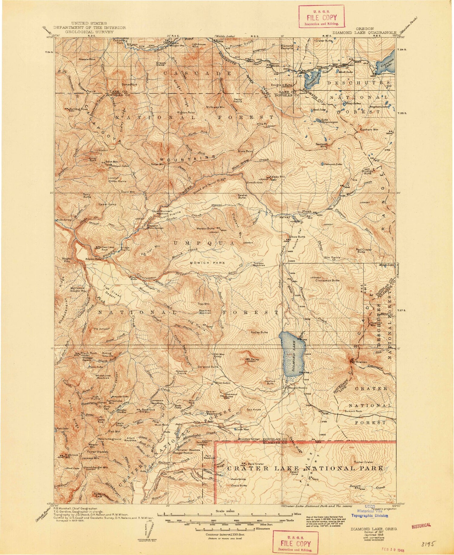
MyTopo
Historic 1917 Diamond Lake Oregon 30'x30' Topo Map
Couldn't load pickup availability
Historical USGS topographic map of Diamond Lake in the state of Oregon. Scale: 1:125000. Print size: 18" x 24"
This map was published in 1917 and is in the following counties: Douglas, Klamath, Lane.
The map contains contour lines, roads, rivers, towns, streams, and lakes. Printed on high-quality waterproof paper with UV fade-resistant inks.
Contains the following named places: Slide Creek, Lost Creek, Muir Creek, Pumice Flat, Tipsoo Peak, Clearwater Number One Forebay Dam, Hollys Ridge, Bingham Meadow, Effie Lake, Contorta Point, Minnehaha Camp, Muir Camp, Whitehorse Falls, Bear Creek, Thielsen Camp, Watson Saddle, Deer Creek Diversion Dam, Davey Creek, No Tunnel Creek, Fish Creek Canal, Clearwater Canal Number 2, Cinder Prairie, Ringtail Pond, Watson Ridge, Lemolo Canal Number 1, Mutton Meadow, West Fork Tumblebug Creek, Royal Creek, Fizz Creek, Sacandaga Recreation Site, Millie Creek, Shelter Creek, Little Dome Creek, Bear Camp, Boulder Creek Wilderness, Marie Lake, Oasis Butte, Alameda Lake, Alkali Creek, Alkali Meadows, Alpine Lake, Andy Lake, Bald Crater, Balm Mountain, Basket Butte, Bear Creek, Beartrap Meadow, Beartrap Trail, Beartree Creek, Beaver Creek, Beaver Marsh, Beaver Meadows, Beaver Meadows Trail, Beaver Shelter, Beverly Creek, Big Pine Opening, Big Swamp, Bingham Lakes, Birds Point, Black Rock, Black Rock Creek, Black Rock Trail, Bobs Bay, Boulder Creek Trail, Bradley Creek, Bradley Lake, Bradley Trail, Bristow Prairie, Bristow Trail, Brodie Creek, Buck Canyon, Buck Canyon Trail, Buck Rock, Buckneck Mountain, Bulldog Prairie, Bulldog Rock, Bunker Hill, Calamut Lake, Calamut Way, Calapooya Trail, Camas Creek, Camel Hump, Camp Creek, Camp Creek Forest Camp, Campers Flat, Cascade Creek, Castle Rock, Lake Charline, Chinquapin Creek, Cinder Prairie Lookout, Cinder Prairie Way, Cinnamon Butte, Clear Creek, Clearwater, Clearwater Falls, Clearwater River, Cougar Ridge, Cowhorn Creek, Cowhorn Mountain, Crater Butte, Crescent Lake Recreation Site, Crescent Ridge, Deadwood Creek, Deer Creek, Deer Leap Rock, Desert Cone, Desert Ridge, Devils Canyon, Devils Slide, Diamond Lake, Diamond Lake, Diamond Rockpile, Dog Prairie, Dog Prairie Creek, Dog Prairie Trail, Dome Creek, Dome Rock, Dorothy Creek, Dread and Terror Ridge, Eva Creek, East Fork Muir Creek, Echo Creek, Echo Creek Trail, Elbow Butte, Elephant Mountain, Emigrant Butte, Emigrant Creek, Emigrant Forest Camp, Emigrant Pass, Falls Creek, Farrell Lake, Fawn Lake, Fish Creek Desert, Fish Creek Shelter, Fish Creek Valley, Fish Lake Trail, Fish Mountain, Flatiron Point, Foster Glades, Fuller Lake, Garwood Butte, Gaywas Peak, Grassy Glade, Grave Creek, Grave Creek Trail, Gravel Creek, Hamaker Bluff, Hamaker Butte, Hamaker Creek, Hamaker Meadows, Happy Prairie, Happy Prairie Way, Happy Valley, Helen Creek, Hemlock Butte, Hemlock Lake, Hershberger Mountain, High Prairie, Highrock Creek, Highrock Mountain, Hills Peak, Hole in the Ground, Horse Creek, Horse Lake, Howlock Mountain, Hummingbird Creek, Hunter Creek, Hurryon Creek, Ice Creek, Indian Creek Trail, Indigo Creek, Indigo Lake, Jackass Mountain, June Lake, Kelsay Mountain, Kelsay Point, Kelsay Valley, Kelsay VAlley Recreation Site, Kelsay Way, Klamath Ridge, Lake Creek, Lake Creek Forest Camp, Laura Creek, Lava Creek, Lemolo Falls, Lemolo Lake, Lighthouse Rock, Little Dome Rock, Lizard Lake, Loafer Creek, Log Creek, Log Pile Trail, Loletta Lakes, Lonesome Creek, Lonesome Meadow, Lost Camp Trail, Lost Creek, Lake Lucile, Maidu Lake, Maidu Lake Way, Maple Creek, Maple Creek, Mazama Creek, McGowan Mountain, McGowan Mountain Way, McLean Mountain, Meadow Creek, Meadow Creek Trail, Medicine Creek, Meek Lake, Middle Fork National Creek, Mill Creek, Minnehaha Creek, Minnehaha-Hurryon Trail, Mosquito Lake, Mount Bailey Trail, Mountain Creek, Mountain Meadows, Mountain Meadows Trail, Mowich Creek, Mowich Park, Mud Lake Mountain, Mule Peak, Nancy Creek, National Creek, Nip and Tuck Lakes, Norma Creek, North Fork Staley Creek, Nurse Creek, Old Burn Way, Old Man Camp, Opal Lake, Paddys Valley, Park Meadows, Patricia Creek, Perry Butte


