MyTopo
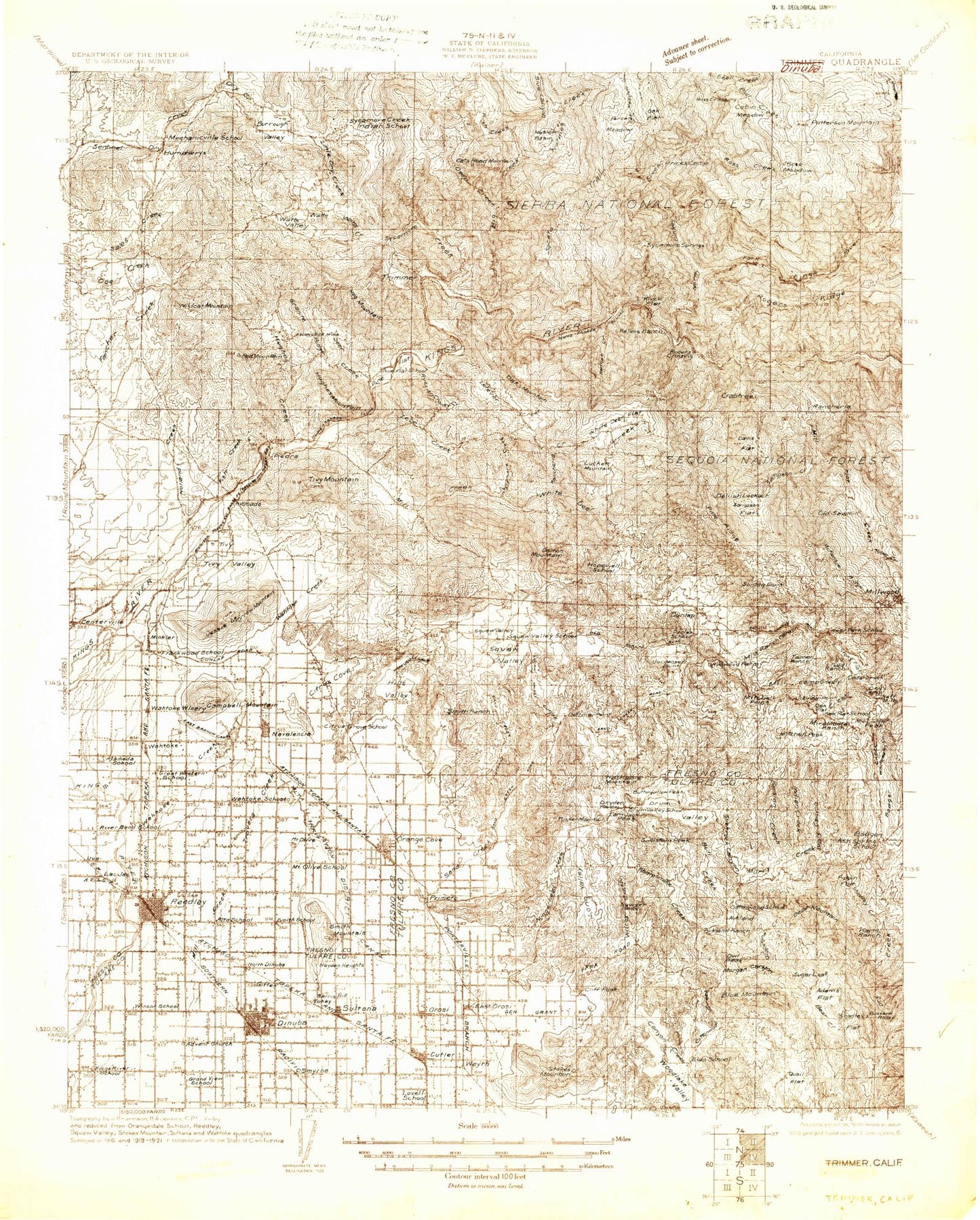
Historic 1922 Dinuba California 30'x30' Topo Map
Couldn't load pickup availability
Historical USGS topographic map of Dinuba in the state of California. Scale: 1:96000. Print size: 24" x 27"
This map was published in 1922 and is in the following counties: Fresno, Tulare.
The map contains contour lines, roads, rivers, towns, streams, and lakes. Printed on high-quality waterproof paper with UV fade-resistant inks.
Contains the following named places: A H Smith Ditch, Adams Flat, Adams Gap, Alta East Branch Canal, Alta Main Canal, Alta West Clark Ditch, Andrews Ditch, Auckland Ranch, Avocado Lake, Baker Ranch, Bear Flat, Bear Meadow Creek, Bear Mountain, Bill Moore Canyon, Bill Moore Ridge, Billy Creek, Blue Canyon, Blue Mountain, Bobs Flat, Bobs Flat Trail, Branford Mountain, Brown Flat, Buck Canyon, Buckeye Creek, Bump and Edmiston Ditch, Burrough Valley, Buttonwillow Peak, Buzzard Roost, Byrd Slough, California Vineyard Ditch, Cameron Slough, Campbell Ditch, Campbell Mountain, Cats Head Mountain, Centerville, Cherry Flat, Citrus Cove, Clara H Mine, Clark Ditch, Cliff Peak, Cole Slough Canal, Collier Cove, Consolidated Canal, Copper King Mine, Corn Jack Peak, Coyote Flat, Coyote Ridge, Davis Creek, Davis Flat, Davis Mountain, Deep Creek, Delilah Lookout, Dinuba Town Ditch, Dixie Ranch, Drum Valley, Dry Valley, Dudley Ranch, Duncan Canyon, Eagle Peak, East Branch Smith Ferry Canal, East Reedley Ditch, El Monte Elementary School, Ellis Mountain, Fence Meadow, Fence Meadow Lookout, Fink Ditch, Fish Creek, Fisher Flat, Fly Creek, Fox Canyon, Francis Flat, Goat Hill, Goldstein Peak, Granite Hill, Granite Ridge, Grapevine Creek, Grapevine Creek, Grapevine Peak, Gravesboro, Green Mountain, Hacker Mountain, Hansen Canal, Harlan Ranch, Haslett Basin, Highland Canal, Hills Valley, Hog Mountain, Holland Creek, Humphreys Station, Jack Thorn Mine, Jackson Ranch, Jesse Morrow Mountain, Jorgensen Point, Kaktus Korner, Ketscher Ranch, Keys Mountain, Kirch Flat, Kirk Ditch, Knestric Ditch, Lakeview Picnic Ground, Lassotovitch Ranch, Lewis Creek, Little Dry Creek, Lonetree Channel, Long Creek, Long Valley, Lovell Ditch, Lower Rancheria Creek, Lucy Runyon Canyon, M-Bar-J Ranch, Mankins Flat, Marble Canyon, McBriar Ditch, McClure Flat, McKenzie Guard Station, McKenzie Ridge, Metcalf Ranch, Mill Flat, Mill Flat Creek, Miller Ditch, Minkler, Monson Ditch, Montague Ditch, Moore Creek Ranch, Morgan Canyon, Murry Flat, Murry Gulch, Nance Ranch, Navelencia, Negro Creek, North Fork Hughes Creek, Nutmeg Creek, Oak Flat, Orosi, Owl Mountain, Pippin Flat, Rancheria, Rancheria Canyon, Rancheria Flat, Rattlesnake Creek, Rector Ranch, Red Mountain, Red Mountain, Red Mountain, Redoak Creek, Reedley Main Canal, Roble Lomas Ranch, Rock House Guard Station, Ross Creek, Rush Creek, Ruth Hill, Sawyer Peak, Shadley Creek, Shannon Valley, Smith Ferry Canal, Smith Mountain, Smith Mountain Ditch, Abbott Creek, Big Creek, Blue Canyon, Buttonwillow Ditch, Deep Creek Trail, Driver Ditch, McGee Ditch, Pine Ridge, Reo Ditch, Stephenson Hill, Stoddard Ranch, Stone Corral Canyon, Story Creek, Sugarloaf, Sycamore Creek, Sycamore Springs Creek, Tivy Valley, Travers Creek, Trimmer Ranger Station, Trimmer Recreation Area, Tucker Mountain, Uva, Verplank Creek, Verplank Saddle, Wahtoke Ditch, Wahtoke Lake, Watts Creek, Watts Valley, West Branch Smith Ferry Canal, West Fork Hughes Creek, West Gould Ditch, West Reedley Ditch, Wilcox Canyon, Wilcox Creek, Wildcat Creek, Wildcat Mountain, Willow Creek, Wilson Ditch, Winton Park, Wooten Creek, Bowhay Ditch, Cary Hunter Ditch, Horsman Ditch, Long Mountain, Loper Ditch, Monson Ditch, Tout Ditch, Pine Flat Lake, Baker Mountain, Shipes Valley, Whale Rock, Wonder Valley, Little White Deer Valley, Little White Deer Creek, Elk, Hoffman Point, Lacjac, Tokay, Wahtoke, Quail Flat, Sacate Creek, Sacate Ridge, Sampson Creek, Sampson Flat, Squaw Valley, Sycamore Flat Campground One, Sycamore Flat Campground Two, Kennedy Wasteway, Bear Creek, Moore Creek, Murry Creek, Badger, Badger Creek, Badger Fire Control Station, Balch Camp, Bald Mountain, Basin Creek, Bear Creek, Bear Mountain