MyTopo
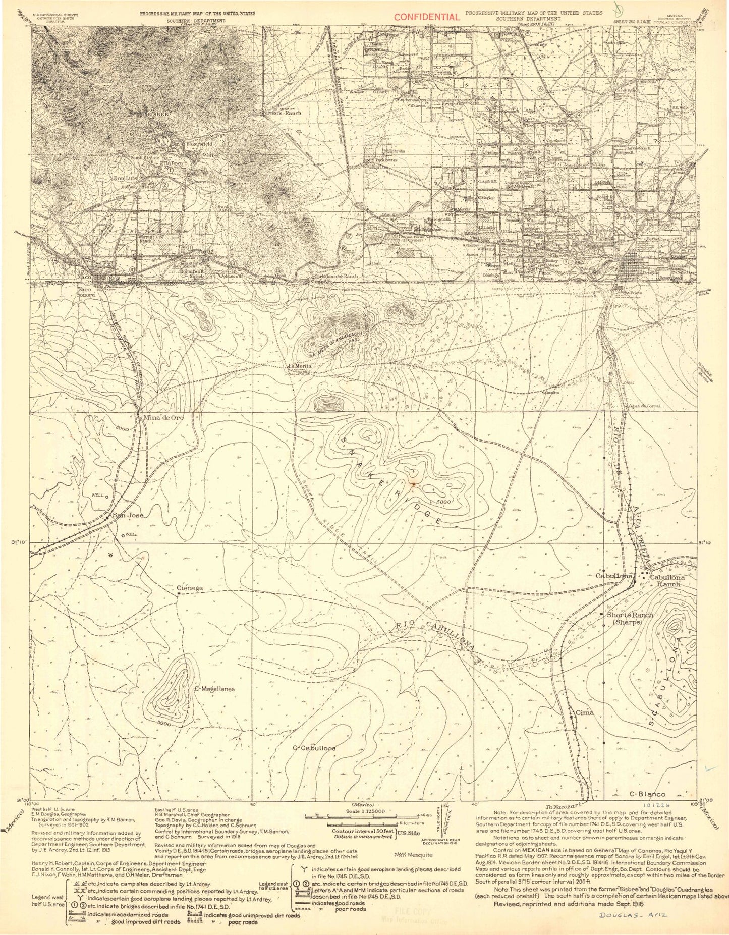
Historic 1916 Don Luis Arizona 30'x30' Topo Map
Couldn't load pickup availability
Historical USGS topographic map of Don Luisin the states of Arizona, New Mexico. Scale: 1:125000. Print size: 17" x 24"
This map was published in 1916 and is in the following counties: Cochise.
The map contains contour lines, roads, rivers, towns, streams, and lakes. Printed on high-quality waterproof paper with UV fade-resistant inks.
Contains the following named places: Abrigo Canyon, Bakerville, Mount Ballard, Banning Toll Station, Bisbee, Bisbee Junction, Bisbee West, Black Gap, Black Knob, Bolsa Canyon, Boras Mine, Brewery Gulch, Briggs, Bucky O'Neill Hill, Calumet Mine, Campbell, Castle Rock, Chihuahua Hill, Christiansen Ranch, Cintura Hill, Cochise, Cole, Cole Number Three, Congdon, Contact, Copper King, Copper King Canyon, Copper King Hill, Copper Queen, Crook Tunnel, Dallas, Dern Mine, Don Luis, Double Adobe, Douglas, Dubacher Canyon, Durazo Canyon, Easter Sunday Mine, Escabrosa Ridge, Escacado Canyon, Fissure Peak, Forrest Ranch, Galena, Galena, Glance Creek, Glance Mine, Goat Ranch, Gold Gulch, Gold Hill, Grassy Hill, Harris Ranch, Hendricks Gulch, Highland Park, Hoatson, Huachuca Terrace, Irish Mag, Ivanhoe Mine, Jones Hill, Juniper Flats, Knob Hill, Korp Canyon, Lazy KJ Ranch, Little Dry Canyon, Lovers Leap, Lowell, Lucky Jack, Marquette Mine, Mount Martin, Mexican Canyon, Moon Canyon, Moore Canyon, Morales Creek, Mud Springs Draw, Mule Gulch, Mule Mountain Ranch, Mule Mountains, Mule Pass, Mural Hill, Naco, Naco Hills, Night Hawk, Oak Thicket Ranch, Old Bisbee West, Paul Spur, Pirtleville, Powell, Quality Hill, Quarry Canyon, Queen Hill, Rancho de Hannon, Rancho San Jose, Red Mountain, Mount Reilly, Rock Creek Ranch, Sacramento Hill, Saginaw, Saginaw, Scherer Canyon, School Hill, Shattuck, Silver Bear, Silver Bear Gulch, South Bisbee, Spring Canyon, Steele Canyon, Stewart Ranch, Sunrise, Superior Mine, The Divide, The Mountain Ranch, Tintown, Tombstone Canyon, Uncle Sam, Uncle Sam Gulch, Wade Hampton Pit, Warren, Warren, Watkins Ranch, Watson Ranch, Wells Ranch, White Tail Deer, Wildcat Canyon, Wildcat Canyon, Wolverine Mines, Wood Canyon, Youngblood Hill, Agua Prieta Substation, Art Hill, Bailey Hill, Cochise County Fairgrounds, Douglas Substation, Fairview Substation, Fifteenth Street Park, Fifth Street Park, Geronimo Trail, Higgins Hill, Laundry Hill, Lavender Open Pit Mine, Mason Hill, Miller Hill, Mule Pass Tunnel, Old City Park - Bisbee, Tank Hill, Tenth Street Park, Wade Hampton Pit Mine, Warren Hill, Williams Hill, Calumet, Corta Junction, Forrest, Neff, Rileys El Encinar, Briggs Sewage Disposal, Copper Queen Smelter, Douglas Golf Course, Bisbee Municipal Golf Course, El Paso Natural Gas Company Compressor Station, City of Bisbee, City of Douglas, Sieling's Mobile Village, Mount Vista Mobile Home Park, Sunspots South Mobile Home Park, Port of Entry Douglas, Turquoise Valley Recreational Vehicle Resort, City of Douglas Municipal Golf Course, Turquoise Valley Golf Park, City of San Jose Wastewater Treatment Plant, Geronimo Trail