MyTopo
Historic 1939 Duchesne Utah 30'x30' Topo Map
Couldn't load pickup availability
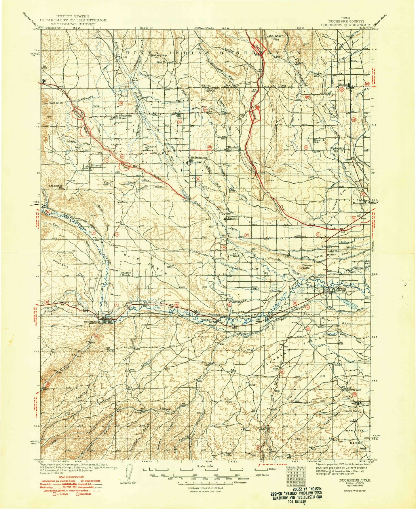
Historical USGS topographic map of Duchesne in the state of Utah. Scale: 1:125000. Print size: 17" x 24"
This map was published in 1939 and is in the following counties: Duchesne.
The map contains contour lines, roads, rivers, towns, streams, and lakes. Printed on high-quality waterproof paper with UV fade-resistant inks.
Contains the following named places: Altamont, Altonah, Antelope Canyon, Benson Draw, Big Hollow, Big Sand Wash, Blue Bench, Bluebell, Bluebell Lateral, Boreham Memorial, Lake Boreham, Butcher Knife, C Canal, Castle Peak, Castle Peak Mine, City Canal, Clay Basin, Clement Hollow, Cottonwood Canyon, Cottonwood Ridge, Coyote Basin, Coyote Canyon, Draper Hollow, Dry Gulch Canal, Duchesne, Duchesne Feeder Canal, F Canal, Flat Top, Flattop Butte, Gray Mountain Canal, Gundy Hollow, Hair Bench, Hancock Cove, Hancock Lateral, Harmston Bench, Indian Canyon, Knight Ditch, Kuntz Hollow, Lake Fork Canal, Lake Fork Extension Canal, Lake Fork Western Canal, Lower Pleasant Valley Canal, Martin Lateral, Midview Ditch, Midview Lateral, Monarch Ridge, Monument Butte Oil Field, Moon Lake Canal, Mount Emmons, Mountain Home, Murray White Canal, Myton, Myton City Reservoir, Myton Pumping Station, Neola, New Hope Canal, North Ditch, North Lateral C Canal, North Lateral Lake Fork Canal, North Myton Bench, P X Ranch, Page Bench, Page Canal, Pahcease Canal, Pahcease Canal, Pariette Mine, Payne Canal, Pine Ridge, Pioneer Canal, Pleasant Valley Canal, Pulley Bend, Purdy Canal, Rabbit Gulch, Red Cap Canal, Riverdell Canal, Rocky Point B Canal, Rocky Point Canal, Roosevelt Lateral, Saleratus Wash, Sand Wash, Sheehan Lateral, Sheep Camp Corral, Snyder Reservoir, South Boneta Canal, South Ditch, South Lateral, South Lateral C Canal, South Lateral Lake Fork Canal, South Myton Bench, Spring Branch Creek, Spring Hollow, Steamboat Mountain, Talmage, The Crescent, Todd Hill, Towanta Flat, Twin Knolls, United States Lake Fork Canal, Upalco, Upper Pleasant Valley Canal, Uteland Canal, Water Hollow, West Bench, Yellowstone Extension Canal, Yellowstone Feeder Canal, Zimmerman Wash, Hancock Reservoir, Hancock Dam, Starvation Dam, Starvation Reservoir, Grant Hansen Reservoir Number Three, Grant Hansen Reservoir Number Three Dam, Big Sand Wash Reservoir, Big Sand Wash Dam, Browns Draw Reservoir, Browns Draw Dam, Cedarview Dam, Benson Creek, Big Sand Lake Campground, Big Sand State Park, Nutter Canyon Oil Field, Sowers Canyon Wildlife Management Area, Arcadia, Boneta, Bridgeland, Cedarview, Ioka, Monarch, Utahn, Antelope Creek, Bald Knoll, Big Draw, Brundage Canyon, Cedarview Canal, Cottonwood Canyon, Cottonwood Wash, Dodd Ditch, Farnsworth Canal, Gilsonite Draw, Lake Fork River, Left Fork Antelope Canyon, Mud Spring Draw, Nutters Canyon, Petty Creek, Pigeon Water Creek, Right Fork Antelope Canyon, Rock Creek, Salt Creek, Sowers Canyon, Strawberry River, Tabby Canyon, Timothy Creek, Uintah Canal, Wells Draw, West Fork Dry Gulch Creek, Wire Fence Canyon, Yellowstone River, Uintah and Ouray Reservation, Duchesne County, Sowers Creek, Starvation Campground, Lateral Number 1, Lateral Number 1, Lateral Number 2, Lateral Number 2, Lateral Number 2 1/2, Lateral Number 3, Lateral Number 3, Lateral Number 4, Lateral Number 4, Lateral Number 5, Lateral Number 5, Number 1 Canal, Starvation State Park, Roosevelt Division, City of Duchesne, City of Roosevelt, City of Myton, Town of Altamont, Rocky Point C Canal