MyTopo
Historic 1935 Dunsmuir California 30'x30' Topo Map
Couldn't load pickup availability
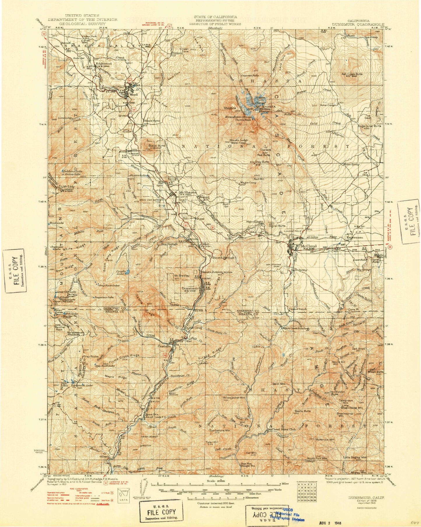
Historical USGS topographic map of Dunsmuir in the state of California. Scale: 1:125000. Print size: 17" x 24"
This map was published in 1935 and is in the following counties: Shasta, Siskiyou, Trinity.
The map contains contour lines, roads, rivers, towns, streams, and lakes. Printed on high-quality waterproof paper with UV fade-resistant inks.
Contains the following named places: Ah-Di-Na, Asbestos Gulch, Ash Camp, Bald Mountain, Bald Mountain Creek, Beartrap Creek, Beaughton Creek, Boles Creek, Bones Gulch, Boulder Peak, Brushy Butte, Butcherknife Creek, Castle Lake, Cedar Lake, Centipede Creek, Claiborne Creek, Claiborne Peak, Cliff Lake, Curl Ridge Jeep Trail, Dale Creek, Deer Creek, Devils Gulch, Devils Pocket, Doodlebug Gulch, Dutch Creek, Echo Lake, Echo Lake Trail, Eddy Creek, Fawn Creek, Fish Creek, Fitzhugh Gulch, Flume Creek, Garden Ridge, Garret Flat, Ghost Camp, Grader Gulch, Gray Rock Lake, Grey Rocks, Hamilton Bend, Happy Hunting Grounds, Hat Mountain, Hat Mountain Creek, Hawkins Creek, Hazel Creek, Heart Lake, Lake Helen, Horned Owl Gulch, Hornet Gulch, Horse Creek, Horse Heaven Meadows, Igerna, Jessie Creek, Ladybug Butte, Ladybug Creek, Little Bagley Mountain, Lower Cliff Lake, Lower Seven Lake, McCloud River Club, McKenzie Mountain, Mears Creek, Mink Creek, Muddy Spring Creek, Mule Shoe, North Fork Hazel Creek, North Fork Mountain, North Fork Tom Neal Creek, Oak Creek, Panther Rock, Pine Flat, Prospect Creek, Root Creek, Satin Peak, Scorpion Gulch, Scott Camp Ridge, Scott Lake, Seven Lakes Basin, Sheep Camp, Sheep Creek, Shoeinhorse Mountain, Smith Creek, Buck Ridge, Chiquito Creek, Soapstone Creek, Soapstone Gulch, Soapstone Pond, South Fork Castle Creek, South Fork Claiborne Creek, South Fork Hazel Creek, Spring Creek, Squaw Valley Creek, Squirrel Creek, Sweetbrier Creek, Sweetbrier Ridge, Tamarack Creek, Tamarack Mountain, Terrace Lake, Timber Lake, Tom Dow Creek, Tom Neal Creek, Trough Creek, Two Pine, Upper Cliff Lake, Upper Gray Rock Lake, Upper Seven Lake, Van Sicklin Butte, West Fork Parks Creek, West Fork Squaw Creek, Whalan Station, White Rock, Yellowjacket Mountain, Sims Lookout, Shasta National Forest, Abrams Lake, Angel Creek, Ash Creek Butte, Avalanche Gulch, Azalea, Battle Creek, Bear Creek, Big Canon, Big Canyon Creek, Big Springs Creek, Bigelow Gulch, Bigelow Meadow, Bolam Creek, Bolam Glacier, Boulder Creek, Mount Bradley, Brewer Creek, Browns Lake, Bunny Flat, Cabin Creek, Castella, Castle Crags, Castle Crags State Park, Castle Creek, Castle Creek Campground, Castle Lake Creek, Castle Lake Trail, Chicken Hawk Hill, Chipmunk Lake, Cinder Cone, Clarence King Lake, Clear Creek, Cold Creek, Cold Creek, Cone Point, Connor Creek, Coquette Falls, Cottonwood Creek, Coyote Gulch, Dairy Creek, Dan Stevens, Deer Creek, Deetz, Diller Canyon, Dobkins Lake, Dropoff Creek, Durney Lake, Mount Eddy, Everitt Hill, Fall Creek, Fan Gulch, Flume Creek Ridge, Fools Gulch, Fowlers Campground, Gap Creek, Girard Ridge, Gravel Creek, Gray Butte, Grey Rock Lake, Harts Camp, Harts Meadow, Hedge Creek, Helen Lake, Hornet Gulch, Hotlum Glacier, Howard, Huckleberry Creek, Inconstance Creek, Indian Creek, Kaiser Meadow, Kettlebelly Ridge, Konwakiton Glacier, Lakin Dam, Lick Creek, Little Castle Creek, Little Castle Lake, Little Crater Lake, Lizard Creek, Log Pond, Lower Falls, McKenzie Butte, Mears Ridge, Middle Falls, Middle Fork Sacramento River, Military Pass, Morgan Meadows, Mossbrae Falls, Mott, Mud Creek Dam, Ney Springs, Ney Springs Creek, North Fork Castle Creek, North Fork Sacramento River, North Fork Shotgun Creek, North Gate, Oak Knob, Panther Creek, Panther Meadow, Pig Creek, Pilgrim Creek, Pine Tree Hollow, Pioneer, Ponto Park, Quail Gulch, Rainbow Ridge, Rattlesnake Hill, Red Banks, Red Fir Ridge, Root Creek, Sand Flat, Sargents Ridge, Sawmill Curve, Scott Camp Creek, Shasta Alpine Lodge, Shasta Springs, Mount Shasta, Shastina, Shingle Creek, Shotgun Creek, Sisson Lake, Slate Ridge Trail, Baker Hollow, Black Butte, Cascade Gulch