MyTopo
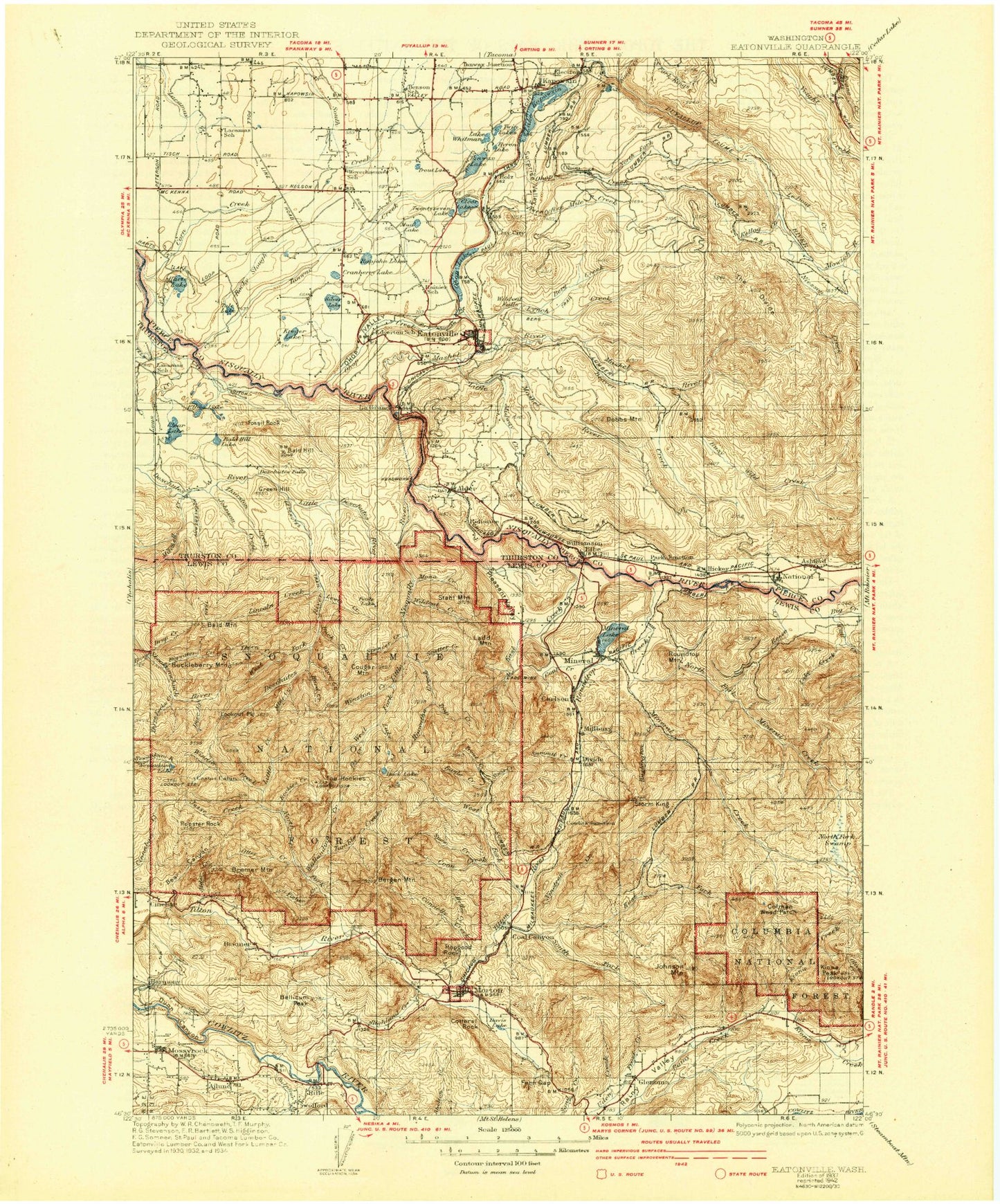
Historic 1937 Eatonville Washington 30'x30' Topo Map
Couldn't load pickup availability
Historical USGS topographic map of Eatonville in the state of Washington. Scale: 1:125000. Print size: 17" x 24"
This map was published in 1937 and is in the following counties: Lewis, Pierce, Thurston.
The map contains contour lines, roads, rivers, towns, streams, and lakes. Printed on high-quality waterproof paper with UV fade-resistant inks.
Contains the following named places: Ajlune, Alder, Alder Creek, Alder Dam, Alder Lake, Anderson Lake, Ashford, Bald Hill, Bald Hill Lake, Bald Mountain, Bass Lake, Bear Canyon, Beaver Creek, Beaver Creek, Bellicum Peak, Benbow Lakes, Berg Creek, Bergen Mountain, Big Creek, Bigwater Creek, Bogucki Island, Bremer, Bremer Mountain, Bromo Creek, Buck Creek, Busy Wild Creek, Byron Lake, Carlson, Catt Creek, Centralia Dam, Charles Lathrop Pack Experimental and Demonstration Forest, Clay City, Clear Lake, Clear Lake, Coal Canyon, Coal Creek, Coleman Weed Patch, Connelly Creek, Coon Creek, Cottlers Rock, Cougar Mountain, Coyote Creek, Cranberry Lake, Davis Lake, Deer Creek, Deschutes Falls, Divide, Dobbs Mountain, Drop Creek, Duck Lake, Dunn Canyon, Eagle Creek, East Creek, East Fork Tilton River, Eatonville, Eatonville Junction, Edna Creek, Elbe, Elbow Lake, Elbow Lake Creek, Electron, Electron Flume, Electron Reservoir, Fern Gap, Fisher Creek, Fly Creek, Fossil Rock, Frost Creek, Gallup Creek, Glenoma, Goose Lake, Green Hill, Hard Creek, Harmony, Harts Lake, Heller Creek, Hiawatha Creek, Highland Creek, Hopgood Rock, Horn Creek, Horseshoe Lake, Huckleberry Mountain, Hugo Peak, Jesse Creek, Jims Corner, Johnson Creek, Johnson Creek, Johnson Mountain, Johnsons Corner, Kapowsin, Lake Kapowsin, Kings Creek, Kiona Peak, Kirkland Pass, Kosmos Lookout, Kreger Lake, La Grande, La Grande Dam, La Grande Reservoir, Lacamas Creek, Lackamas Creek, Ladd Lookout, Ladd Mountain, Lake Creek, Lake Creek, Lake Creek, Le Dout Creek, Lewis Creek, Lincoln Creek, Little Creek, Little Deschutes River, Little Lake, Little Mashel Falls, Little Mashel River, Little Nisqually River, Lookout Peak, Lynch Creek, Mashel Prairie, Mashel River, McKinley Lake, Midway Creek, Mine Creek, Mineral, Mineral Creek, Mineral Lake, Minnie Creek, Mitchell Creek, Mona Creek, Morton, Mossyrock, Mowich River, Mud Lake, National, National Lookout, Neff Ranch, New Reliance, Newaukum Lake, Niesson Creek, Nineteen Creek, North Fork Mineral Creek, North Fork Swamp, North Fork Tilton River, Ohop, Ohop Creek, Ohop Lake, Ohop Valley, Otter Creek, Park Junction, Parsnip Swamp, Pleasant Valley, Point Ohop, Powell Creek, Rainey Valley, Range Creek, Rapjohn Lake, Reese Creek, Reliance, Reliance Hill, Rockies Creek, Rocky Slough, Rooster Rock, Roundtop Mountain, Roundtop Creek, Ruby Creek, Rushingwater Creek, Scatter Creek, Silver Lake, Simmons Creek, Snow Creek, Soap Creek, Soos Creek, South Fork Tilton Creek, Spencer Creek, Stahl Mountain, Stidham Lake, Storm King Mountain, Sulphur Creek, Summit Creek, Surprise Valley, Swofford, Swofford Valley, Tanwax Creek, The Divide, The Rockies, Thorn Creek, Three Forks Creek, Thurston Creek, Tobolton Creek, Trap Creek, Trout Creek, Trout Lake, Tule Lake, Tumble Creek, Twentyfive Mile Creek, Twentyseven Creek Reservoir, Twentyseven Lake, Twin Lakes, Voss Resort, Ware Creek, Washington Creek, West Fork Deschutes River, West Fork Little Nisqually River, West Fork Tilton River, Lake Whitman, Wildcat Creek, Wildcat Falls, Winnie Creek, Winston Creek, Mossyrock Dam, Indian Hole Campground, Ladd Pond, Ladd Camp, Stiltner Creek, Alder Lake Campground, Elbe Ranger Station, Mossyrock Park, Tahoma Woods, Elbe Hills Trailhead, Glenoma Community Park, Hopkins Hill Viewpoint, Kellog Creek, Ohop, Glacier View Park, Newaukum Lookout, National Mountain Lookout, Petite Lake, Storm King Lookout, Huckleberry Mountain Lookout, Ladd Lookout, Ohop Creek Ponds, Ohop Bob, Leber, Fern Gap Guard Station, North Fork Ohop Creek, Lewis County, Swofford Valley Rearing Pond Dam