MyTopo
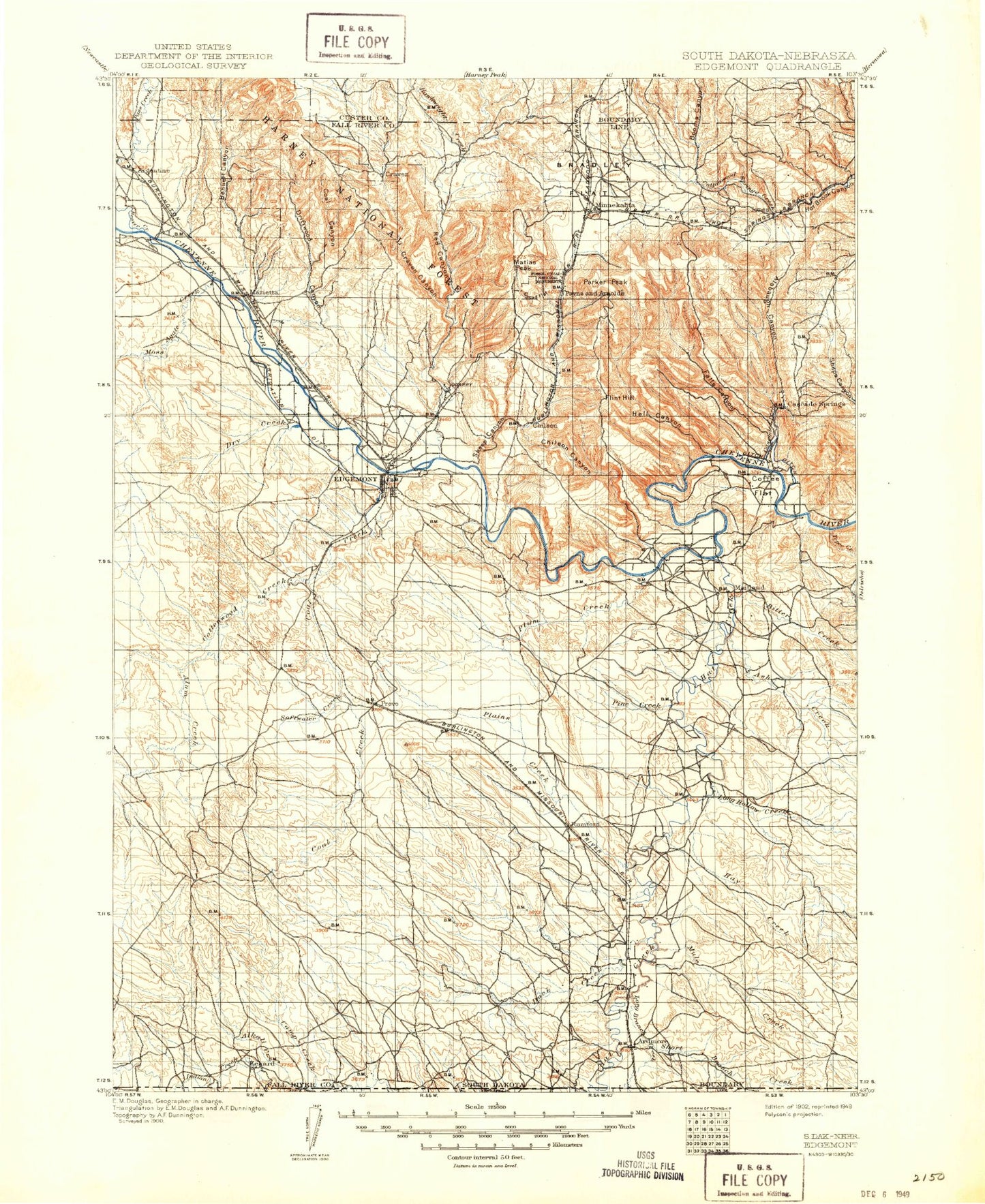
Historic 1902 Edgemont South Dakota 30'x30' Topo Map
Couldn't load pickup availability
Historical USGS topographic map of Edgemontin the states of South Dakota, Nebraska, Wyoming. Scale: 1:125000. Print size: 17" x 24"
This map was published in 1902 and is in the following counties: Custer, Dawes, Fall River, Sioux.
The map contains contour lines, roads, rivers, towns, streams, and lakes. Printed on high-quality waterproof paper with UV fade-resistant inks.
Contains the following named places: Hat Creek, Hay Creek, Argyle Canyon, Alabaugh Canyon, Alum Creek, Ardmore, Ash Creek, Beaver Creek, Bennett Canyon, Bitter Creek, Booms Canyon, Bradley Flats, Brady Canyon, Breakneck Hill, Buck Canyon, Burlington Dam, Camp Creek, Cascade Creek, Cascade Falls, Cedar Canyon, Chilson Canyon, Coal Canyon, Coal Creek, Coffee Creek, Coffee Flat, Conboys Ranch, Cottonwood Creek, Cottonwood Springs Creek, Craven Canyon, Deadhorse Canyon, Dick Canyon, Doran Ranch, Driftwood Canyon, Driftwood Creek, Duck Creek, Dudley, East Bennett Canyon, East Fork Hawkwright Creek, Falls Canyon, Fay Ranch, Fiddle Creek, Flagpole Mountain, Flint Hill, Fossil Cycad National Monument, Griffis Canal, Gull Ranch, Hat Creek, Hawkwright Creek, Hay Creek, Hay Ranch, Hell Canyon, Heppner, Horse Creek, Horse Trap Mountain, Horseshoe Bend, Igloo, Jackson Narrows, Johnson Ranch, Johnson Ranch, Landers Ranch, Lindsley Canyon, Line Camp, Little Cottonwood Creek, Little Tepee Creek, Long Branch Creek, Long Hollow Creek, Marietta, Marty Ranch, Matias Peak, Middle Canyon, Mike Canyon, Miller Cabin, Minnekahta, Moss Agate Creek, Mule Creek, Parker Peak, Payne Canyon, Piney Creek, Plains Creek, Plains Valley, Plum Creek, Provo, Red Canyon, Red Canyon Creek, Red Gulch, Robinson Flats, Robinson Ranch, Rocky Ford, Roundtop Hill, Rumford, Sheep Canyon, Short Branch Creek, Sorghum Flat, Hat Creek Flat, Stage Hill, Stone Quarry Canyon, Tepee Creek, Tubbs Dam, West Fork Hawkwright Creek, Whaley Canyon, White Draw, Wildcat Canyon, Z R Ranch, Mule Creek Dam, Long Hollow Dam, Fishko Dam, Henry Dam, J Chlecq Dam, Dry Draw Dam, Wasserburger Pond Dam, Soske Dam, Fishko Dam Number 2, Fishko Dam Number 3, Cottonwood Springs Dam, Porter Cottonwood Dam, Tubbs Moss Agate Dam, Porter Moss Agate Dam, Double Dam, Bomb Range Dam, Trotter Ranch Dam, Caylor Ranch Dam, Henderson House Dam, Helsels Plum Creek Dam, The Heppner Dam, Duck Creek Dam Number 2, Bhif Dam, Cold Creek Dam, Camp Creek Dam, Indian Dam Number 1, Wasserburger Pond, Chilson Mountain, Devil Canyon, J H Keith Memorial Picnic Area, Wolf Canyon, Cottonwood Springs Lake, Cascade Springs, Chilson Station, Erskine, Bell Ranch, Burdock, Fall River County, Middle Fork Alkali Creek, Middle Fork Duck Creek, Trotter Ranch, Henderson Ranch, Phister Ranch, Barkley Ranch, Wallace Ranch, Eckard, Hunter Hill, Crowe Dam, South Long Hollow Creek, Lightning Draw, Hay Draw, Buck Draw, Black Gulch, Crow Creek, South Fork Alkali Creek, North Fork Duck Creek, North Fork Alkali Creek, Cow Creek, Alkali Creek, Dennis, Dry Creek, Edgemont, Tubbs Canal, Fiddle Creek Dam, Fiddle Creek Reservoir, Softwater Creek, Fossil Point Picnic Area, City of Edgemont, Unorganized Territory of Southwest Fall River, Township of Indian, Township of Craven, Township of Cottonwood, Township of Dudley, Township of Hat Creek, Township of Plain, Township of Provo, Township of Wheeler, Township of Moss Agate, Township of Hot Springs, Township of Argentine, Hat Creek, Horse Creek, Hay Creek, Hat Creek, Long Branch Creek, Beaver Creek, Coffee Creek, Cottonwood Creek, Little Cottonwood Creek