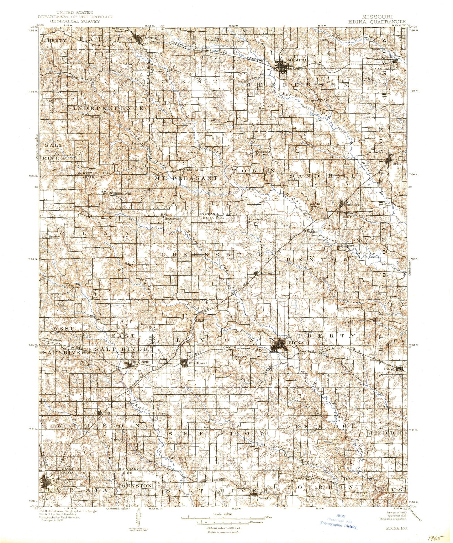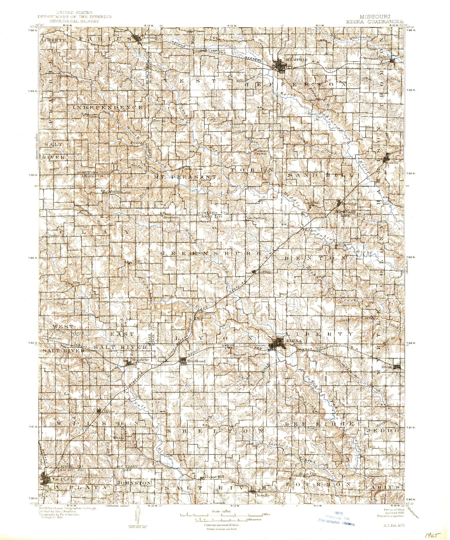
MyTopo
Historic 1903 Edina Missouri 30'x30' Topo Map
Couldn't load pickup availability
Historical USGS topographic map of Edinain the states of Missouri, Iowa. Scale: 1:125000. Print size: 17" x 24"
This map was published in 1903 and is in the following counties: Adair, Knox, Macon, Schuyler, Scotland.
The map contains contour lines, roads, rivers, towns, streams, and lakes. Printed on high-quality waterproof paper with UV fade-resistant inks.
Contains the following named places: Adair, Baring, Bee Branch, Bee Branch, Bible Grove, Brashear, Bridge Creek, Bridge Creek, Brushy Creek, Brushy Fork, Coon Creek, Coon Creek Roadside Park, Cottonwood Fork, Edina, Floyd Creek, Gibbs, Gorin, Gunns Branch, Hickory Branch, Hog Branch, Hurdland, Indian Creek, Long Branch, Long Branch, Long Branch, Long Branch, Lost Creek, Memphis, Memphis Reservoir, Muddy Fork, Nick Branch, North Fork Middle Fabius River, North Fork North Fabius River, North Fork South Fabius River, Norwegian Creek, Novelty, Pony Creek, Rock Creek, Rutledge, Sand Hill Branch, Shelton Branch, South Fork Middle Fabius River, South Fork South Fabius River, Spencer Draw, Spillman Mound, Steer Creek, Surratt Creek, Tauaninny Branch, Timber Branch, Tipp Creek, Titus Creek, Tobin Creek, Wildcat Creek, Willmathsville, Willow Branch, Wolf Branch, Nauvoo, The Lords Bottom, Energy, Middle Fabius, Edinburg, Meadow Brook, Milltown, Buttermilk, Muddy Fork, Pleasant Run, Bee Ridge, Clifton, Paultown, Wilson, Prairie Bird, Arbela, Big Deer Branch, Cottey Creek, Democrat Creek, Downing, Greensburg, Knox City, Plum Branch, Germania, La Plata, Unity, Pleasant Retreat, Hurdland Station, Bullion, Clay, Crawford, Fabius, Hedge City, Kenwood, Locust Hill, Millport, Sand Hill, Edina Golf Club, Memphis Country Club, Edina Reservoir, Hurdland Severs Lake, Santa Fe Lake, Sperry, Knox County, Scotland County, Baring Country Club Dam, Baring Country Club Lake, Kerr Dam, Kerrs Pond, Edina Reservoir Section 7 Dam, Edina Reservoir Section 7, Edina Reservoir Section 12 Dam, James Lake Dam, James Lake, Santa Fe Lake Dam, Hurdland Severs Lake Dam, Memphis Reservoir Dam, Memphis Lake and Park Dam, Memphis Lake, Bear Creek Watershed Dam A-2, A-2 Lake, Sever Lake North Dam, Sever Lake North, Bear Creek Watershed Dam C-23, Ella Ewing Reservoir, Laplata Lake Dam, La Plata Lake, Ivan Starbuck Dam, Starbuck Lake, Number 76 Dam, Miller Lake Dam, Miller Lake, Shultz Lake Dam, Shultz Lake, Taylor Dam, Taylor Lake, Gaylen Hill Dam, McCulough Dam, Patten Lake, Walter R Tompson Dam, Miller and Sons Lake Dam, Wilson Lake Dam, Wilson Lake, Bear Creek Watershed B-26 Dam, West Lake Dam, Greenly Farm Lake Dam, Greenly Farm Lake, Gelbach Farms Lake Dam, Gelbach Farms Lake, Wamsley Lake Dam, Wamsley Lake, Douglas Lake Dam, Douglas Lake, Meyers Lake Dam, Jack Blessing Lake Dam, Jake Blessing Lake Section 12 Dam, Jake Blessing Lake Section 8 Dam, Swearingen Lake Dam, Rowland-Klopfenstein Lake Dam, Rowland-Klopfenstein Lake, Taylor Lake Dam, Taylor Lake, Rock Creek Branch Dam, Colonial Knoll Lake, Parsons Lake Dam, Parsons Lake, Kelley Lake Dam, Brown Lake Dam, Thomas Lake Dam, Wood Lake Dam, Coy Lake Dam, Pickens Lake Dam, La Plata City Reservoir East Dam, Township of Clay, Township of Salt River, Township of Wilson, Township of Bee Ridge, Township of Benton, Township of Center, Township of Colony, Township of Greensburg, Township of Jeddo, Township of Liberty, Township of Lyon, Township of Myrtle, Township of Shelton, Township of Independence, Township of Harrison, Township of Jefferson, Township of Mount Pleasant, Township of Sand Hill, Township of Thomson, Township of Tobin, Township of Vest, City of Brashear, City of Baring, City of Hurdland, City of Downing, City of Edina, City of Memphis, City of Knox City, City of La Plata, Town of Rutledge, Town of Arbela, Town of South Gorin, Village of Gibbs, Village of Novelty, La Plata City Lake, North Fork North Fabius River