MyTopo
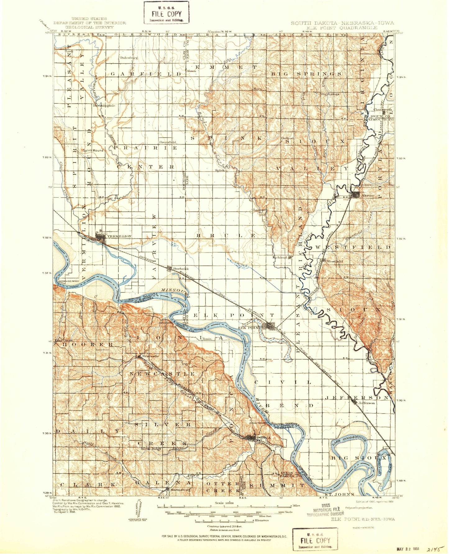
Historic 1907 Elk Point South Dakota 30'x30' Topo Map
Couldn't load pickup availability
Historical USGS topographic map of Elk Pointin the states of South Dakota, Iowa, Nebraska. Scale: 1:125000. Print size: 17" x 24"
This map was published in 1907 and is in the following counties: Clay, Dakota, Dixon, Plymouth, Sioux, Union.
The map contains contour lines, roads, rivers, towns, streams, and lakes. Printed on high-quality waterproof paper with UV fade-resistant inks.
Contains the following named places: Big Ditch, Brule Creek, Burbank Lake, East Brule Creek, East Union Creek, Elk Point, Government Slough, Green Creek, Horseshoe Lake, Hub City, Jefferson, McCook Lake, Mud Lake, Lake Nixon, Nora, Park Jefferson Racetrack, Prentis Park, Richland, Richland Creek, Rose Lake, Sayles Creek, Scott Creek, Sodrac Park, Spink, Union County State Park, Union Creek, Vermillion, West Brule Creek, West Union Creek, McCook Lake, Alsen, Big Springs, Emmet, Greenfield, Hill Side, Junction City, Lodi, Midway, Bloomingdale, McKays Trailer Court, Hoffmans Trailer Court, Clay Point, McCook Lake, Baptist Creek, Burbank, Cabbage Flat, Dalesburg, Lake Goodenough, Spirit Mound, Vermillion River, Union County, Clay County, City of Elk Point, City of Jefferson, Unorganized Territory of Richland, City of Vermillion, Township of Pleasant Valley, Township of Bix Sioux, Township of Jefferson, Township of Civil Bend, Township of Brule, Township of Big Springs, Township of Spink, Township of Emmet, Township of Sioux Valley, Township of Elk Point, Township of Prairie Center, Township of Vermillion, Township of Spirit Mound, Township of Garfield, Township of Big Sioux, Township of Fairview, Spirit Mound Creek, DakotaDome, Nygaard Field, Clay County Waterfowl Production Area, Union County Waterfowl Production Area, Akron, Beaver Creek, Big Sioux County Park, Broken Kettle Creek, Chatsworth, Indian Creek, Joy Creek, Rock Creek, Westfield, Westfield Creek, Sixmile Creek, Broken Kettle, Township of Portland, Township of Sioux, Township of Westfield, Highway Twelve Rest Area, Chatsworth, Silver Maple County Park, Five Ridge Prairie State Preserve, Deer Creek Wildlife Management Area, Westfield, Farmers Co-operative Elevator, Akron Country Club, Akron, Millsite Access, City of Chatsworth, City of Akron, City of Westfield, Horseshoe Lake, Ames Creek, Aowa Creek, Badger Creek, Lime Creek, Boy Scout Hill, Daily Branch, Deer Creek, East Creek, Gibbs Creek, Indian Hill, Lookout Hill, Martinsburg, Maskell, Newcastle, Ponca, Ponca State Park, Powder Creek, Pumpkin Hill, Rattlesnake Hill, Sand Creek, Silver Creek, Turkey Creek, Volcano Hill, Walnut Creek, South Creek, Lembke Landing, Lime Grove, Township of Daily, Township of Hooker, Township of Newcastle, City of Ponca, Township of Ponca, Township of Silvercreek, Aowa Creek Dam 12-8, Aowa Creek Reservoir 12-8, Aowa Creek Dam 31-1, Aowa Creek Reservoir 31-1, Aowa Creek Dam 1-2, Aowa Creek Reservoir 1-2, Aowa Creek Dam 61-3, Aowa Creek Reservoir 61-3, Heald Dam, Heald Reservoir, Schulke Dam, Schulke Reservoir, Curry Dam, Powder Creek Dam 32-9, Powder Creek Reservoir 32-9, Powder Creek Dam 32-13, Powder Creek Reservoir 32-13, Aowa Creek Dam 62-5A, Aowa Creek Reservoir 62-5A, Aowa Creek Dam 61-11A, Aowa Creek Reservoir 61-11A, Aowa Creek Dam 63-1A, Aowa Creek Reservoir 63-1A, Aowa Creek Dam 6-7a, Aowa Creek Reservoir 6-7A, Aowa Creek Dam 32-4a, Aowa Creek Reservoir 32-4A, Mattison Park, Buckskin Hills State Wildlife Management Area, Buckskin Hills Lake, Mulberry Bend State Wildlife Management Area, Ponca State Park Trails, Ponca State Park Three State Overlook, Ponca Rodeo Arena, Highland Oaks Golf Course, Ponca State Park Historical Marker, Ponca Historical Marker, Lewis and Clark Camp Sites: August 23 24 and 25 1804 Historical Marker, Ionia 'Volcano' Historical Marker, Pfister Park, Village of Martinsburg, Village of Maskell, Village of Newcastle