MyTopo
Historic 1940 Elk Ridge Utah 30'x30' Topo Map
Couldn't load pickup availability
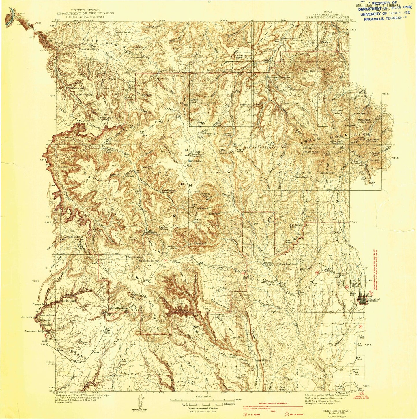
Historical USGS topographic map of Elk Ridgein the states of Utah, Colorado. Scale: 1:125000. Print size: 20" x 24"
This map was published in 1940 and is in the following counties: San Juan.
The map contains contour lines, roads, rivers, towns, streams, and lakes. Printed on high-quality waterproof paper with UV fade-resistant inks.
Contains the following named places: Cottonwood Canyon, Pinon Point, Sweet Alice Canyon, Beef Basin, Beef Basin Wash, Black Mesa Butte, Bull Canyon, Calf Canyon, Cherry Canyon, Dog Tanks Draw, Hotel Rock, House Park, House Park Butte, Lower Lost Parks, Perkins Ranch, South Canyon, The Heel, The Hideout, The Toe, Trail Canyon, Upper Lost Parks, West Mountain, Wild Cow Point, Woodenshoe Buttes, Zekes Hole, Middle Park, Butler Wash Viewpoint, Delicate Arch Trail, Ford Mine Shaft, Natural Bridge, Davis Pocket, Abajo Mountains, Allen Canyon, Arch Canyon, Aspen Flat, Babylon Pasture, Bayles Ranch, Bears Ears, Big Canyon, Big Pocket, Black Steer Knoll, Blue Creek, Bob Park Peak, Boundary Butte, Bridger Jack, Bridger Jack Mesa, Bright Angel Trail, Brushy Basin Wash, Brushy Knoll, Burch Canyon, Butts Canyon, Cathedral Butte, Chimney Park, Chippean Canyon, Chippean Ridge, Chippean Rocks, Cooper Reservoir, Cream Pots, Davis Canyon, Deadman Canyon, Deadman Point, Deep Canyon, Drift Trail Canyon, Dry Wash, Duck Lake, Duckett Cabin, Dwarf, East Fork Salt Creek, East Point, Fable Valley, Gooseberry Ranger Station, Grand Flat, Hammond Canyon, Harmony Flat, Hells Half Acre, Hop Creek, Horse Flat, Horse Mountain, Horse Pasture Canyon, Indian Creek Ranger Station, Indian Park, Indian Village, Kane Gulch, Kelly Ranch, Kigalia Canyon, Kigalia Point, Kigalia Ranger Station, Mount Linnaeus, Little Baullie Mesa, Little Dry Mesa, Little Notch, Lyman Canyon, Mancos Jim Butte, Maverick Point, Maverick Point, Milk Ranch Point, Mormon Flat, Mormon Pasture, Mormon Pasture Point, Mule Canyon, North Fork Mule Canyon, North Fork Whiskers Draw, Notch Canyon, Peavine Canyon, Poison Canyon, Posey Canyon, Red Bluffs, Red Ledges, Reservoir Canyon, Rig Canyon, Robertson Pasture, Round Mountain, Ruin Canyon, Salt Creek Mesa, Seven Sisters Buttes, Shay Mesa, Shay Mountain, Shay Ridge, Short Point, South Fork Fish Creek, South Long Point, Sphinx Rock, Starvation Point, Steamboat Point, Step Point, Stevens Canyon, Sweet Alice Hills, Texas Canyon, Texas Flat, The Causeway, The Notch, The Wilderness, Trail Canyon, Trough Canyon, Tuerto Canyon, Vega Creek, Warren Canyon, Westwater Creek, Whiskers Draw, Wilson Ranch, Dry Wash Number Two Reservoir, Dry Wash Number Two Dam, Spring Lake, Spring Lake Dam, San Juan County, Angel Arch, Arch Canyon Overlook, Baullies, Blue Creek Point, Butts Point, Cathedral Arch, Cathedral Point, Cave Towers, Cyclone Flat, Dry Basin, Fortress Canyon, Kane Gulch Ranger Station, Kane Gulch Trailhead, Keystone Arch, Kirk Cabin, Lavender Point, Monument Valley Overlook, Mormon Pasture Mountain, Mud Canyon, Natural Bridge, Natural Bridges National Monument Campground, Natural Bridges National Monument Visitor Center, Newspaper Rock Campground, Salvation Knoll, Sego Flat, Squaw Water Hole, Stimper Arch, Queens Arch, Poso Pasture, Steamboat Point Mine, Redd Pasture, Wabin Mine, Ute Cabin, Arch Canyon Overlook, Blue Creek Reservoir, Cliff Dwellers Pasture, Cys Monument Mine, Grand Gulch Ranger Station, Dry Wash Reservoir, Maverick Visitor Information Site, Black Bean Mine, Avalanche Mine, Betty Mine, Newspaper Rock, Arch Canyon Trail, Peavine Trail, Hole in the Rock Trail, Bear Creek, Cheese and Raisins Hills, Chimney Park, Cleft Arch, Kirk Arch, Newspaper Rock State Historical Monument, Reef of Rocks, Wedding Ring Arch, Grand Gulch Plateau, Bayles Cabin, Manti-La Sal National Forest - La Sal Division, Red Bluff Campground, Scorup Cabin Point of Interest, Natural Arch Point of Interest, North Long Point, Duck Lake Point of Interest, Hammond Canyon Point of Interest, Bears Ears Point of Interest, Skull and Crossbones Point of Interest, Natural Bridges Recreation Site, Maverick Point Overlook, North Cottonwood Guard Station, Natural Arch Point of Interest, South Elk Ridge, North Elk Ridge, Photovoltaic Array, The Hideout, Blue Creek Cabin, Brushy Basin, Cherry Creek, Duckett Ridge, Skull and Crossbones Summit, Aesops Arch, Cottonwood Creek, Blanding Division, Dark Canyon Wilderness, City of Blanding, Bears Ears National Monument, Dry Mesa, Tse Nizh'oni-Stellar Arch, Manti-La Sal National Forest - La Sal Division