MyTopo
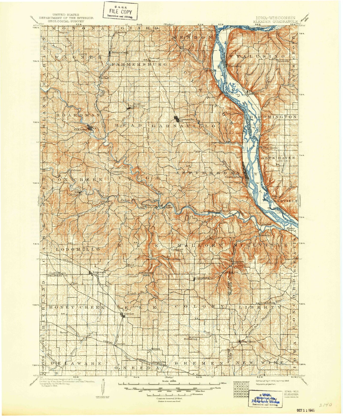
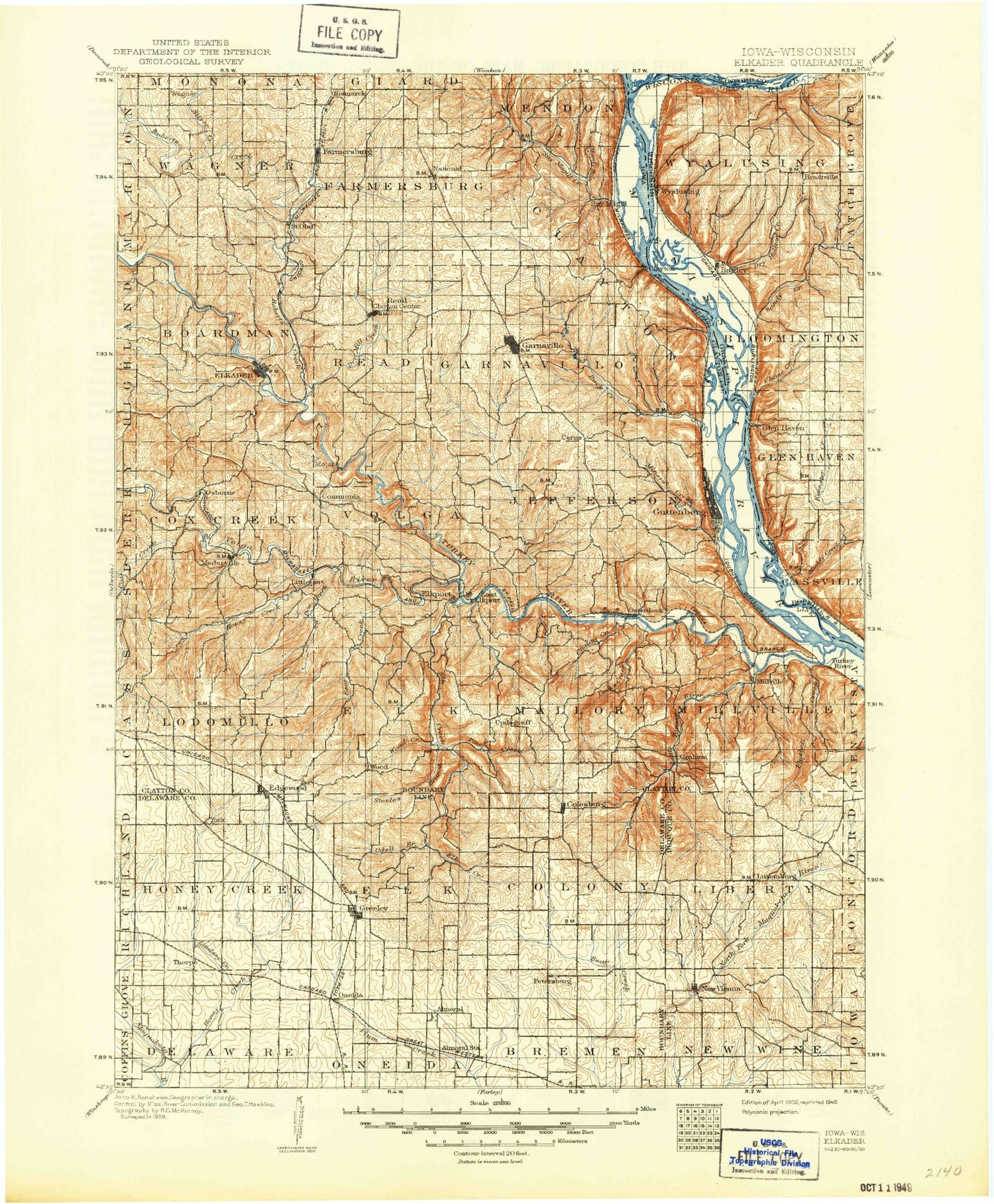
Historic 1902 Elkader Iowa 30'x30' Topo Map
Couldn't load pickup availability
Historical USGS topographic map of Elkader in the state of Iowa. Scale: 1:125000. Print size: 18" x 24"
This map was published in 1902 and is in the following counties: Clayton, Crawford, Delaware, Dubuque, Grant.
The map contains contour lines, roads, rivers, towns, streams, and lakes. Printed on high-quality waterproof paper with UV fade-resistant inks.
Contains the following named places: Ackerman Cut, Adams Mill Hollow, Alderson Hollow, Almoral Branch, Andregg Hollow, Andy Hollow, Bear Creek, Beddows Hollow, Big Pond, Bixby State Park, Bloody Run, Bluebell Creek, Brownfield Creek, Buck Creek, Butternut Hollow, Carlan Creek, Cassville Iowa Slough, Cassville Slough, Cherry Valley, Chicken Ridge, Clayton, Clayton Center, Coffee Creek, Colesburg, Coon Creek, Cow Branch, Cox Creek, Devils Hollow, Doe Creek, Dry Hollow, Dry Mill Creek, Edgewood, Elk Creek, Elkader, Elkport, Ellis Park, Fairview, Farmersburg, Ferry Slough, Fountain Springs Creek, French Hollow, French Island, Frenchtown Lake, Frieden Park, Garber, Garnavillo, Goetz Island, Greeley, Guttenberg, Hickory Creek, Hog Hollow, Holbert Park, Honey Creek, Honey Creek, Hovie Island, Howard Creek, Island 176, Island 178, Island 186, Island 188, Island 189, Johnsons Slough, Johles Creek, Kleinlein Creek, Kline Hunt Hollow, Lindsey Creek, Little Turkey River, Littleport, Lock and Dam No, Louse Hollow, Luxemburg, McMillan Island, Mederville, Mill Creek, Millville, Miners Creek, Moody Run, Mossy Glen Hollow, National, New Vienna, North Cedar Creek, Odell Branch, Oneida, Osterdock, Panther Creek, Peck Creek, Petersburg, Petersburg Station, Pikes Peak State Park, Pine Creek, Pine Hollow, Point Hollow, Price Branch, Quaker Mill Pond, Rabbit Creek, Ram Hollow, Red Schoolhouse, Rieger Creek, Roberts Creek, Rock Hollow, Routherford Branch, Saint Olaf, Schechtman Branch, Silver Creek, Sny Magill Creek, South Cedar Creek, Spring Lake, Steeles Branch, Swift Slough, Thorpe, Tuecke Hollow, Turkey River, Turkey River, Turkey River Mounds State Monument, Updegraff, Volga River, Wayman Creek, West Branch South Cedar Creek, White Pine Hollow, White Pine Hollow State Park, Wolf Creek, Wood, Wyalusing Slough, Lock and Dam 10, Clayton County Fairgrounds, Springville, Jefferson, Bismark Station, Saint Patrick Station, Eckards, Snefs, Millville Siding, York, Holy Cross, Almoral, Bente Branch, Ceres, Communia, Dutchtown, Motor, Osborne, Spring Branch, Clayton County, Wagner, Garretts Branch, Township of Boardman, Township of Bremen, Township of Clayton, Township of Colony, Township of Cox Creek, Township of Delaware, Township of Elk, Township of Elk, Township of Farmersburg, Township of Garnavillo, Township of Honey Creek, Township of Jefferson, Township of Liberty, Township of Lodomillo, Township of Mallory, Township of Millville, Township of New Wine, Township of Oneida, Township of Read, Township of Volga, Township of Wagner, Cassville Slough, Merritt Forest State Preserve, Turkey River Mounds State Preserve, Rentz Memorial Woods State Preserve, Osterdock Bridge Access, Garber Bridge Access, Motor Mill Access, Mossy Glen State Preserve, Stone's Plantation, Cox Creek Rest Area, Chicken Ridge Scenic Overlook Park, Mederville Access, Lovers Leap Park, Ardell Kader City Park, French Town Lake Access, Buck Creek Area Park, Roberts Creek State Preserve, Sny Magill North Cedar Creek Wildlife Management Area, Great River Road Trail, Pony Hollow Trail, Clayton, Saint Olaf Feed and Supply Incorporated Elevator, Guttenberg, Guttenberg Golf and Country Club, Iowa State Fish Aquarium and Hatchery, Guttenberg City Park, Paradise Valley Campground, J-Wood Camp Grounds, Garnavillo City Park, Osborne Conservation Center, Big Spring Trout Hatchery, Elkader Golf and Country Club, Turkey River Park, Riverside Park, Woods Edge Golf Course, Elkader City Park, Table Rock Site of July 4 1838 Celebration Historical Marker, Old Stone Schoolhouse Historical Marker, Peter Holms Historical Marker, Hart Ridge Golf Course, Seibert Park, Fountain Springs Park, Lone Pine Golf Course, Ram Hollow - Hoffman Wildlife Area, Twin Bridges Park, Lloyd Kelchen Grain Elevator, New Wine Park, Colesburg Roadside Park, City of Clayton, City of Colesburg, City of Guttenberg, City of Edgewood, City of Elkader, City of Elkport, City of Farmersburg, City of Garber, City of Garnavillo, City of Greeley, City of New Vienna, City of Luxemburg, City of Osterdock, City of Saint Olaf, Adams Dairy, Am Dar Farm, Johles Hollow, Norwegian Lake, Methodist Lake, Goose Pond, Bussey Lake, Guttenberg Ponds Sanctuary