
MyTopo
Historic 1894 Ellsworth Kansas 30'x30' Topo Map
Couldn't load pickup availability
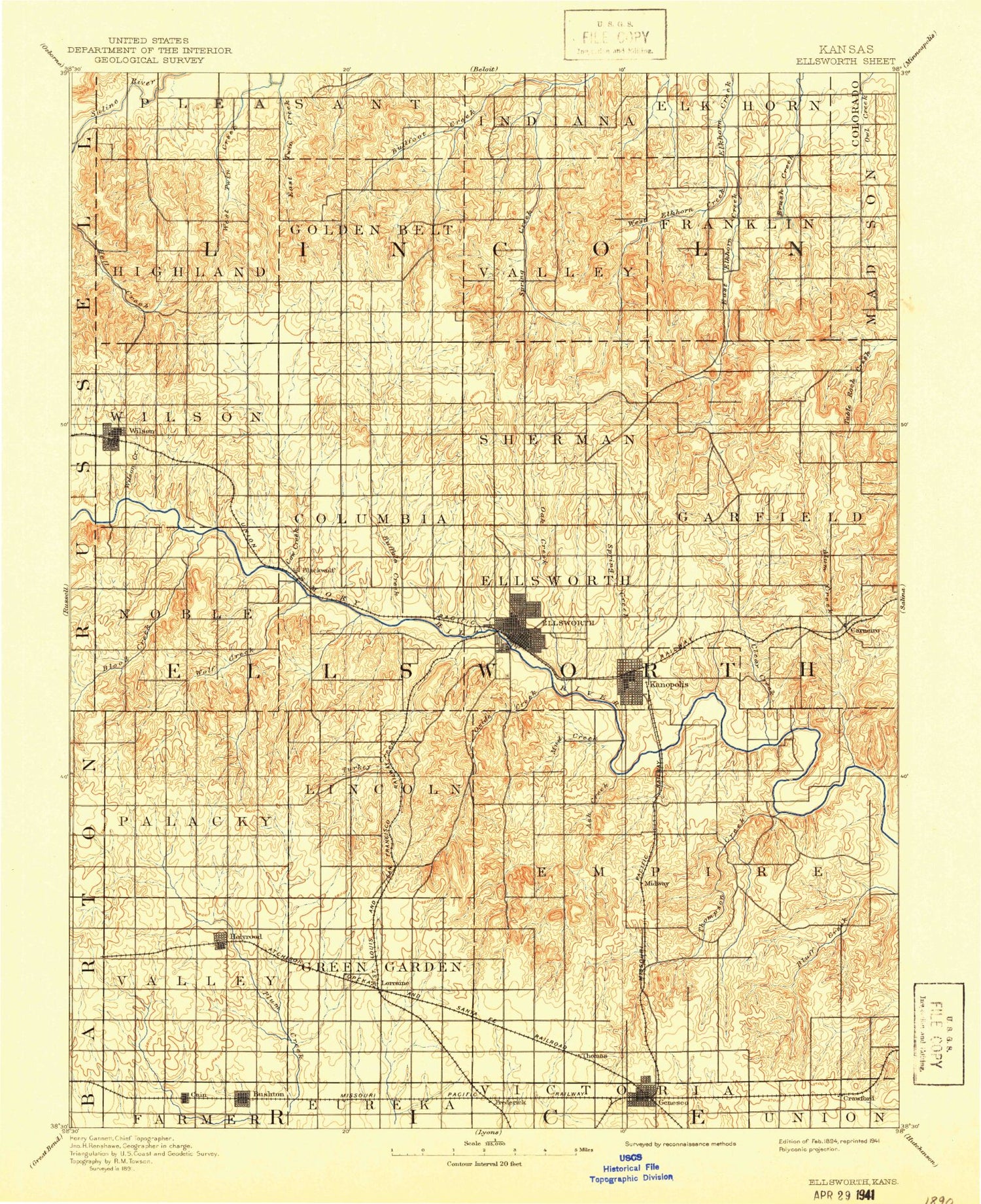
Historical USGS topographic map of Ellsworth in the state of Kansas. Scale: 1:125000. Print size: 17" x 24"
This map was published in 1894 and is in the following counties: Barton, Ellsworth, Lincoln, Rice, Russell.
The map contains contour lines, roads, rivers, towns, streams, and lakes. Printed on high-quality waterproof paper with UV fade-resistant inks.
Contains the following named places: Wilson Dam, Highland Lake, West Twin Creek, Township of Highland, Township of Golden Belt, East Twin Creek, Buffalo Creek, Cow Creek, Township of Valley, Township of Franklin, Spring Creek, West Elkhorn Creek, East Elkhorn Creek, Westfall, Coal Creek, Wilson, Township of Noble, Wilson Creek, Township of Wilson, Spring Creek, Blood Creek, Black Wolf, Township of Columbia, Township of Sherman, Township of Black Wolf, Township of Ellsworth, Oak Creek, Township of Garfield, West Oak Creek, East Oak Creek, Spring Creek, East Spring Creek, Township of Clear Creek, Clear Creek, Alum Creek, Township of Palacky, Progress Oil Field, Stoltenberg Oil Field, Wolf Creek, Loss Creek, Progress Northwest Oil Field, Holyrood Lake, Township of Ash Creek, Township of Lincoln, Oxide Creek, Turkey Creek, Little Wolf Creek, Ellsworth, Kanopolis, Mud Creek, Ash Creek, Skunk Creek, Township of Empire, Thompson Creek, Yankee Run, Carneiro, Bushton, Heinz Oil Field, Bloomer Oil Field, Heiken North Oil Field, West Oil Field, Kraft-Prusa Northeast Oil Field, Roesler Oil Field, Township of Valley, Holyrood, Heiken Oil Field, Township of Green Garden, Lorraine, Frederick, Bredfeldt Oil Field, Prosper East Oil Field, Lorraine Oil Field, Lorraine North Oil Field, Green Garden Oil Field, Township of Thomas, Township of Trivoli, Geneseo, Maes Oil Field, Andrews Oil Field, Geneseo-Edwards Oil Field, Click Southeast Oil Field, Bluff Creek, Ellsworth County Dam, Highland Dam, Yankee Run Point Public Use Area, Boldt Bluff Public Use Area, Otoe Public Use Area, Sylvan Public Use Area, Wilson State Wildlife Area, Margaret, Cain, Bens Branch, Edalgo, Farhman, Midway, Crawford, Barton, Ellsworth County, City of Ellsworth, City of Bushton, City of Holyrood, City of Frederick, City of Geneseo, City of Kanopolis, City of Lorraine, City of Wilson, Wilson State Park Otoe Boat Ramp, Wilson State Park Coneflower Campground, Wilson State Park Dropseed Campground, Wilson State Park Goldenrod Campground, Wilson State Park Indiangrass Campground, Wilson State Park Sagewort Campground, Wilson State Park Sunflower Campground, Wilson State Park Yarrow Campground, Wilson State Park Yucca Campground, Wilson State Park Marina, Ellsworth Wastewater Plant, Wilson Wastewater Plant 2, Holyrood Wastewater Plant, Geneseo Wastewater Treatment Facility, Bushton Wastewater Treatment Plant, Ellsworth County C and D Landfill, Smoky Hills Wind Farm, Kansas Department of Transportation Ellsworth County Rest Area, Kanopolis Wastewater Plant, Lorraine Wastewater Treatment Facility, Kanopolis State Park Eagle Point Campground, Rockin' K Horse Campground at Kanapolis State Park, Claflin Golf Club, Ellsworth Golf Course, Geneseo Golf Club, El - Kan Western Riders Rodeo Arena, Agmark Grain Elevator Number 20, Ellsworth Co - Operative Grain Elevator Number 1, Ellsworth Co - Operative Grain Elevator Number 2, Ellsworth Co - Operative Grain Elevator Number 3, Ellsworth Co - Operative Grain Elevator Number 5, Ellsworth Co - Operative Grain Elevator Number 6


