MyTopo
Historic 1894 Emporia Kansas 30'x30' Topo Map
Couldn't load pickup availability
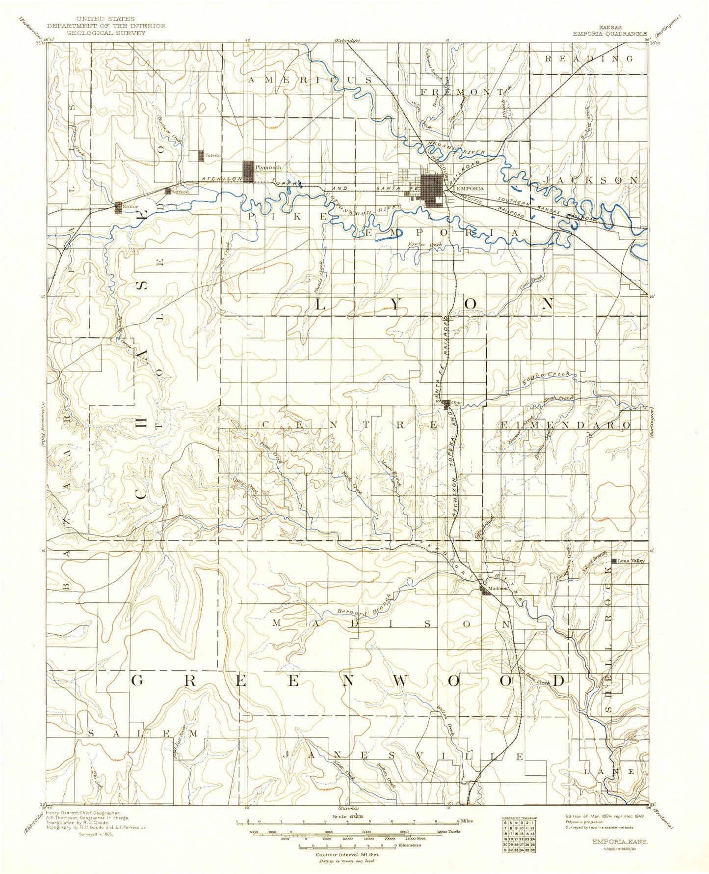
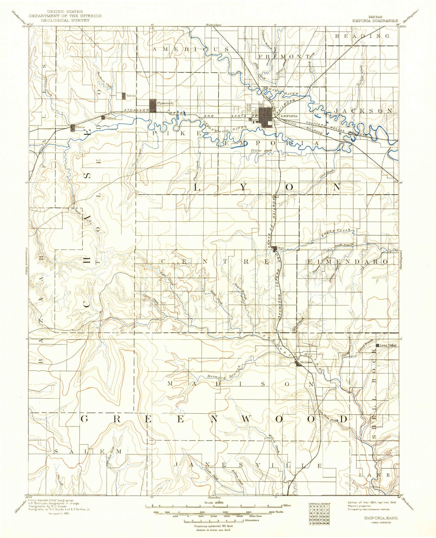
Historical USGS topographic map of Emporia in the state of Kansas. Scale: 1:125000. Print size: 17" x 24"
This map was published in 1894 and is in the following counties: Chase, Greenwood, Lyon.
The map contains contour lines, roads, rivers, towns, streams, and lakes. Printed on high-quality waterproof paper with UV fade-resistant inks.
Contains the following named places: Township of Salem, Allen Creek, Dow Creek, Township of Toledo, Troublesome Creek, Pester Creek, Stillman Creek, Badger Creek, Taylor Creek, Peyton Creek, Bull Creek, Saffordville, Stout Run, Jacob Creek, Beaver Creek, Phenis Creek, Plymouth, Toledo, Linck Creek, Ludy Creek, Moon Creek, Bloody Creek, Little Bloody Creek, Norton Creek, South Fork Cottonwood River, Spring Creek, Rock Creek, Shaw Creek, Olpe, Olpe City Lake, Dry Creek, Township of Center, Hoosier Creek, Harper Creek, South Eagle Creek, Coal Creek, Township of Elmendaro, Buckeye Creek, East Buckeye Creek, Dryer Park, Ruggles Dam, Hammond Park, East Lake, Soden Dam, Peter Pan Park, Soden Park, Emporia Junction, Fremont Park, Humbolt Park, Emporia, Township of Pike, Cottonwood River, Township of Emporia, Plumb Creek, Coon Creek, Dry Creek, Township of Jackson, Bull Creek, Camp Creek, Township of Matfield, Wolf Creek, South Branch Verdigris River, North Branch Verdigris River, Kelly Branch, Madison, Moon Branch, Township of Madison, Tate Branch Creek, Township of Shell Rock, Scott Oil Field, Texaco Hill, Cities Service Lake, Zimmermann Oil Field, Sinclair Lake, Thrall, Burkett Oil Field, Teter Oil Field, Browning Oil Field, Bernard Branch, Indian Creek, Seeley-Wick Oil Field, De Malorie-Sowder Oil Field, Long Creek, Van Horn Creek, Holderman Creek, Lamont, Olpe City Dam, Twelfth Street Village Mall, Mini Plaza, Flinthills Mall, Flint Hills Village, Emporia West Plaza, Jones Youth Recreation Park, Emporia Country Club, Berkeley Hills, Woodland Park, Las Casitas Park, Lowther Field, Southwest Santa Fe Park, Walnut Park, Quaker Park, Wooster Lake, Wilson Park, Lakeview Park, Sertoma Park, Urbanside Park, Industrial Park III, Emporia Municipal Zoo, Halderman Creek, Ellinor, Gladstone, Merrick, Lang, Kenbro, Teterville, Burkett, Hilltop, Bisbee, Lyon County, Madison Golf Course, City of Emporia, Welch Stadium, Zola Witten Track, Kellogg Circle, City of Madison, City of Olpe, Olpe Sewer Treatment Plant, Americus Wastewater Treatment Facility, Kansas Turnpike Authority - Emporia Service Area Oria Service Area, Jones Aquatic Center, Lyon County Fairgrounds, Emporia Wastewater Treatment Plant, Madison Wastewater Treatment Facility, Belmont Mobile Home Estates, Genes Mobile Home Park, Lincoln Mobile Home Village, Paradise Mobile Home Park, Southgate Mobile Home Park, Westhill Mobile Home Park, Emporia Recreational Vehicle Park and Campground, Emporia Municipal Golf Course, EMCH Feed and Elevator Company Grain Elevator Number 1, F and F Feeds Grain Elevator Number 1, Leffler Farms, Anderson Farms, Childears Farm, Fowler Farms, Heins Farm, Fuller Farms, Kitts Farms, Langley Farm, Lazy H Farms, Richardson Farms, Timber Creek Farms, Wagaman Farms, Gloria's Ranch, Haag Farms, Seven Bar Ranch, Gardner Farms, Martin Dairy, Mautz Farm, Wigton Farms, Flint Hills Feedlot, Delong Feedlot