MyTopo
Historic 1895 Fargo North Dakota 30'x30' Topo Map
Couldn't load pickup availability
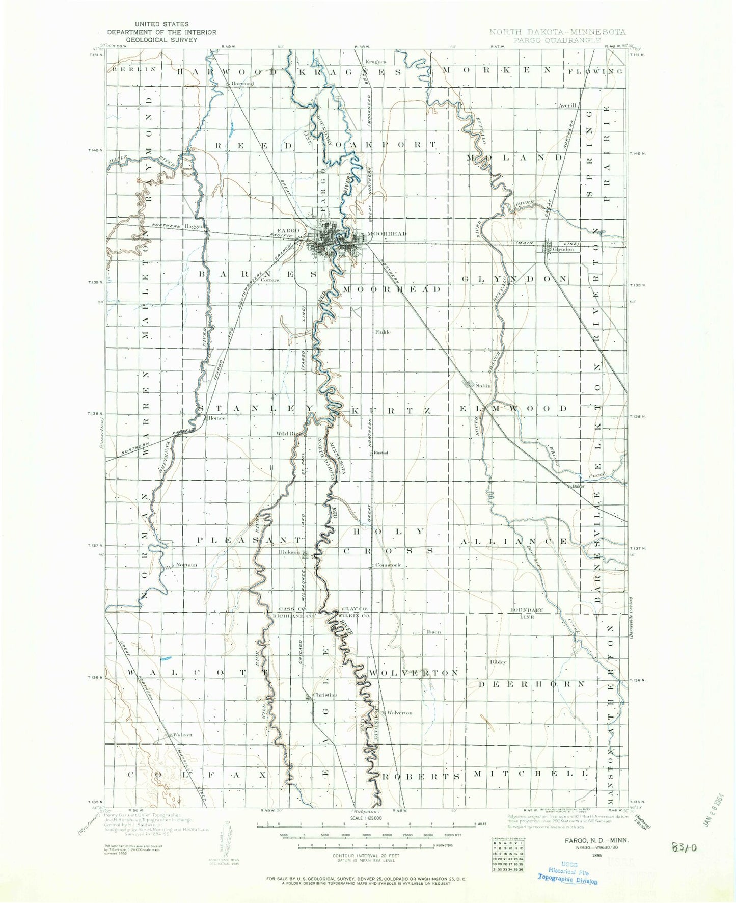
Historical USGS topographic map of Fargoin the states of North Dakota, Minnesota. Scale: 1:125000. Print size: 17" x 24"
This map was published in 1895 and is in the following counties: Cass, Clay, Richland, Wilkin.
The map contains contour lines, roads, rivers, towns, streams, and lakes. Printed on high-quality waterproof paper with UV fade-resistant inks.
Contains the following named places: Christine, Fargo, Harwood, Hickson, Horace, Island Park, Jameson Park, Lindenwood Park, Lower Branch Rush River, Maple River, Mickelson Field, Norman, Oak Grove Park, Percy Godwin Park, Roosevelt Playground, Rush River, Saint Benedict, Walcott, West Fargo, Wild Rice, Fargo 12th Avenue Dam, Fargo Dam 2, Christine Dam, Fargo Dam Number 3, Sheyenne River Diversion Dam, Fargo 4th Street South Dam, Elm Tree Square, Northport Mall, Valley North Mall, Village Square, West Acres Shopping Center, Southside Shopping Center, Market Square, Block Six of the Original Townsite, City of Oxbow, Lithia, Pinkham, Fife, Riverside, Meadow Brook Park, Wild Rice River, South West Fargo, City of Briarwood, City of Christine, City of Fargo, City of Frontier, City of Harwood, City of Horace, City of North River, City of Prairie Rose, City of Reile's Acres, City of Walcott, City of West Fargo, Township of Pleasant, Township of Normanna, Township of Stanley, Township of Barnes, Township of Warren, Township of Mapleton, Township of Reed, Township of Raymond, Township of Colfax, Township of Eagle, Township of Walcott, Reiles Acres, Prairie Rose, North River, Frontier, Briarwood, Fargo Wastewater Treatment Plant, Township of Fargo, Oxbow, Fargo City Landfill, Fargodome, Schlanser Running Track, Newman Outdoor Field, Dacotah Field, Bison Sports Arena, Shelly Ellig Indoor Track and Field Facility, Red River Zoo, Red River Valley Speedway, Averill, Baker, Comstock, Concordia Field, County Ditch Number Eleven, County Ditch Number Twelve, County Ditch Number Thirteen, County Ditch Number Two, County Ditch Number Twentyone, County Ditch Number Twentytwo, County Ditch Number Twentyfive, County Ditch Number Twentysix, County Ditch Number Twentysix, County Ditch Number Three, County Ditch Number Thirtytwo, County Ditch Number Thirtythree, County Ditch Number Thirtyfive, County Ditch Number Thirtyfive, County Ditch Number Thirtysix, County Ditch Number Thirtynine, County Ditch Number Fortyone, County Ditch Number Fortyseven, County Ditch Number Five A, County Ditch Number Fifty, County Ditch Number Fifty, County Ditch Number Fiftythree, County Ditch Number Nine, Deerhorn Creek, Dilworth, Glyndon, Hay Creek, Kragnes, Lamb Park, Matson Field, Moorhead, Nyqist Coulee, Rustad, Sabin, South Branch Buffalo River, Whisky Creek, Wolverton, Wolverton Creek, Wood Lawn Park, Finkle, Stony Creek, Township of Alliance, Township of Deerhorn, Township of Elmwood, Township of Glyndon, Township of Holy Cross, Township of Kurtz, Township of Mitchell, Township of Moland, Township of Moorhead, Township of Oakport, Township of Roberts, Township of Wolverton, Ottertail River Dam, Ottertail River Reservoir, Moorhead Lagoon Dam, Red River Dam, Ganz Dam, Oakport, Wolverton, Tony's Campground, Rustad, Kragnes, Moorhead, Moorhead KOA Campground, Dulsky Mobile Home Court, Greenwood Communities, Saint John's Episcopal Church Historic Marker, Knapp Park, Solomon Gilman Comstock House State Historic Site, Heritage Hjemkomst Interpretive Center, South Park, Moorview Soccer Complex, Ridgewood Park, Village Green Golf Course, Village Green Park, River Oaks Park, Angeles Park, Belsly Park, Riverview Estates Park, Holiday Mall, Horn Park, Daley Park, Townsite Park, Alm Park, Gooseberry Mound Park, Moorhead Sports Center, Romkey Park, Meadows Golf Course, Morningside Park, Clay County Museum, Memorial Park, Riverfront Park, Viking Ship Park, Center Mall, Arrowhead Park, Moorhead Softball Diamonds, Centennial Park, Original Homestead Park, Northeast Park, Bulane Park, Hansmann Park, Moorhead Country Club, Voll Park, MB Johnson Park, Sabin, Buffalo River Speedway, Glyndon Mobile Home Park, Glyndon, Glyndon City Hall, Dilworth, Dilworth Trailer Park, Park Lane Mobile Home Park, Constitution Park, Easten Mall, Walnut Park, Birch Tree Park, Whistle Stop Park, Cottonwood Park, Comstock, Baker, Bonanza Farms in the Red River Valley Historical Marker, Blue Star Memorial Highway Historical Marker, Moorhead Travel Information Center, City of Comstock, City of Dilworth, City of Glyndon, City of Moorhead, City of Sabin, City of Wolverton