MyTopo
Historic 1899 Fayetteville Arkansas 30'x30' Topo Map
Couldn't load pickup availability
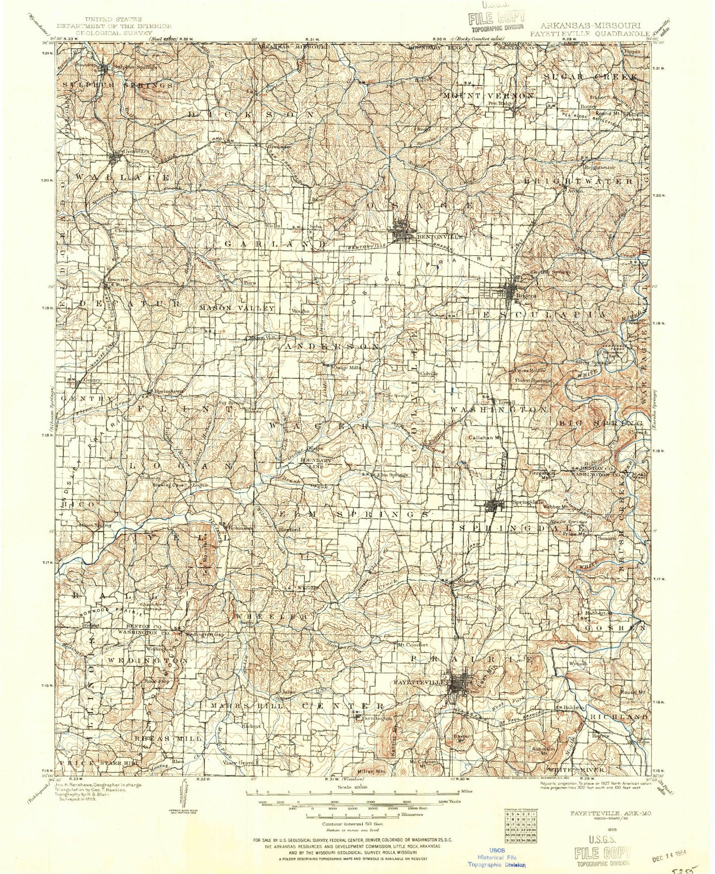
Historical USGS topographic map of Fayetteville in the state of Arkansas. Scale: 1:125000. Print size: 18" x 24"
This map was published in 1899 and is in the following counties: Barry, Benton, McDonald, Washington.
The map contains contour lines, roads, rivers, towns, streams, and lakes. Printed on high-quality waterproof paper with UV fade-resistant inks.
Contains the following named places: Apple Spur Community Center, Avoca, Bear Creek, Bella Vista, Blackburn Creek, Brush Creek, Carden Branch, Cato Springs Branch, Caverna, Cedar Bluff, Corinth Community Hall, Cross Creek, Dream Valley, East Flint Creek, Esculapia Hollow, Falls Hollow, Lake Fayetteville, Friendship Creek, Grape Hollow, Harris, Healing Springs, Helton Bluff, Horse Creek, Horseshoe Bend, Hotz Park, Joe Creek, Kessler Mountain, Liberty Bell Community Center, Little Hickory Creek, Little Wildcat Creek, Martin Bluff, McElhaney Bluff, Mill Branch, Mill Hollow, Mount Comfort, Mountain Home School, Murphy Park, Neills Bluff, Nelson Hollow, North Flint Creek, Pawpaw Hollow, Pea Ridge National Military Park, Phillips Creek, Pinion Hollow, Pumpkin Hollow, Puppy Creek, Railroad Hollow, Richland Creek, Roberts Creek, Rocky Dell Hollow, Rogers, Shady Grove Community Hall, Sonora, Southgate Shopping Center, Spanker Creek, Spring Creek, Steele Community Center, Sugar Hollow, Sycamore Park, Tanyard Creek, Town Branch, Walker Park, Ward Slough, Appleby, Blackjack Corner, Frisco, Seba, Wyman, Baldwin, Beaver Shores, Clear Point, Creech, Goat Hill, Gobblers Knob, Hickory Creek, Highfill, Mason Valley, McCullom Mountain, Miller Mountain, Monte Ne Shores, Mount Sequoyah, Pleasure Heights, Prairie Creek, Price Mountain, Robinson Mountain, Root Hill, Round Mountain, Round Top Mountain, South Mountain, Sulphur Springs, Vaughn, Washington Mountain, Webber Mountain, Asbell Park, Agricultural Park, Archias Mountain, Babe Ruth Ball Park, Beav-O-Rama, Blue Springs Use Area, Blue Springs Village, Bobby Hopper Park, Butterfield Trail Park, Central Plaza, Colonial Village Shopping Center, Combs Park, Crossover Park, Eastgate Shopping Center, Elmdale Shopping Center, Evelyn Hills Shopping Center, Fayetteville Industrial Park, Fiesta Square Shopping Center, Finger Park, George Cole Field, Gregory Park, Happy Hollow Park, Harmon Playground, Harp Mountain, Jefferson Park, Lake Wedington Recreation Area, Millsap Mountain, Mount Nord Historic District, Northwest Arkansas Mall Shopping Center, Oak Plaza Shopping Center, Pierce Mountain, Plaza Shopping Center, Lake Fayetteville Park, Raid Mountain, Razorback Golf Course, Razorback Stadium, Rochelle Riviera, Root Park, Shady Grove, Shiloh Historic District, Shiloh Memorial Park, Southgate Shopping Center, Springdale Country Club, Starks, Sunset Square Shopping Center, Sweetbriar Park, Walker Park, Washington County Fairgrounds, Washington Park, Washington-Willow Historic District, Wedington Woods, Westgate Shopping Center, Wildcat Creek, Wilson Park, Township of Center, Township of Elm Springs, Township of Harmon, Township of Illinois, Township of Johnson, Township of Litteral, Township of Marrs Hill, Township of Prairie, Township of Rheas Mill, Township of Springdale, Township of Tontitown, Township of Wedington, Township of Wyman, Benton County, Brush Creek, Camp Ozark, Clear Creek, Fairmount Community Hall, Farmington Branch, Gallatin, Goose Creek, Hamestring Creek, Lick Branch, Logan, Moores Creek, Owl Creek, Palmer Hollow, Pedro, Robinson, Roundtop, Tontitown, Twin Mountains, Walnut Grove, Weaver Hill, Weddington Gap, Weddington Mountain, West Fork White River, White Rock, Weddington Hiking Trail, Trident, Lake Weddington Campground, Lake Weddington Picnic Area, Crystal Lake, Paradise Valley Golf Course, Accident, Apple Spur, Benton County Fairgrounds, Blackburn Arm, Cash Hollow, Cash Village Shopping Center, Chambers Spring Branch, Decatur Park, Devils Head Bluff, Dillon Shopping Center, Dixieland Mall Shopping Center, Dug Hill, Eagle Corner, Fairmount, Field Kindley Memorial Park, Ford Park, Green Valley Bible Campground, Gum Springs Hollow, Leetown, Lower Round Top, Lake Elmdale, Kinion Lake, Martin, Martin Valley, Midtown Shopping Center, Miller, Monte Ne Valley, Norwood, Oak Grove, Osage Mills Dam, Osage Prairie, Park Spring Park, Pine Creek, Pleasant Hill, Pleasant Ridge, Pleasant Ridge, Rocky Comfort, Seilers Branch, Silent Grove, Spring Branch, Spring Creek, Standing Rock Hollow, Sulphur Springs City Park, Tiger Stadium, Upper Round Top