MyTopo
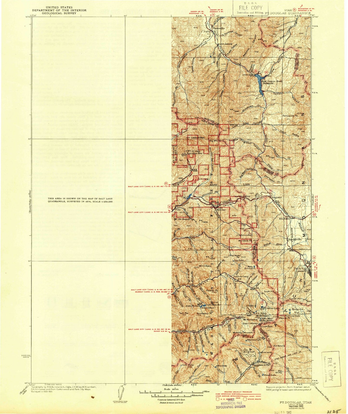
Historic 1928 Fort Douglas Utah 30'x30' Topo Map
Couldn't load pickup availability
Historical USGS topographic map of Fort Douglas in the state of Utah. Scale: 1:125000. Print size: 17" x 24"
This map was published in 1928 and is in the following counties: Davis, Morgan, Salt Lake, Summit, Utah, Wasatch.
The map contains contour lines, roads, rivers, towns, streams, and lakes. Printed on high-quality waterproof paper with UV fade-resistant inks.
Contains the following named places: Alta Guard Station, American Flag Shaft, Atwood, Baby McKee Mine, Mount Baldy, Barneys Creek, Barneys Wash, Basin Canyon, Bauchmanns Pony Express Station Historical Marker, Bennion, Big Bear Hollow, Big Dutch Hollow, Big Rock, Big Tree Creek, Bingham Creek, Bishops Canyon, Lake Blanche, Brighton Canal Extension, Broad Hollow, Butterfield Creek, Camp Clayton Historical Marker, Carbonate Mine, Cardiff Mine, Coalpit Gulch, Collins Gulch, Cottonwood Canyon, Crescent, Deaf Smith Canyon, Deer Fly Hollow, Deer Hollow, Derks Field, Dip Hollow, Dixie Hollow, Draper, Draper Irrigation Canal, Draper Irrigation Company Ditch, Draper Park, Dromedary Peak, Dry Creek, Dry Creek, Schuster Creek, Dry Gulch, Earl-Eagle Mine, East Canyon Reservoir, East Carbonate Tunnel, East Millcreek, Eclipse Mine, Emma Tunnel, Ferguson Canyon, Flagstaff Mine, Flagstaff Mountain, Flatiron Mesa, Lake Florence, Fredrick Tunnel, Gad Valley, Gad Valley Gulch, Galena Canal, Glacio Park, Globe Mines, Granger, Granite, Grants Grave, Lake Hardy, Harmony Park, Hells Canyon, Hillman Hollow, Hogback Summit, Hogum Fork, Howell Tunnel, Hunts Meadow Creek, Jodes Hollow, Jordan Park, Kearns, Kennebec Tunnel, Kimball Canyon, Kurzy Hollow, Latter Day Saints Church Records Storage Area, Ledgemere Picnic Ground, Left Fork Taylor Hollow, Lake Lillian, Little Giant Mine, Little Willow Creek, Lone Peak, Lone Tree Campsite, Lone Tree Canyon, Lower Bells Canyon Reservoir, Macfarlane Ranch, Major Evans Gulch, Mardiths Canyon, Maybird Gulch, Meadow Tunnel, Mellen Sand Spur, Merril Flat, Midas Creek, Middle Fork Dry Creek, Midvale, Mill Hollow, Mill Race Ditch, Mineral Basin, Mineral Flat, Mineral Flat Tunnels, Monte Cristo Mine, Montreal Hill, Mormon Flat Historical Marker, North Fork Deaf Smith Canyon, North Jordan Canal, Owens Meadow Hollow, Parker Hollow, Parleys Summit, Peruvian Gulch, Pollicks Canyon, Porcupine Creek, Porcupine Gulch, Porcupine Peak, Price Tunnel, Provo Reservoir Canal, Quincy Mines, Rabbit Hollow, Red Pine Fork, Red Pine Lake, Redrock Peak, Redwood, Reed and Benson Mine, Regulator Johnson Mine, Ridgeland Canal, Right Fork Taylor Hollow, Right Hand Fork Pollicks Canyon, Riverton, Riverton Siding, Road Canyon, Rocky Canyon, Rocky Hollow, Rocky Mouth Canyon, Rocky Ridge, Rose Creek, Saddle Rock, Sampson Mine, Sandy Ditch, Sandy Irrigation Canal, Sawtooth Creek, Schuster Creek, Second Hamongog, Sells Tunnel, Sheep Creek, Silver Bell Mine, Silver Glance Lake, Silver Lake, Silver Mountain Mine, Site of Dixie Hollow Pony Express Station, South Fork Dry Creek, South Fork Dry Creek, South Hecla Mine, South Jordan, South Jordan Canal, South Salt Lake, Stairs Gulch, Storm Mountain, Tanner Gulch, Tarbaby Mine, Taylor Hollow, Taylorsville, Temple Granite Quarry Historical Monument, Terminal Reservoir, The Salt Box, Thomas Canyon, Tucson Hollow, Twin Peaks, Twin Peaks, Union, Union and East Jordan Ditch, Utah and Salt Lake Canal, Utah Lake Distributing Canal, Vina Flat, Wasatch Drain Tunnel, Wasatch Mine, Wasatch Resort, West Jordan, West Jordan Park, Wet Fork Schuster Creek, White Pine Fork, White Pine Lake, Willow Creek, Willow Creek, Wood Hollow, Woodtick Hollow, Yankee Mines, Silver Lake Flat Reservoir, Silver Lake Flat Dam, Silver Lake Dam, White Pine Dam, Red Pine Dam, Lower Bells Canyon Dam 1, East Canyon Dam, Alta Ski Area, East Canyon Campground, Foothill, Hi-Way Park Campground, Jeremy Ranch, Lisa Falls, The Pfeifferhorn, O'Sullivan Peak, Snowbird Ski and Summer Resort, South Towne Mall, Sundial Peak, Thunder Mountain, Truckers Family Camp, Upper Bells Canyon Reservoir, White Baldy, White City, Willow View Estates, Vista Plat, Ashford Acres, Chattel Estates, Wallace Heights, Dusty Downs Estates, Webb and Palmers Addition, Willowbrook Estates, Sandy Acres, Decker Lake, Decker Creek, Alta, Altus, Endot, Gogorza, Lampton, Roper, Welby, Glendale Park, Peruvian Park, Tanners Flat Campground, Oak Ridge Picnic Ground, The Birches Picnic Ground, Silver Fork, Mount Aire, Albion Basin, Alexander Basin