MyTopo
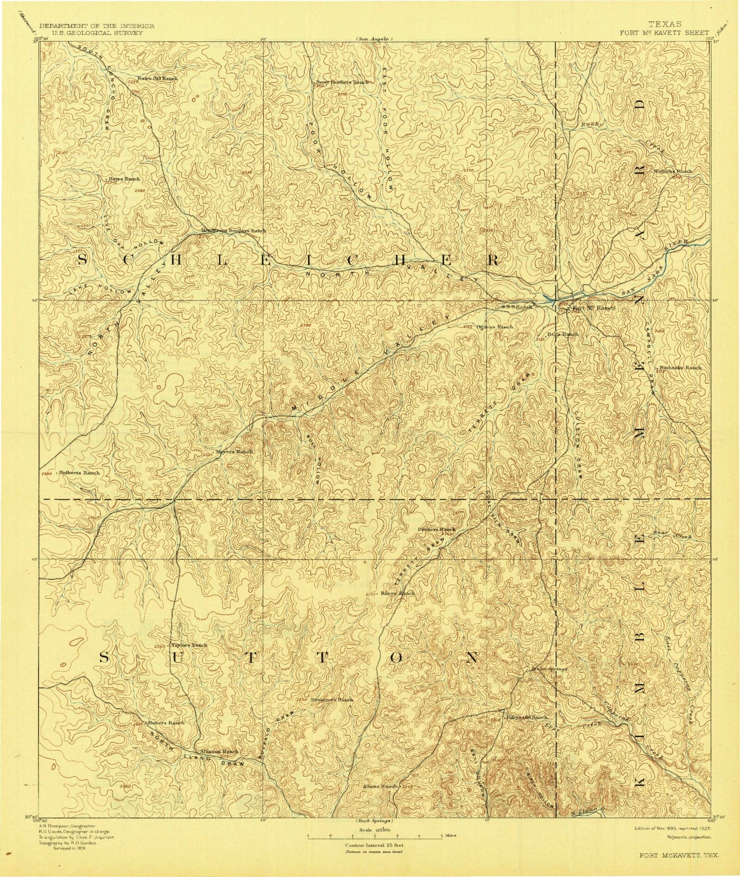
Historic 1893 Fort McKavett Texas 30'x30' Topo Map
Couldn't load pickup availability
Historical USGS topographic map of Fort McKavett in the state of Texas. Scale: 1:125000. Print size: 17" x 24"
This map was published in 1893 and is in the following counties: Kimble, Menard, Schleicher, Sutton.
The map contains contour lines, roads, rivers, towns, streams, and lakes. Printed on high-quality waterproof paper with UV fade-resistant inks.
Contains the following named places: A Murr Ranch, Alley Ranch, Allison Ranch, Baker Draw, Baptism Hole, Berrenda Draw, Black Waterhole, Bond Ranch, Brokeleg Mountain, Brown Hollow, Brown Ranch, Bruns Ranch, Buffalo Draw, Bull Hollow, Burrus Ranch, Butcher Pen Draw, C Valliant Ranch, Calistro Hole, Camilla Lake, Camp Sol Mayer, Campbell Draw, Cauthorn Ranch, Chadwick Ranch, Clarkson Ranch, Coal Kiln Draw, Colston Draw, Copeland Ranch, Coralina Ranch, Cowsert Ranch, Crescent Lake, Crosby Ranch, D Baker Ranch, Derrick Ranch, Dutton Ranch, Eaker Windmill, East Copperas Creek, East Poor Hollow, Eightmile Waterhole, Epps Creek, Ewing Ranch, F-6 Ranch, Figure Three Ranch, Fort McKavett, Fourmile Waterhole, G Allison Ranch, Gibbs Ranch, Graham Ranch, Halbert Ranch, Hardgrave Ranch, Henderson Ranch, Henderson Ranch, Holland Ranch, Holland Ranch, Hope Pond, Humble Camp, Hurricane Bluff Waterhole, J D Murr Ranch, J Hardgrave Ranch, J Reiley Ranch, Jacoby Ranch, Johnston Ranch, Jones Ranch, Joy Ranch, Joy Ranch, Kamar Oil Field, Kelley Ranch, Kelley Ranch, King Ranch, Kirkland Waterhole, Koy Ranch, L Edmiston Ranch, L Luckie Ranch, Lea Allison Ranch, Lee Hollow, Lehne Ranch, Limekiln Waterhole, Little Lake, Little Ogden Waterhole, Live Oak Hollow, Lopez Ranch, Lovelace Ranch, Luckie Ranch, Martin Ranch, McBurnett Ranch, McIntosh Ranch, McKegan Draw, Middle Copperas Creek, Middle Valley, Middle Valley Prong, Milligan Draw, Milligan Draw, Morales Ranch, Morales Ranch, Murr Ranch, N Gibbs Ranch, Ninemile Waterhole, North Valley, North Valley Prong, Otto Oil Field, Page Oil and Gas Field, Page Ranch, Panther Bluff Waterhole, Penn Tillery Gas Field, Poor Hollow, Pope Ranch, Powell Ranch, Quemado Ranch, R Hardgrave Ranch, Rattlesnake Draw, Rattlesnake Draw, Robertson Flat, Robinson Ranch, Rocking R Ranch, Round Hill, Russell Ranch, S Allison Ranch, S Baker Ranch, Schulz Ranch, Schwiening Ranch, Schwiening Ranch, Schwiening Ranch, Sevenmile Waterhole, Sheen Draw, Shroyer Ranch, Sixmile Waterhole, Spence Ranch, Stinking Windmill, Stites Ranch, Susch Ranch, Sykes Ranch, T Baker Ranch, Talbot Lake, Target Hill, Terrett Draw, Twelvemile Waterhole, Twentymile Waterhole, Twentymile Waterhole, U X Ranch, W D Valliant Ranch, W Edmiston Ranch, Walker Ranch, Wardlaw Ranch, Webster Ranch, White Ranch, White Ranch, Willow Waterhole, Wyatt Ranch, O'Harrow Oil Field, West Copperas Creek, Adams, Lake Hollow, Eldorado East Division, Fort McKavett State Historical Park