MyTopo
Historic 1900 Fort Mckinney Wyoming 30'x30' Topo Map
Couldn't load pickup availability
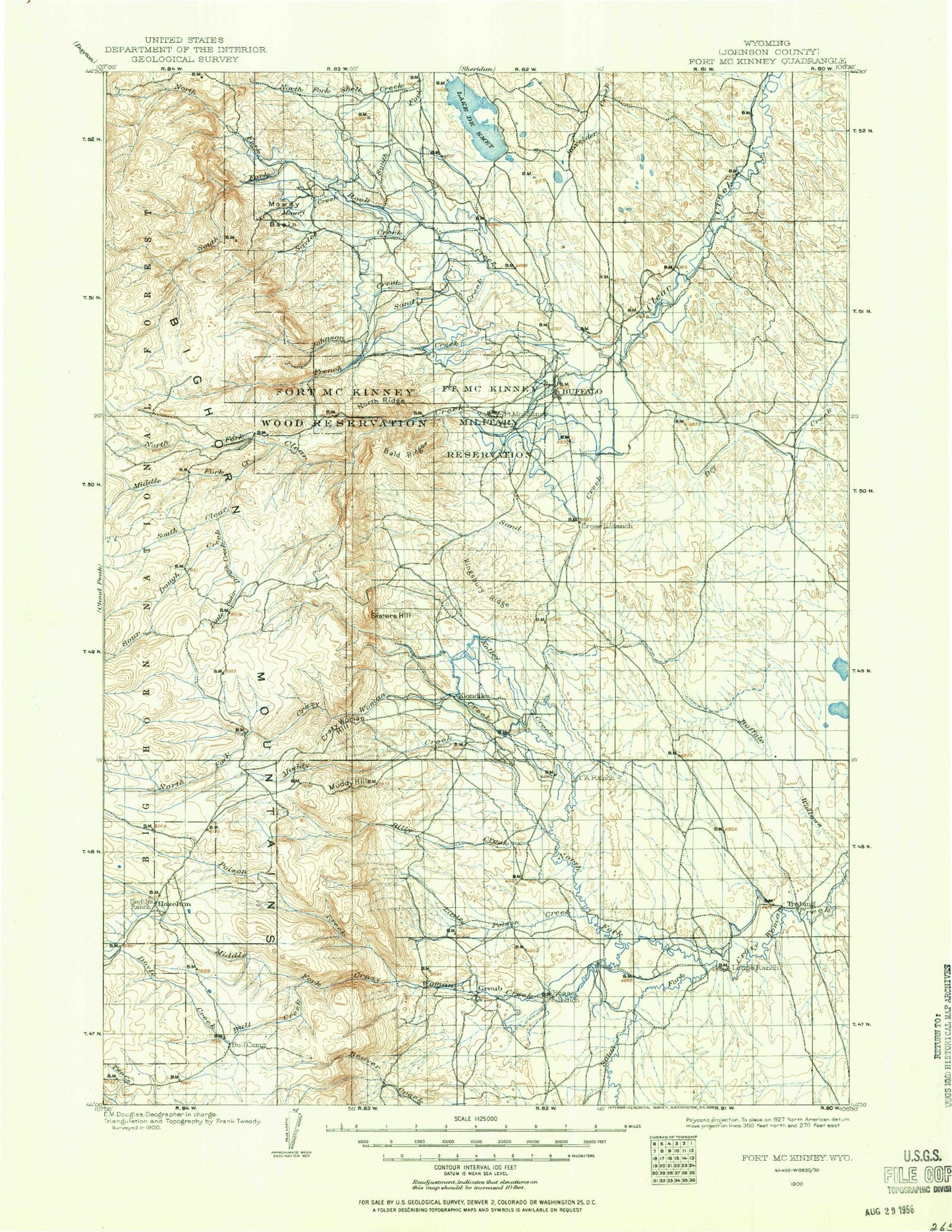
Historical USGS topographic map of Fort Mckinney in the state of Wyoming. Scale: 1:125000. Print size: 17" x 24"
This map was published in 1900 and is in the following counties: Johnson.
The map contains contour lines, roads, rivers, towns, streams, and lakes. Printed on high-quality waterproof paper with UV fade-resistant inks.
Contains the following named places: O'Malley Draw, Arno Draw, Barkey Ditch, Bates Draw, Big Draw, Bond Draw, Bozeman Trail Historical Marker, Buffalo, Bullwacker Creek, Canyon Campground, Center Draw, Center Draw, Colorado Flats Draw, Cook Draw, Coyote Draw, Crazy Woman Battlefield Historical Mark, Crazy Woman Campground, Crown Ditch, Cummings Creek, Cummings Ditch, Lake De Smet, Des Moines Ditch, Dowlin Reservoir, Dry Gulch, Dry Poison Creek, Dump Draw, E-la-ka-wee Camp, East End Draw, East Four Draw, East Healy Draw, East Prong Hakert Draw, Eder Draw, Evans Draw, Evans Draw, Father DeSmet Historical Monument, Fish Lateral, Fort Collins Canal, Four Draw, Four H Draw, Fox Ditch, Frog Pond, Gammon Draw, George Hess Draw, Gerkin Reservoir, Goodman Creek, Gossett Draw, H A Creek, Hakert Draw, Haley Draw, Hall Field Draw, Hallie Ditch, Hanson Sawmill, Healy Draw, Hodges Draw, House Draw, Johnson Creek Ditch, Kempton Ditch, Kumor Draw, Lake DeSmet Canal, Last Chance Draw, Lawrence Draw, Lewis Draw, Lily Ditch, Little North Fork, McNeese Draw, McNeese Draw, McVenry Draw, McGrath Ditch, Mitchell and Long Ditch, Moore Reservoir, Muddy Creek Cow Camp, Murray Draw, Negro Creek, Neilson Draw, Ninemile Waterhole Draw, North Healy Draw, North Prong Bilderback Creek, Northside Ditch, Pierson Ditch, Poison Creek, Pole Creek, Pride of the Valley Ditch, Prosinski Park, Purdy Reservoir, Red Gulch, Red Hills, Redman Ditch, Regina Draw, Ritchey Ditch, Robinson Canyon, Ruby Ditch, Sand Creek, Sand Draw, Sayles Creek, School Section Draw, School Section Draw, Seney Point, Seventysix Creek, Shell Creek Reservoir, Sixmile Ditch, Smith Ditch, Smith Draw, South Fork Bull Creek, South Fork Crazy Woman Creek, South Fork Shell Creek, South Prong Wallows Creek, South Side Draw, Sparks Reservoir, Spring Creek, Spring Draw, Spring Draw, T A Ranch, The Wallows, Tisdale Divide, Trabing, Trabing Draw, Trabing Dry Creek, Twenty and One Half Ditch, Waegle Draw, Wallows Creek, Watt Draw, West Fork Murray Draw, West Fork Trabing Dry Creek, Willow Marsh, Wright Draw, Yarwood Ditch, T A Hills, Louise Creek, Webber Creek, Gossett Creek, Muddy Creek Guard Station, Bald Hill, Bald Ridge, Balm of Gilead Creek, Basco Creek, Billy Creek, Brown and Foster Ditch, Brush Creek, Buffalo Park, Bull Camp Park, Bull Creek, Burnett Creek, Caribou Creek, Circle Park, Circle Park Creek, Corpe Creek, County Youth Camp, Crazy Woman Mountain, Cross Ditch, Cross H Cow Camp, Cull Watt Park, Ditch Creek, Doyle Creek, Dry Muddy Canyon, Dry Muddy Creek, Dry Poison Creek, Duck Creek, Eagle Ditch, Elgin Creek, Elgin Park, Foot Creek, French Creek, French Creek Cow Camp, Gammon Creek, Grommund Creek, Gossett Canyon, Grouse Mountain, H F Bar Ranch, Hay Gulch, Hazelton, Hazelton Ditch, Hesse Creek, Hettinger Picnic Area, Hunter Creek, Hunter Mesa, Hunter Ranger Station, Jim Crow Ditch, Johnson County Ditch, Johnson Creek, Kelly Creek, Keno Creek, Kingsbury Ridge, Klondike Ranch, Little North Fork Crazy Woman Creek, Little Sourdough Creek, Lower Doyle Creek Campground, Lucasta Camp, Lynx Park, Mattox Creek, McDonald Creek, Merle Creek, Middle Clear Creek, Middle Fork Campground, Middle Fork Crazy Woman Creek, Middle Rock Creek, Moeller Ditch, Mosier Gulch, Mowry Basin, Mowry Basin Ditch, Mowry Creek, Muddy Creek, North Clear Creek, North Fork Crazy Woman Creek, North Fork Picnic Area, North Fork Sayles Creek, North Fork Shell Creek, North Ridge, North Rock Creek, Oliver Creek, Paradise Ranch, Penrose Ditch, Pheasant Creek, Poison Creek, Pole Creek, Rabbit Creek, Red Canyon, Red Creek, Rock Creek, Sand Creek, Schoolhouse Park, Seven Brothers Creek, Sisters Hill, Sourdough Campground, Sourdough Creek, South Clear Creek, South Fork Campground, South Rock Creek, Spring Creek, Spring Creek, Spring Draw, Stone Mountain, Taylor Creek, Tepee Creek, The Pines, The Speedway, Tie Hack Campground